Chasing Hydrocarbon Plays Along the Rona Ridge
Review of new 3D seismic data in the Faroe-Shetland Basin has revealed new hydrocarbon potential of the Early Cretaceous syn-rift and Precambrian fractured basement plays along the northern extent of the Rona Ridge – one of the least mature producing regions on the UK Continental Shelf (UKCS).
The Faroe-Shetland Basin (FSB) west of the Shetland Islands is one of the least mature producing regions on the UK Continental Shelf (UKCS). Although the Central North Sea is considered by the Oil and Gas Authority, the UK Government industry regulator, to contain the largest yet-to-find potential on the UKCS, the West of Shetland area offers arguably the largest remaining opportunities for significant new finds (Austin, Cannon and Ellis, 2014).
Figure 1: Map of the Faroe-Shetland Basin and the location of CGG’s North Rona Ridge 3D PSDM seismic survey. © CGG.
Exploration activity in the basin began in 1972, with more than 30 wells drilled in the following decade. Initially, exploration focused on simple tilted fault block traps, analogous to the North Sea, in relatively shallow waters (<500m) along the south-east flank of the FSB. The first hydrocarbon discovery, although sub-economic, was made by Shell in 1980 at the 206/2-1 well, located close to the present day Greater Laggan Area. During this initial exploration phase the giant Clair (4 Bboe STOIIP) and Victory fields were discovered in Devono-Carboniferous and Lower Cretaceous sandstones respectively. Due to technological and commercial constraints, these fields lay undeveloped for many years. During the 1980s advances in deepwater drilling technologies shifted exploration activity into the deeper parts of the basin, such as the Flett Sub-basin, where sub-economic gas was found within the Paleocene. Further sub-economic discoveries were made until the discovery of the Foinaven and Schiehallion fields in the early 1990s. These discoveries were driven by advances in seismic technology, particularly amplitude-versus-offset (AVO) analysis, and led to the establishment of the Paleocene oil play with total reserves in excess of 1 Bboe.
Until recently, much of the focus has been on these post-rift plays. However, recent successes, including the development of the Clair field, the Glendronach gas discovery in Lower Cretaceous turbiditic sands and the Lancaster field, the UK’s first fractured basement oil play, have renewed focus on these deeper and more challenging syn-rift and pre-rift plays (Figure 1).
Hydrocarbon Plays at Multiple Stratigraphic Levels in the Faroe-Shetland Basin
Over the more than 40 years of exploration in the FSB, plays have been identified at all tectono-stratigraphic levels (Figure 2), with hydrocarbons produced from reservoir intervals contained within structural and combination structural/stratigraphic traps. Within the pre-rift, the deposition of thick sequences of non-marine clastics deposited in fluvial, aeolian and lacustrine environments constitutes the main reservoir intervals of the Devono-Carboniferous play, typified by the Clair field. More recently, the development of Precambrian, Lewisian metamorphic basement along the Rona Ridge has established a fractured basement play.
Figure 2: Chronostratigraphy of the study area showing key reservoir intervals. © CGG.
A number of rift phases associated with the opening of the North Atlantic in the Triassic and Early Cretaceous led to the deposition of the main syn-rift plays in the basin. In the Triassic, continental sediments deposited in a series of extensional half-grabens constitute the reservoir intervals at the Strathmore discovery. In the Early Cretaceous, major extension led to the deposition of sandstone-dominated successions in marine conditions. The Lower Cretaceous succession in the West Shetland Basin includes fan delta and shallow marine sandstones deposited in narrow half-grabens east of the Rona Ridge (e.g. Victory Sandstone, Victory field). This succession also contains mass-flow sandstones and mudstones deposited on the basin-ward side of the platform-bounding fault system as seen in the Royal Sovereign Sandstone of the Glendronach field (Larsen, Rasmussen and Hjelm, 2010).
Within the post-rift sequence, by far the most dominant play is the Paleocene deep marine sandstones. It consists of amalgamated channel complexes derived from a sand-dominated shelf to the south-east and deposited in the Foinaven and Flett Sub-basins. The play is typified at the Foinaven and Schiehallion fields (Lamers and Carmichael, 1999). The majority of these plays are charged by Upper Jurassic-sourced hydrocarbons generated by the Kimmeridge Clay Formation, which was deposited in an open marine setting under anoxic ocean bottom conditions over most of the area during a widespread marine transgression. It tends to generate a low wax oil. There is also upside potential from Middle Jurassic shales deposited in more restricted marine/lagoonal settings that tend to produce a waxier oil grade. Both source intervals are penetrated by well 206/5-1 (Figure 1).
Post-rift deposition of thick, deep marine mudstones provides excellent seals for the deeper pre- and syn-rift plays, whilst tuffaceous units associated with Neogene volcanism (i.e. from the Icelandic Plume) provide regional seals for the shallower plays.
Overcoming Geological Challenges in the Faroe-Shetland Basin
Figure 3: Rich-azimuth acquisition configuration. © CGG.
To date, much of the exploration focus has been on the shallower, post-rift plays because of the known geological, geophysical and operational challenges for seismic imaging that have historically hampered the targeting of the deeper syn- and pre-rift plays in the FSB. These challenges are mostly associated with the presence of intrusive and extrusive volcanic rocks, emplaced around 55 Ma due to the impinging Icelandic Plume, the proximity of the basin to the Shetland Islands and strong along-strike currents. This has resulted in a lack of seismic signal penetration and poor illumination, particularly of dominant north-east–southwest basin-bounding faults.
In 2018/19 CGG undertook a multiclient 3D PSDM seismic survey covering 3,600 km2 of the North Rona Ridge and adjacent Foula and West Shetland Basins. The data were acquired with a rich-azimuth acquisition configuration consisting of dual triple-source vessels with significant lateral offset, which, when combined with advanced imaging technology, offered enhanced illumination underneath the volcanic intrusions present in the area and increased dip-line sampling to improve fault imaging (Figure 3). The seismic interpretation of this data has allowed for a new assessment of the exploration potential of deeper syn- and pre-rift plays along the Rona Ridge.
Chasing the Post- and Syn-Rift Plays on the Rona Ridge
A full 3D seismic interpretation has revealed the geometry of several key stratigraphic horizons in the area, including the Top Lewisian Basement, Top Lower Cretaceous, Top Shetland Group and Top Balder Formation, with age calibration from several key wells. The structural interpretation has been complemented with attribute analysis to aid understanding of reservoir distribution in the study area.
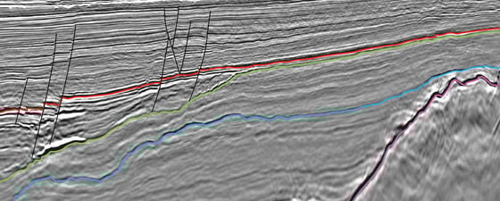
For the prospective syn-rift interval, structural interpretation of the Top Lower Cretaceous marks the top of the prospective stratigraphic units identified at the Victory and Glendronach discoveries. The interpretation of this interval has been extended away from these areas to identify a more expansive network of Early Cretaceous syn-rift wedges towards the north-east. These are deposited on fault terraces on the eastern side of the Rona Ridge and onlap the Lewisian Basement. It has been interpreted that, unlike the deeper marine, turbidite-prone sand sedimentation to the west of the Rona Ridge, this more proximal setting provided conditions for the deposition of stacked fan delta-to-shoreface sandstones and inner shelf mudstones in a ponded, hanging wall, back-basin (Larsen, Rasmussen and Hjelm, 2010). This more proximal setting would be conducive to improved reservoir characteristics, such as higher porosity and permeability, thickness and net-to-gross. This is demonstrated by the Victory wells (207/1-1, 2, 3 and 1a-5) where over 200m of Lower Cretaceous sand is penetrated with good reservoir properties. These syn-rift wedges form stratigraphic traps with top seal provided by the thick post-rift shales of the Shetland Group (Figure 4).
Figure 4: Potential Early Cretaceous syn-rift targets. © CGG.
Elsewhere within the study area, the post-rift also shows potential with the presence of Paleocene turbidite sands. The structural interpretation of the Top Balder Formation and Top Shetland Group has been used to constrain RMS amplitude extractions of the Paleocene section with the results revealing information on the distribution of Paleocene reservoirs in the deeper Foula Sub-basin. As with many other Paleocene discoveries to the south, the Paleocene Vaila sands encountered at the Glenlivet field display characteristic amplitude brightening. The amplitude is indicative of fluid response and excellent reservoir properties, with 61m net sand thickness, net-to-gross of 94% and good porosity (Figure 5).
Figure 5: Interpreted dip-line and RMS amplitude extraction (inset) showing the amplitude response of Paleocene reservoir targets in the FSB. © CGG.
Fractured Basement Potential in the Northern Rona Ridge
The northern Rona Ridge may also provide upside potential within the fractured Lewisian Basement to the northeast of the currently producing Lancaster field in the FSB (Figure 1). From the structural interpretation of the top basement horizon a number of structural closures can be identified. The seismic data reveal the presence of numerous faults, which are likely to be associated with fracturing, within the basement itself. These fault and fracture zones provide the required porosity and permeability for good hydrocarbon production. The location of these closures, adjacent to the main basin-bounding fault, provide a direct pathway from the source kitchen in the deeper basin (Figure 6). A number of wells penetrating the basement in the study area encounter an upper ‘weathered zone’ consisting of a brecciated section with metasediment clasts. As elsewhere in the basin, the 208/27-1 well data, in particular, confirm the upside potential of a fractured basement play, with hydrocarbon shows within the basement itself.
Figure 6: Interpreted dip-line showing potential Basement prospect forming large structural closure (inset). © CGG.
Further ‘Victory’ Remains
Review of the new 3D seismic data in the FSB has revealed the new potential of the Early Cretaceous syn-rift and Precambrian fractured basement plays along the northern extent of the Rona Ridge. The configurations of these play fairways mirror those that have brought success to the south-west of the study area.
One question that remains, however, and is the focus of further work, concerns the migration of hydrocarbons from the deeper basin into the interior back-basin regions on the eastern flank of the Rona Ridge. Fault analysis and careful mapping of migration pathways are key elements to de-risk these plays further.
References:
Austin, J.A, Cannon, S.J.C., and Ellis, D. (2014). Hydrocarbon Exploration and Exploitation West of Shetlands. From: Cannon, S.J.C., and Ellis, D. (2014). Hydrocarbon Exploration to Exploitation West of Shetlands. Geological Society, London, Special Publications, 397, 1-10.
Lamers, E., and Carmichael, S. M. (1999). The Paleocene Deepwater Sandstone Play West of Shetland. Petroleum Geology of Northwest Europe: Proceedings of the 5th Conference (pp. 645-659). London: Geological Society.
Larsen, M., Rasmussen, T., and Hjelm, L. (2010). Cretaceous Revisited: Exploring the Syn-Rift Play of the Faroe-Shetland Basin. Proceedings of the 7th Petroleum Geology Conference (pp. 953-962). London: Geological Society.


