Renewing Oil and Gas Exploration in Denmark
Denmark has a rich exploration history with numerous hydrocarbon discoveries totalling over 100 MMboe in recoverable reserves. Recently reprocessed vintage 3D data provides the perfect platform to support any renewed exploration efforts in Denmark.
After 53 years of hydrocarbon exploration in Denmark – the first North Sea well was drilled by the DUC (Dansk Undergrunds Consortium) in 1966 – the varied geology, stabilisation of operators and an oil price that at over $50 per barrel is now favourable to North Sea exploration have combined to encourage new exploration activity, as new wells have been or will be drilled offshore Denmark in the coming months.
Figure 1: South Arne, located in the Danish North Sea has produced oil and gas since 1999. Insert: Map of the ION multi-client Denmark 3D survey covering the Danish offshore area from the Mid North Sea High to the Tail End Graben. Image source: Hess Corporation. Map: ION Geophysical.
These include the recently completed Jill-1 well (Figure 6) drilled by Hess on Licence 06/16, which was targeting the chalk interval at approximately 3,400m depth. This was the first well in the Danish North Sea since 2015, and it will be followed by the High Pressure-High Temperature Vibe-1 well in the Central Graben targeting an Upper Jurassic fan complex, which is planned by Wintershall-DEA for 2020. Wood Mackenzie has recently described North Sea exploration as, “making a comeback in 2019”, adding, “bigger budgets and company portfolios are brimming with prospects matured through the downturn” (Wood Mackenzie, 2019).
Geological Challenges of Oil and Gas Exploration in Denmark
Figure 2: Chronostratigraphic chart modified from Hemmet (2005), showing the main petroleum elements of the Danish Central Graben with stratigraphic intervals of known fields, discoveries and leads highlighted.
Denmark has a rich exploration history with numerous hydrocarbon discoveries totalling over 100 MMboe recoverable reserves from nearly 20 fields, including Harald, Hejre, South Arne, Valdemar, Roar, Tyra, Gorm, Skjold, Halfdan and Dan (IHS Edin, 2019). Production first started in 1972 and the country has been a net exporter of oil and gas since 1997. The larger of these discoveries were found across multiple stratigraphic levels, ranging from Early to Late Jurassic, and Lower and Upper Cretaceous, predominantly within the chalk, while a significant number of smaller discoveries have been made within the Permian, Triassic and Palaeogene clastics, as demonstrated in Figure 2. The hydrocarbons in the first producing field, Dan, are reservoired in Upper Cretaceous chalk, which is characterised by high porosities and very low permeabilities, demonstrating the challenging geological environments typical of much of the North Sea.
Therefore, this varied and interesting geological setting, with plays in multiple stratigraphic intervals, makes Denmark the perfect location to demonstrate the value of a regional depth reprocessing project recently undertaken by seismic company ION, which has a long and successful history of 3D proprietary processing, with a significant amount of experience – over 140 surveys – in the North Sea. The company is leveraging this vast North Sea experience to produce the highest quality depth product out of the contiguous surveys that make up the Denmark 3D project.
Rejuvenation Legacy Seismic Datasets Offshore Denmark
Denmark 3D is a multi-client survey that covers about 10,650 km2 of the Danish offshore area, from the Mid North Sea High to the Tail End Graben, in quadrants 5605, 5604, 5603, 5503, 5504 and 5505 of the Danish North Sea.
Figure 3: Amplitude spectra showing the broader frequency range after the application of WiBand compared to the vintage. © ION Geophysical.
The 3D dataset is comprised of multiple contiguous vintage surveys that are currently being reprocessed to create a continuous regional volume from field tapes to PSDM. Phase 1 (see Figure 1) will be completed in January 2020 and the data shown in this article is an enhanced fast track version, with velocity model building (VMB) complete down to base chalk. The aim of this phase was to combine three different surveys, in order to demonstrate what can be achieved by applying a modern depth processing workflow to existing legacy surveys.
Prior to imaging work, a fully tested pre-processing sequence was applied, incorporating denoise, debubble, deghosting, zero-phasing, shallow water demultiple and regularisation. Special attention was paid to the application of WiBand (ION’s deghosting technique), resulting in a broader frequency range compared to the vintage (Figure 3), and allowing better matching between the three input surveys due to the removal of the source and receiver ghosts (Figure 4).
Figure 4: a) Cross-line through a post stack merge of the Angelina (2007) and South Arne (1995) surveys. © ION Geophysical.
Figure 4: PSDM input to VMB down to Base Chalk; the survey boundary has been removed and the intra-chalk formations are more clearly defined. © ION Geophysical.
PreSDM model-building was required to adequately resolve the structurally and lithologically complex subsurface of the project area. This was done in an iterative, top-to-bottom approach, with each iteration addressing specific intervals of a complex anisotropic model. The PreSDM model was built using automatic picking and gridded tomography as well as using full wavefield inversion (FWI) and key horizons at strong impedance boundaries or velocity contrasts in order to better constrain the velocity regimes.
Water depths in the region are around 50m and shallow channels are prevalent, meaning extra care was required during VMB in the shallow section in order to resolve the numerous velocity anomalies. This resulted in a marked improvement in some of the stack distortions seen in previous work.
Two tomographic iterations were carried out for the chalk velocity estimation, with FWI also being incorporated for the chalk and pre-chalk velocity derivation.
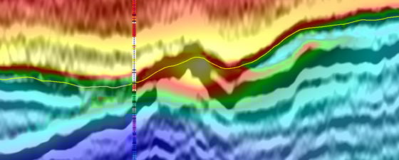
The success of the velocity model build is highlighted by a good match at the wells from the area, including Bertel-1 (see Figure 5). Good matches were also identified with Isak-1, Katherine-1, Nora-1, Ophelia-1, Sten-1 and Svane-1A.
Figure 5: a) Bertel -1 well showing sonic and ION velocity. b) Velocity seismic overlay at well location, showing the good match with the Bertel-1 well. © ION Geophysical.
Supporting Renewed Oil and Gas Exploration in Denmark
A change in the dynamic of hydrocarbon exploration and development in the Danish offshore, precipitated by the 2015 decline in the oil price, has seen takeovers and mergers amongst operators (Nordsøfonden, 2019). Most noticeable of these were the acquisition of Maersk Oil by Total in 2017, the INEOS purchase of DONG Energy’s entire oil and gas business in 2017 and the recent Wintershall-DEA merger in 2019. This has resulted in a hiatus in exploration drilling so that, until Jill-1, Maersk’s 2015 drilling of Xana-1X was the most recent (IHS EDIN, 2019). This well successfully demonstrated the presence of hydrocarbons in Upper Jurassic sandstone in Licence 9/95 in the Central Graben, but since then operators have taken time out to take stock of their assets and plan strategies for future hydrocarbon exploration.
Figure 6: A) In-line through the Jill intra-chalk target showing the high resolution imaging of the intra chalk formations, with approximate location of Jill-1 displayed. © ION Geophysical.
All eyes are on Denmark, and not just because of the recent industry comeback, but due to hesitation on the most recent licence round. On 5 February 2019 the Danish Energy Agency announced it had received five applications from four companies in the 8th Licensing Round: Ardent Oil, Lundin Petroleum, MOL and Total. The award of these licences was expected in August 2019, but at the time of writing no awards have yet been made.
The impact of this is not yet clear, but ION’s newly reprocessed PSDM 3D seismic provides the perfect platform to support any renewed exploration efforts in Denmark. This product will be available at an affordable rate and specifically targeted for the licensed and unlicensed acreage west of 6° 15’ E, which can only help stimulate the growth in the Danish offshore.
Further Reading on Oil and Gas Exploration in Denmark
Discover New Value in Legacy Data with Denmark 3D
ION Geophysical
ION’s newly reprocessed PSDM 3D seismic data provides the perfect platform to support any renewed oil and gas exploration efforts in Denmark.
This article appeared in December, 2019
Regional 3D Seismic Offshore Denmark
ION Geophysical
The ION Denmark 3D is a regional multi-client seismic survey, covering approximately 10,650 square kilometres of the Danish offshore area from the Mid North Sea High to the Tail End Graben.
This article appeared in October, 2019


