A Closer Look at the Hydrocarbon Plays of the South Atlantic
The timing of continental extension relative to salt deposition and the impact of pre-salt faulting is critical to reservoir formation and exploration success in the South Atlantic. Major advances in broadband seismic data processing offer clearer imaging, allowing a closer look at the elements of the prolific plays and their tectono-stratigraphic boundary conditions.
The transition from continental extension to seafloor spreading marks the separation of continents and the development of conjugate passive margin systems. It causes major restorations of the regional tectonic conditions, has wide implications for basin evolution, and affects the formation of petroleum systems. In restricted environments, the continental break-up commonly occurs somewhere close to the period of salt deposition, such as in the South Atlantic basin or the Gulf of Mexico. Unsurprisingly, it is widely debated whether salt deposits postdate or predate the continental break-up. Depending on the timing, salt basins might have formed either separately on each conjugate margin including scenarios with salt deposited on newly formed oceanic crust, or as a large salt basin that has been subsequently split during break-up.
Figure 1: Isopach map of layered evaporite sequence across the Santos Basin illustrating the salt thickness variation according to the tectono-stratigraphic domains. © PGS.
Analysis on extensional faults near the base of salt allows us to narrow down the critical time interval of continental separation and provides insights into the condition during reservoir formation of the pre-salt plays. Key prerequisites for such investigations are high resolution regional-scale seismic products offering reliable and accurate imaging of the base of the salt and the reservoir-bearing sequences below, including their fault-controlled morphology. PGS implement a focused and integrated velocity model-building process, including refraction and reflection Full Waveform Inversion over the entire depth section, rigorously constrained by geological compatibility. High resolution broadband seismic imaging and Least-Squares Migration (LSM) provide high fidelity images of the pre-salt sediment geometries and fault architecture.
Comparing Santos Basin, Brazil…
The pre-salt São Paulo Plateau is a riftrelated basement high which contains the regional fairway for the prolific hydrocarbon play associated with pre-salt carbonate build-ups. Based on the salt and post-salt architecture (Figure 1), the plateau region is divided into three tectono-stratigraphic domains. The north-western Albian Gap domain is an approximately 40 km-wide zone of roll-over structures that displaced most of the Aptian layered evaporite sequence (LES) and largely lacks the post-salt Albian carbonates. A system of extensional faults (Cabo Frio Fault) delineates the Albian Gap from the adjacent mini basin domain of thick layered evaporite sequences bounding mini basins filled with postsalt sediments. Highly reflective layers of anhydrite and other evaporites within the LES indicate complex internal folding, while rather transparent sections refer to accumulations of intra-formational mobilized halite. The dominance of mini basins diminishes towards the adjacent fold belt domain, which reveals increasingly well imaged folding and diminishing complexity towards the distal section of the São Paulo Plateau.
Figure 2: Schematic section through the entire São Paulo Plateau outlining major pre-salt faults and the thickness variation of the LES. © PGS.
The São Paulo Plateau is bound by normal faults, such as the Merluza Graben system, with fault throws in excess of 3,500m. On the plateau, similar northnorth-east to south-southwest trending faults form the basis of major pre-salt hydrocarbon reservoirs. Displacement along these fault systems continued during the deposition of the LES, which accumulated up to 4,000m in thickness at the graben systems, while the São Paulo Plateau received about 1,150–1,500m of evaporite deposits (Figure 2).
A key objective of the PGS regional-scale imaging project Santos Vision, which encompasses more than 49,000 km2 of broadband 3D seismic, is the reliable and accurate imaging of the base of salt and the reservoir-bearing sequences below, including their fault-controlled morphology. The latter is a major element in play fairway analysis, and a useful guide to define hydrocarbon leads and prospects within the pre-salt play. Constructing an accurate model of the heterogeneous seismic velocity signature within the LES and its cover sequences is essential not only for imaging the pre-salt structural and depositional geometries, but also for assessment of the seal risk for the pre-salt reservoirs.
…to Kwanza Basin, Angola
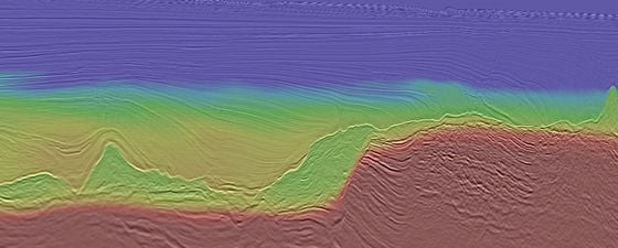
Figure 3: West–east seismic section at the Kwanza Basin passive margin illustrating the withdrawn and partially welded salt layer. The pre-salt fault pattern highlights tilted fault blocks with onlapping sag-phase sediments. A subset of the faults affect the salt base that covers locally eroded pre-salt sections at uplifted fault blocks. Image aspect ratio is 1:2. © PGS.
The West African margin is conjugate to the Brazilian margin and reveals similar architectural elements for the rifted pre-salt section. However, separation of the continents was rather asymmetric and left a significantly wider portion at the Santos Basin than at the West Africa counterpart, including the Kwanza Basin of Angola. These differences are reflected in the visible post-salt architecture. The Kwanza Basin is dominated by a basinward gravitational gradient that causes up dip extension (Figure 3), which is balanced by downdip compression via the salt layer serving as the kinematic detachment. The Santos Basin lacks such a gradient at the São Paulo Plateau, where lateral salt movement due to displacement loading is caused by propagating Upper Cretaceous sedimentary wedges (Figure 4).
Tectonic Activity & Timing at the Base Aptian Salt in the South Atlantic Basins
Timing and tectonic context of fault activity at the base of the Aptian salt in the South Atlantic basins affects the development of the pre-salt petroleum system. It has a direct impact on trap formation and hydrocarbon charge, while the prolific carbonate reservoir facies are associated with the fault-controlled paleo-relief, besides using sub-salt faults as proxy for the continental break-up. Rift-related faulting further affects the reservoir fluid due to localized hydrothermal circulation (CO2; thermogenic gas). In essence, imaging individual fault magnitude and depth scale is critical to mitigate a wide range of hydrocarbon risk elements.
Figure 4: Santos Basin’s Merluza half-graben revealing propagation of a post-salt Upper Cretaceous sediment wedge from the graben onto the São Paulo Plateau (Albian Gap). The São Paulo Plateau section displays the effect of footwall uplift and erosion into the rift phase sediments (righthand side). © PGS.
With regard to the Santos Basin, the base of salt has a rugose relief that ranges in depth from 6,000 to 7,000m at the São Paulo Plateau. It is bound to the west by a prominent half-graben system that throws the base of salt down to a depth of more than 10,000m along northnorth-east to south-south-west trending normal faults (Merluza Graben, Figure 4). The faults align with the dominant fault system at the São Paulo Plateau where individual fault throw rarely exceeds 500m and this forms the grain of the pre-salt play fairway. Displacement along these faults was ongoing during development of the pre-salt reservoir carbonates and influenced the shallow marine to lagoonal paleo-environment on the São Paulo Plateau. Fault movement continued at least into the early stages of the Aptian evaporite deposition as clearly indicated by the displacements of the salt base (Figures 4 and 5). Wellimaged volcanic layers interbedded with the pre-salt reservoir section are a useful reference for fault activity and represent initially horizontal layers suitable to restore the paleo geometries. Younger growth strata within adjacent halfgrabens indicate post-volcanic fault movement, and talus signatures along fault scars are evidence of exposure during pre-salt carbonate build-ups. Up-thrown fault blocks at the São Paulo Plateau reveal additional evidence of erosion at the top of the pre-salt sequences and a paleo-relief subsequently covered by evaporite deposits (Figure 4). In addition, the high-resolution broadband images reveal a seismic signature that indicates lateral facies changes at the reservoir level when flattened on the volcanic layers.
Figure 5: Original (top) and flattened (bottom) pre-salt section highlighting the paleo-relief and localized erosion at an uplifted fault block. This indicates active tectonics during the initial salt deposition phase. © PGS.
Large-scale fault displacement along the São Paulo Plateau edges (Merluza Graben) is associated with significant footwall uplift and local erosion down to the rift section (Figure 4). Onlapping sag-phase sediments on the flanks of fault blocks indicate that the formation of the Merluza Graben and São Paulo Plateau was active during the late pre-salt stage and evolving grabens accumulated significantly more evaporite section than the plateau, which resulted in an observable larger salt budget over pre-salt graben structures. The diachronous evaporite deposition were initiated at the deep grabens and later reached the São Paulo Plateau.
The Kwanza Basin reveals a similar faulting history for the pre-salt section, though the overall passive margin setting differs from that of the Santos Basin/São Paulo Plateau. Pre-salt faulting actually affects the salt sequence by offsetting its base. In rare examples (Figure 3) the faulting appears to truncate a thin salt layer, giving the impression that the top of salt was also affected by pre-salt faulting. However, this is a heavily depleted salt section and the imprint on its top might be the result of salt withdrawal.
Faulting was active during the pre-salt deposition and certainly affected the depositional (erosional) environment for the hydrocarbon reservoirs. Fault activity continued at least during the early stages of salt deposition and initiated in the graben structures and local depressions, while pale-ohighs were eroded and subsequently covered by the evaporite sequence. Faulting ceased sometime during the deposition of the Aptian salt restoration of the rifted margins falls into this period.
Hiqh Quality Seismic Imaging is Critical for South Atlantic Oil and Exploration
The success of hydrocarbon exploration and production demands high quality seismic images that provide critical subsurface insight into prospective petroleum systems, enable an improved classification of play types, and mitigate the overall prospect risk. Both Santos Vision and high quality 3D GeoStreamer data from Kwanza provide a high level of detail in post and pre-salt imaging. These datasets are ideally suitable for exploration efforts, including prospect maturation and hydrocarbon risk assessment of the pre-salt reservoirs. Innovative technologies such as LSM offer a further leap in enhanced image quality that help to delineate pre-salt fault patterns at very high detail and support confident seismic stratigraphy analysis.


