Insights into Exploration – Tools for a New Era
Streamlining the process of exploration to provide a better understanding of geological risk for frontier plays.
Despite a protracted low oil price, the number and geographical distribution of wildcat exploration wells scheduled throughout the coming year demonstrate that frontier exploration for new plays remains an important part of the hydrocarbon industry. While this trend partly reflects previous work commitments, it is also defined by the long-term necessity for operators to replace reserves and for governments to ensure energy security.
Delving into the Frontier
However, frontier exploration is not without considerable geological risk, as demonstrated by increasing finding costs across the industry. How can we streamline the process of exploration and provide a better understanding of geological risk, even for frontier plays where hard data are often scarce? Halliburton Landmark’s approach uses an innovative suite of exploration tools that provide a mechanism for validating play concepts. These tools are built around the integration of multidiscipline datasets, resulting in a series of geological models ranging from plate tectonics, palaeogeography and palaeoclimate, to sequence stratigraphy and burial; combined, these models help ensure more informed predictions of the subsurface.
Frontier exploration not only describes the search for hydrocarbons in undrilled geographic areas (Figure 1a), but also underexplored stratigraphy in mature basins and the development of tight or unconventional plays (Figure 1b). Many basins therefore have frontier play potential that could yield considerable undiscovered hydrocarbon reserves. However, frontier exploration poses a higher risk of failure because of the paucity of data control compared to more mature or more accessible assets. Exploration geologists therefore need to mitigate such risks and create a well-reasoned conceptualisation of the subsurface, integrating interpretations from plate to pore scale. Here we show how exploration geologists can make informed predictions on a range of features within a basin, including its origin, likely stratigraphy, the quality and effectiveness of play elements, and, ultimately, likely hydrocarbon endowment.
Figure 1. (a) Frontier exploration can occur in either unexplored areas or deeper stratigraphic intervals, leading to a broadening and deepening of exploration (b). New discoveries contribute to the rejuvenation of reserves, outlined in the pseudo creaming curve.
Plate Reconstructions and Stratigraphic Heterogeneity
Plate tectonic models are powerful tools for characterising the geological history of a region (Figure 2) and are built using a range of datasets, including seismic, potential field, geochronology, biostratigraphy, and palaeoclimate information. By carefully integrating these data, plate tectonic models provide insight into the timing of regionally important geological events and therefore help establish a structural framework from which gross tectonostratigraphic units within a basin can be defined.
Figure 2: Using a global plate tectonic model to reconstruct data into their palaeogeographic positions allows structural and stratigraphic data in frontier basins to be rapidly contextualised. Photo credit: Halliburton Landmark
Plate tectonic models also allow data to be reconstructed into their original palaeogeographic positions, providing geological context for further analysis. Recent developments in cloud computing have transformed the accessibility and the speed at which these models can be manipulated, allowing all explorers to use them and make important inferences on basement rheology, stratigraphic setting, and likely source-to-sink relationships, which have implications for predicting sedimentary infill. Such models therefore provide a foundation upon which play concepts can be tested and also provide crucial context to the structural and stratigraphic interpretations important for defining tectonic megasequences.
Figure 3: Sequence stratigraphic model of a clastic system in (a) cross-section view highlighting spatial relationships between strata; (b) chronostratigraphic view highlighting temporal relationships; and (c) plan view during both maximum flooding (MFS) and lowstand conditions (SB). Sequence stratigraphy groups strata into genetically related packages bound by stratal surfaces, which behave in a predictable manner to changes in relative sea level. These changes occur both geographically and stratigraphically. Understanding the principles of sequence stratigraphy allows the geoscientist to interpolate and predict the geology away from data control. Photo credit: Halliburton Landmark
With a tectonostratigraphic framework established, the geoscientist is faced with creating a higher-resolution stratigraphic model that captures both vertical and lateral heterogeneity within the basin. Building such a framework can be challenging, particularly in frontier settings, where well data are likely to be minimal. Instead, an understanding of the factors controlling sedimentation and stratigraphic architecture is required.
The widely adopted principle of sequence stratigraphy provides such a framework, as it allows the likely response of depositional systems to changes in accommodation space to be understood (Figure 3). These changes occur as a result of the interplay between eustacy, tectonics, sediment supply, compaction or climate, and lead to the development of systems tracts: packages of sediments which are genetically related both temporally and spatially. An understanding of these stratal geometries, in combination with the application of Walthers Law (facies occurring in conformable vertical successions also occur in laterally adjacent environments, Figures 3a and 3b), allows facies to be predicted outside of direct well control (Figures 3c).
In frontier areas, prediction can also be driven by information on conjugate margins, well-understood analogues, or even outcrop data near the margins of the depocentre. In terms of exploration, one key outcome from the use of sequence stratigraphy is the prediction of likely play elements, including source rocks, reservoirs, seals, and stratigraphic traps.
Palaeoclimate Models and Source-to-Sink Relationships
Climate is one of the primary controls on present-day sedimentary systems, but extrapolating current observations back through geological time can be difficult. Complex palaeoclimate simulators built considering palaeogeography, palaeoelevation and bathymetry can help, and are unique in that they provide a measured understanding of a broad range of spatial and temporal controls on sedimentation, all within a single realisation, synthesising information about river discharge, oceanic and atmospheric circulation patterns, and temperature through time.
With increasing accessibility to supercomputer processing capabilities, both the cost and time necessary to generate results are being reduced, making the use of palaeoclimate models more commonplace within the industry.
In the following sections, the impacts of palaeoclimate models on predicting the nature of various play elements are discussed.
Source Rocks:
The deposition of organic-rich sediments is a precursor to the formation of source rocks in the subsurface and hence the generation of hydrocarbons. It is therefore crucial to be able to accurately predict where organic-rich sediments are likely to have been deposited and preserved. The probable source of this organic matter also needs to be determined, as this has an important control on the phase of hydrocarbons ultimately generated during burial.
Figure 4: Palaeoclimate model highlighting areas of predicted upwelling during the Early Jurassic. Photo credit: Halliburton Landmark
Sediments that form world-class source rocks tend to accumulate where the production and preservation of organic matter are elevated, or dilution of organic matter is inhibited, such as in low-energy basins, where restricted circulation leads to a depletion of oxygen in the water column and on the seabed. Other palaeogeographical phenomena that produce widespread organic enrichment include oceanic upwelling, particularly along the western margins of continents, where deep, nutrient-rich water moves toward the sea surface, driving high marine organic productivity. The accumulation of organic matter can also be assisted by rising sea level, which inhibits the dilution of organic matter by migrating clastic sources landwards. Therefore, models for predicting organic matter accumulation can be included in the sequence stratigraphic and palaeoclimate modelling stages (Figure 4).
To predict the occurrence of organicrich sediments and kerogen type, the geoscientist needs to clearly understand the driving mechanisms behind their accumulation. In the geological record certain periods of time favour the accumulation of organic-rich sediments more than others. The most geographically widespread examples occur during oceanic anoxic events, which relate to the extensive development of low-oxygen conditions in the ocean or increased organic productivity, resulting in widespread, predictable source rock formation. Such events occurred throughout the Phanerozoic, with the best-known examples found during the Cretaceous.
Reservoirs:
The quality of subsurface reservoirs is influenced by the original composition of the deposited sediment and any subsequent evolution of the porosity and permeability characteristics by burial and diagenesis. When clastic systems are considered, the composition of a reservoir rock can be influenced by depositional environment, the composition of the hinterland, the scale of the drainage basin, the ability of a system to store sediment within it, and the palaeoclimatic regimes operating across both the drainage and depositional basins (Figure 5). An integrated interpretation of depositional systems should consider all of these components and therefore is often referred to as source-to-sink analysis.
Figure 5: Tectonic models can help identify potential sediment source areas, while using palaeodigital elevation models, combined with an understanding of the hinterland composition, allows for indirect assessment of reservoir quality based on composition and textural maturity. Photo credit: Halliburton Landmark
Within the drainage basin, the erosion of hinterland of differing lithologies significantly affects the compositional quality of the derived sediments (Figure 5). Source terranes with a predominant quartz-prone character are generally preferred because they produce sediment that is cleaner, contains fewer reactive minerals, and tends to maintain better porosity-permeability on burial. Although composition is a function of geodynamic setting rather than climate, the compositional and textural maturity of the sediment are influenced by the nature of the palaeodrainage system, where longer transport distance leads to improved compositional quality. Palaeoclimate plays an important role here, with the distribution of arid vs. humid climate zones influencing the size of the drainage system. Source-to-sink analysis allows parameters such as sediment flux and submarine fan size to be calculated by applying well-established power law scaling relationships or analytical models. Palaeoclimate models provide us with robust estimates of the factors needed to calculate these parameters, including catchment area, rainfall and temperature.
Play Element Evaluations
A plate-to-pore scale exploration workflow usually culminates with assessment of the impact of burial on reservoir quality, source rock maturity and charge. Ideally, the models produced during this phase would be supported by empirical data, such as vitrinite reflectance or porosity and permeability depth trends. In frontier settings these data are typically lacking. However, several tools can be used that allow us to conduct meaningful assessments, despite this lack of data.
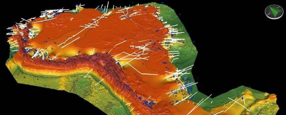
The advancement of computing and software capabilities combined with access to large amounts of data allows the generation of 3D depth frameworks at a size and scale impossible until recently (Figure 6). These can be generated using a range of data, including seismic datasets, well or outcrop information, structural cross-sections and surface geology maps. These subsurface representations identify key stratigraphic horizons within a basin and can be tied to tectonostratigraphic events identified through plate models. The depth frameworks can be populated with predicted or known petroleum system elements and their maturity or reservoir effectiveness can be modelled based on depth estimation, augmented by a knowledge of crustal heatflow and the response of this to different tectonic regimes predicted by the plate model, with surface heatflow provided by palaeoclimate models.
Figure 6: South America regional depth framework highlighting data inputs, including lines of section, outcrop geology, wells, and surface geology data. Halliburton Landmark
Another important source of information regarding the effectiveness of key petroleum system elements is found through the careful use of analogues, particularly valuable in frontier settings. Global analogue databases, such as Halliburton’s Playfinder™ software, make the identification and comparison of relevant analogue data increasingly simple, with geological insight on equivalent stratigraphic horizons easy to identify and extract. Using carefully selected analogues, reliable porosity and permeability trends can be predicted in relation to the depth of likely play elements.
Integrating Models Brings Results
As we have demonstrated, even in areas with poor data control the integration of multiple reasoned geological models can provide a robust assessment of an area’s petroleum potential, whether it represents a stratigraphical or geographical frontier. Such insight is possible through the adoption of an approach where a disparate range of powerful modelling tools is combined to construct a unified conceptual subsurface framework. The models used include those defining the evolution of tectonic plates, those defining changes in palaeogeography and palaeoclimate over time, and those that assess the burial of rocks.
To perform this effectively, a consistent, well-structured, and iterative workflow is necessary, providing the geoscientist with a platform from which to employ inductive and deductive scientific reasoning, test hypotheses, and rapidly update and adapt predictions in a dynamic manner. The result is a time-efficient and well-reasoned subsurface model that culminates in the identification and risking of play concepts.
Acknowledgments:
Thanks to Mike Simmons, Andrew Davies, and Owen Sutcliffe for initial editorial support; and Halliburton for permission to publish this work.


