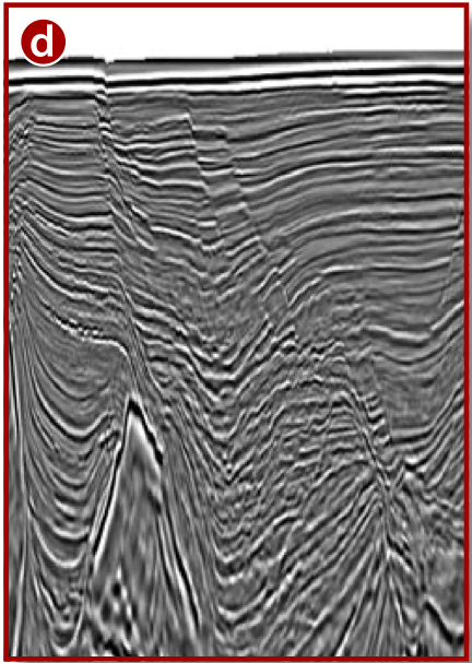
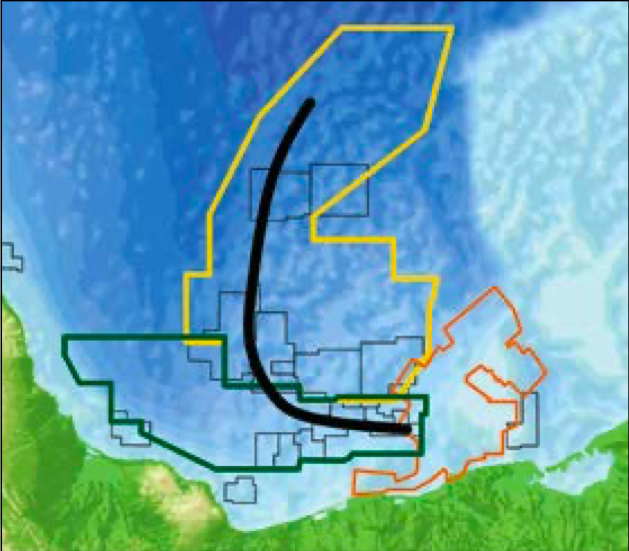
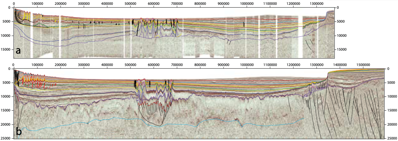
Evaluation of offshore Campeche Salt Basin with progressive data resolution. When Mexico opened its E&P sector, ION took a creative approach to quickly and cost-effectively evaluate this newly accessible area. First, the initial basin framework was established by reprocessing legacy 1970s data from the University of Texas, providing E&P companies with the first regional perspective across the entire basin. Then, using this knowledge, the optimum amount of new 2D data was acquired to address remaining geologic questions on the basin framework. Finally, for evaluation of the earliest rounds in the Campeche Basin, ION partnered with Schlumberger to integrate and reimage 20 legacy 3D datasets using advanced processing technologies and workflows, delivering significant imaging uplift. The combination of new and legacy data integration, geologic-based reprocessing methods and creative partnering enabled fast, cost-effective evaluation of new areas and license round blocks, allowing E&P companies to make informed investment decisions. The Gulf of Mexico has undergone several renewed phases of exploration activity in the last 70 years. During the past decade, considerable focus has been on the deepwater trends of the Lower Tertiary reservoirs, where several billion barrels of reserves have been discovered. When Mexico passed its energy reform, the volume of new and legacy seismic data made available provided the framework for yet another exploration phase which may ultimately yield billions of additional barrels of reserves. As in any basin, the development and understanding of exploration play types, petroleum systems, and future potential is often guided by the quality and availability of data. Prior to Mexico opening its E&P sector, data was limited to proprietary surveys owned by Pemex and legacy academic studies with limited geographic extent and quality. To provide initial insight for E&P companies considering participating in Mexico, ION, in conjunction with the University of Texas (UT), reprocessed over 17,000 km of UT data, creating the first gulf-wide seismic dataset, YucatanSPAN™. This was the first time US subsurface evaluation and interpretation were extended across the entire offshore basin to Mexico. Once new acquisition offshore Mexico was permitted, ION acquired MexicoSPAN™. This program was developed with the tectonic and stratigraphic understanding from YucatanSPAN and was designed to answer regional geologic questions, creating an integrated 2D regional seismic program (see Figure 1). Figure 1: a) Reprocessed YucatanSPAN data was key to imaging Mexico’s deep water prior to country access and for correlating exploration plays into Mexico, b) similar profile to (a) from MexicoSPAN data acquired in 2015. Longer offsets and acquisition / processing techniques provide a much better image of the Mesozoic section and regional basin framework (vertical and horizontal scales in meters). The 2D program ties the entire basin framework together and calibrates the seismic interpretation with over 20,000 subsurface wells, making it possible to map salient time-stratigraphic horizons and understand depositional changes, stratigraphic variation and location of exploration plays across the basin. The regional framework tying the US and Mexico offshore provides a perspective that is unparalleled in any hydrocarbon basin worldwide and highlights multiple exploration play types, providing E&P companies with the opportunity to evaluate and explore the basin in its entirety (Figure 2). Regional frameworks are essential to any basin exploration program to help identify and reduce technical uncertainty and provide context and calibration for creating play-based exploration strategies. It helps geoscientists understand types of additional data that may be required to develop exploration targets that can be risked and ranked based on strategic objectives. Once data requirements are understood, acquiring or purchasing 3D data is typically next. Recent license rounds offshore Mexico (Rounds 1.4 and 2.1) focused on the Campeche Basin, where many 3D programs were acquired for Pemex over the past 15 years. Mexico’s National Hydrocarbons Commission and Secretary of Energy made these legacy data available to help inform evaluation and bidding. Although these data may appear to have limited utility, reprocessing them with the latest techniques has proven to be extremely cost-effective for E&P companies to analyze bid round acreage and detailed play and prospect evaluations. With regional geologic understanding provided by MexicoSPAN, the next exploration step was a 3D seismic program in the Campeche Basin. The Campeche reimaging program is a state-of-the-art reprocessing and reimaging effort of ~82,000 km2 of data across 20 existing 3D surveys. The program is being processed in three phases (North, South and Shallow Water) using an optimal combination of technologies and techniques to maximize data quality and geologic insights for block evaluation. The geologic complexity and variability require consistent, cuttingedge workflows to maximize bandwidth, producing data with strong low frequency content for subsalt areas and high resolution data for non-salt areas. After just the initial Fast Track phases, the reimaging program is demonstrating significant imaging uplift. Broadband preprocessing coupled with high resolution steep dip RTM and Kirchhoff imaging algorithms is producing superior data ideal for prospect identification. In three to five months, the processing and interpretation team delivered a complete volume with updated seismic velocities and allochthonous salt interpretation for velocity model building, a step-change in turnaround time to deliver key insights before the license round. Iterative sediment and salt flood RTMs are also provided to deliver the detail and quality required for a more thorough evaluation. The challenge to reprocess and reimage 82,000 km2 of data from 20 separate surveys and deliver in a timeframe useful for the licensing round cannot be underestimated. The project’s scale and completion timeline would not be possible without the pre-existing regional framework understanding and close integration between processing, interpretation and imaging personnel. Multiple iterations and continual calibration occurs in ‘ad hoc’ team discussions. In an unprecedented achievement, the first 20,000 km2 (VTI, velocity model) were delivered in six weeks. The most recent Enhanced Fast Track (42,000 km2) was delivered in three to five months starting from field tapes, complete with velocity models (top and base of salt interpretation) and 30Hz RTM. Figure 3a shows legacy data from the Yoka survey in the Campeche North salt basin. The legacy beam migration helps to identify allochthonous salt and the strata in adjacent mini basins, however, base salt, steep dipping thrusted fold geometries, and autochthonous salt are not well imaged, making the interpretation and understanding of the kinematic evolution of salt difficult. Figure 3b is the same line from the Enhanced Fast Track volume. Note the base salt for both allochthonous and autochthonous is well imaged, the stratigraphy of the subsalt areas has higher frequency and better resolution, and the steep flanks of folds, mini-basins and salt canopies are clearly imaged. The foldout seismic section (shown above) is a composite Fast Track line across Campeche reimaging North and South. The Campeche reimaging program provides a higher resolution image and provides geoscientists with a commercial tool of choice, allowing companies to evaluate, risk and rank a portfolio of opportunities for current and future license rounds. In some instances, it provides enough information to drill exploration wells. In areas where salt geometries are more complex, it can be used as a screening tool to evaluate the need for data with greater azimuthal aperture. While exploration strategies and approaches vary by company, a consistent requirement is to understand the basin framework to position the company in areas that match strategic objectives. Companies should focus on the most cost-effective methods to evaluate and access acreage with the greatest potential. Using the basin scale approach, ION has pursued understanding hydrocarbon basins globally by utilizing the latest data processing technologies and workflows to integrate new and existing data that focus exploration programs from the regional context to a prospect. Collaborative partnerships with the University of Texas on YucatanSPAN and Schlumberger on the Campeche reimaging program are excellent examples of providing programs in a timely and cost-effective manner.
Refining exploration opportunities in Mexico
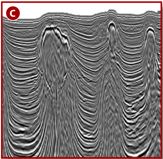
 Composite line across Campeche reimaging North and South programs from the Enhanced Fast Track volume, highlighting improved imaging across the entire survey.
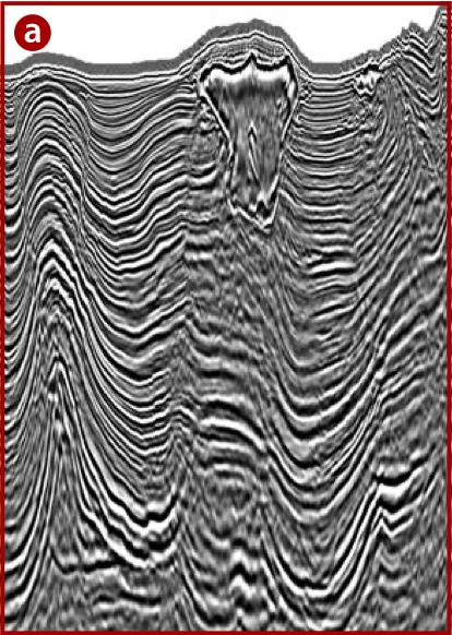

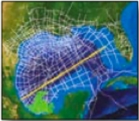
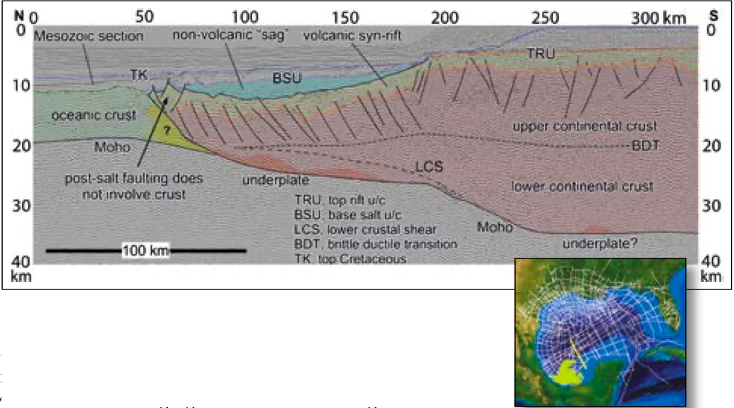
Regional framework for GoM
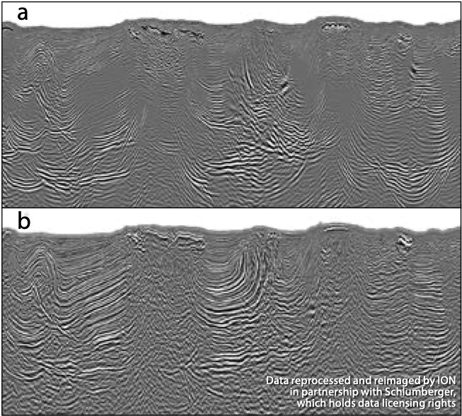
Reprocessed 3D data
Cost-effective methods
Related Articles


