What Lies Beneath the Deepwater Tano Basin?
Hunting for Jubilee-like prospects in Côte d’Ivoire
Boosted by recent discoveries, Côte d’Ivoire has seen renewed interest in its deepwater offshore basin over the last few years. Up until 2011, not a single well had been drilled beyond the 2,000m water depth line of Côte d’Ivoire, but ten wells have been drilled over the last three years. Several technical discoveries, which are not necessarily commercial for the time being, were made, including Saphir in Block CI-514, Morue in Block CI-516, Buffalo in Block CI-205, Paon/ Autruche in Block CI-103, Ivoire in Block CI-100 and Capitaine East in Block CI-101 (Figure 1).
Nearer shore, the basin has been explored since 1972 when the first offshore well IVCO-1 was drilled. Subsequent discoveries were made that highlighted the presence of a working hydrocarbon system in the Lower Cretaceous syn-rift/transition sequence, but it was not until the new play-opener Jubilee discovery in 2007, found in Upper Cretaceous turbidite sands in the adjacent deepwater Tano Basin in Ghana, that deep offshore exploration started to take off. Soon after, two other Ghanaian oil discoveries were made: Tweneboa (one of the top 10 discoveries in 2009, according to IHS) and Enyenra (a top five discovery in Africa in 2010) in the vicinity of Jubilee. The oil was typically found in stacked turbidite channels, levees and splays. Exploration then shifted westwards into Côte d’Ivoire when the first ultra-deepwater well was drilled in 2011.
Two Working Petroleum Systems
The two main exploration phases that have taken place in Côte d’Ivoire (from shallow to deep water) have highlighted the existence of two major working petroleum systems. These are, firstly, a Lower Cretaceous syn-Atlantic rift system, which has been mainly explored and developed near shore so far. This petroleum system includes Aptian to lower Albian continental reservoir sands and source facies of similar age deposited in lacustrine to swamp settings, with mainly structural trap styles (i.e. fault blocks and compactional drapes). The second is a Late Cretaceous petroleum system found in the deepwater acreage, fed by a prolific Cenomanian-Turonian marine type II source rock with predominantly Turonian to Maastrichtian turbiditic reservoir sands, where a significant component of the trapping mechanism is stratigraphic in nature (i.e. pinch-out traps and local facies variations).
This article focuses on an area of 4,400 km2 covering blocks CI-527, CI-528, CI-529 and CI-530 in the Ivorian part of the Tano Basin where no drilling has yet taken place (Figure 2). In 2014 CGG undertook a multi-client BroadSeis™ 3D seismic survey to cover this unexplored area, which has provided the basis for a geological review.
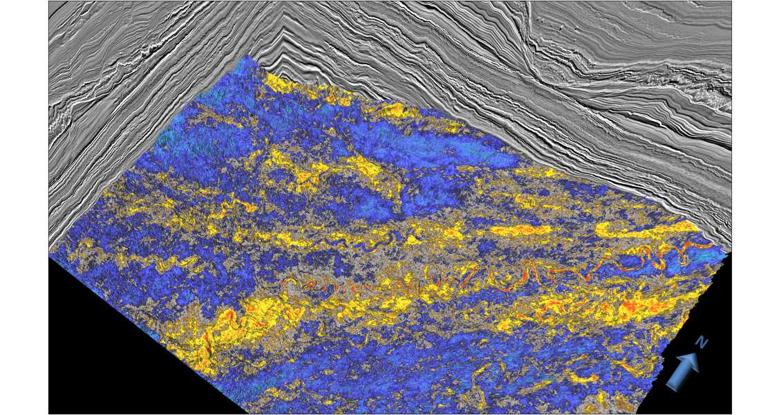
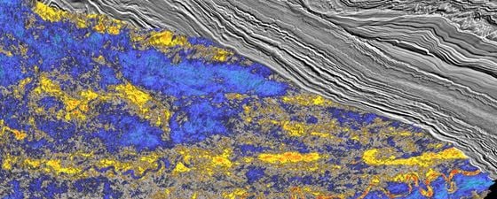
Figure 2: Amplitude extraction over the top of TC1 showing details of the channels’ depositional patterns. (CGG)
Stacked Turbidite Systems
A full 3D seismic interpretation was carried out to reveal the geometry of several key stratigraphic horizons in the area, namely Top syn-rift, Late Albian, Mid Cenomanian, Late Cenomanian, Top Turonian, Top Coniacian, Top Campanian, Top Paleocene, Oligocene unconformity and the seabed. Calibration of the age of these horizons was carried out by tying nearby well data with other CGG multi-client 2D and 3D seismic data in the area. This interpretation includes top and base of three main turbidite complexes (TC1, TC2 and TC3) identified through the Upper Cretaceous section, ranging from Santonian to Late Campanian age (Figure 3). Although younger than the Turonian-aged Jubilee-type reservoirs also found in Tweneboa, Enyenra and Autruche, these turbidite deposits are interpreted as analogous in terms of depositional environment: proximal slope channels and levee deposits with similar reservoir properties.
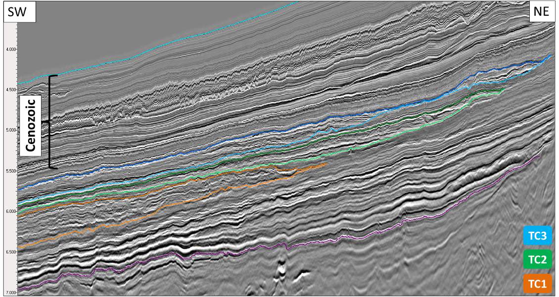
Figure 3: Interpreted seismic section highlighting the three major turbiditic complexes TC1, TC2 and TC3. NB: The purple horizon represents Top Albian. (CGG)
This has been interpreted on seismic data using amplitude extraction methods, as illustrated in Figure 2. The interpretation of the three Upper Cretaceous turbidite complexes clearly shows a north-east to south-west orientation with sediments feeding from Ghanaian and Ivorian coasts into the deep Tano Basin. These sediment-rich turbidites flowed southwards until they reached the Côte d’Ivoire-Ghana Ridge (CIGR), which then diverted the flow towards the south-west. The CIGR forms the north-eastern tip of the 2,000-km-long Romanche tectonic transform lineament which ties to the Mid Atlantic Ocean Ridge, delineating the southern limit of the Tano Basin.
The deepest turbidite complex (TC1) represents an outer slope fan lobe, deposited in a lenticular down-dip geometry that is seen pinching-out towards the palaeo-slope. Internally, this body shows onlapping reflector geometries with a number of small-scale slump features. In Figure 2, a maximum amplitude attribute extraction performed over the top of TC1 shows a multi-phased system of meandering sand channels of Santonian age. Similar turbiditic sand deposits found at Jubilee in Ghana have shown good porosities averaging 17–22% and permeabilities of 100–3,000 mD (D. Hanley et al., 2009).
TC2 and TC3 represent two large turbiditic systems dominated by multiple lateral channel incisions, vertical channel migrations and associated levees. The internal architecture of the sand bodies shows widely developed pinch-outs onlapping towards the near-Santonian and Campanian palaeo-slopes.
These three turbidite complexes are each separated by thick intervals of aggradational deposition of sediments, suggesting mud-dominated depositional facies. Furthermore, the seismic interpretation reveals the presence of potential internal seal units within each turbidite complex (Figures 3 and 4) with local deposition of marine mud layers at times when the turbiditic system was starved of sands.
In terms of hydrocarbon trapping mechanisms, TC1 would be described as a pure stratigraphic pinch-out trap, whereas structural mapping of top TC2 and TC3 shows the potential of combined stratigraphic and structural trap styles (Figure 4).
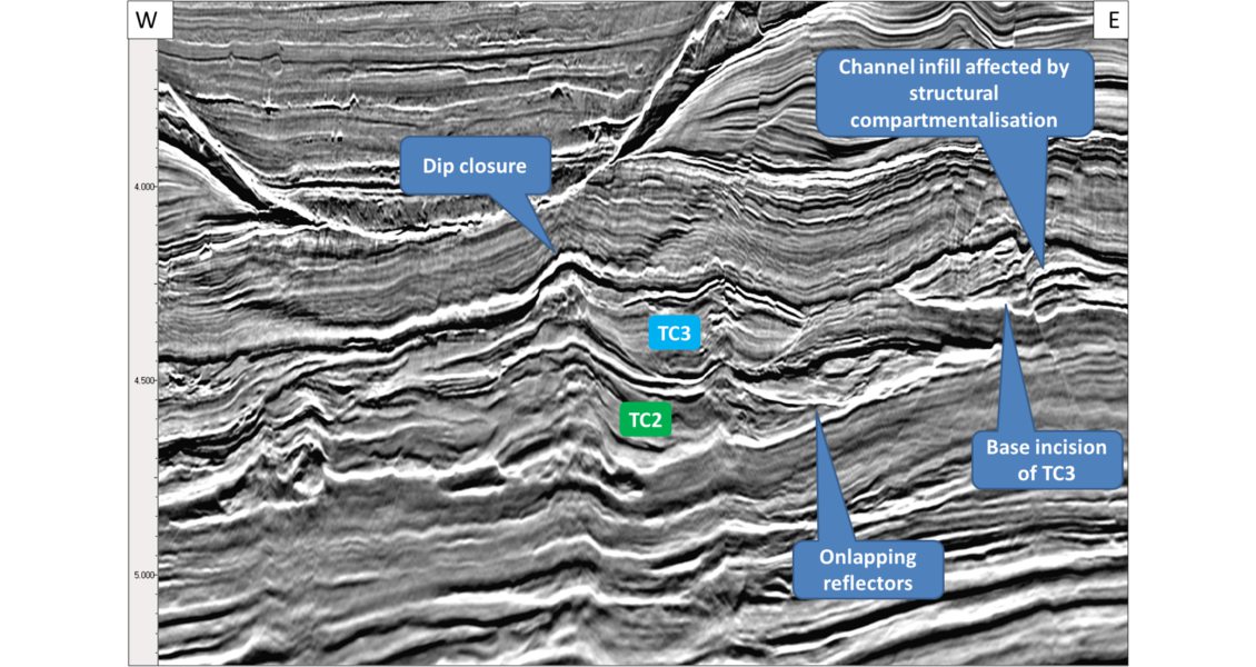
Figure 4: Details of the internal architecture and stratigraphy of TC2 and TC3. (CGG)
The Influence of Volcanic Activity
At depth below the Upper Cretaceous turbidite systems, the seismic interpretation has revealed the presence of volcanic mounds surrounded by multiple sills and dykes (Figure 5). These intrusive volcanic complexes are exceptionally clear based on the combination of the broad bandwidth and advanced imaging: low frequencies penetrate deep below the sedimentary overburden and help reduce spurious sidelobes of the main seismic reflections, which in turn allow a clear pick of top and base of individual bodies of volcanic intrusions. Three main volcanic centres have been identified, aligned on a south-west to north-east trend parallel to the CIGR trend. In addition, when comparing the shallowest intrusions with the age of the encasing sediments, it is estimated that the relative age of the volcanic activity is Albian to Cenomanian. These combined observations suggest that the volcanic activity was related to the beginning of the drifting phase of the Atlantic Equatorial Margin. Although the subject of speculation, volcanic rocks of that age had never been recognised in the basin before the acquisition of this new 3D seismic survey. The nearby Saltpond Basin in Ghana does show evidence of Jurassic volcanism (USGS Bulletin 2207-C, 2006) which could be related to the onset of block faulting, but nothing in the Albian-Cenomanian.
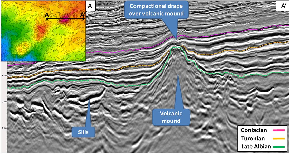
Figure 5: Details of a volcanic complex developed during the Albian-Cenomanian age. (CGG)
The presence of volcanism in the area and its age and distribution may have an impact on different elements of the petroleum systems, including seal and reservoir quality, trapping mechanism, heat flow distribution and local source rock maturation. One clear impact on hydrocarbon prospectivity is that these volcanic mounds can provide structural traps by compactional draping of the overlying layers of sediments, including Upper Cretaceous turbidites, as illustrated in Figure 5. Another more speculative impact could be the increased heat flow produced by prolonged igneous activity: this may have potentially altered the local maturation of both the Apto-Albian continental and the Cenomano- Turonian marine source rocks by bringing them into higher-maturity temperature windows.
Large Buried Canyons Revealed
The 3D seismic data show high-resolution details of the shallow subsurface where deeply incised canyons with sand-filled channels can be observed. Our analysis reveals the existence of three major canyon system successions: the oldest being of Miocene age, the middle one interpreted to be of Pliocene age, while the youngest was initiated in Pleistocene times and is still active today (Figure 6). Its topographic relief is noticeable on presentday bathymetry with dimensions of over 500 metres in depth, several hundred to 1,000 metres in width, and a length of several tens of kilometres. This large deepwater canyon appears to be on trend with the well-documented Trou-Sans-Fond submarine canyon present on the Ivorian continental shelf (Figure 7). The intrusive volcanic complexes are exceptionally clear based on the combination of the broad bandwidth and advanced imaging. This is proof of its extension further into the ultra-deepwater of the Atlantic Ocean, several hundred kilometres from the coast.
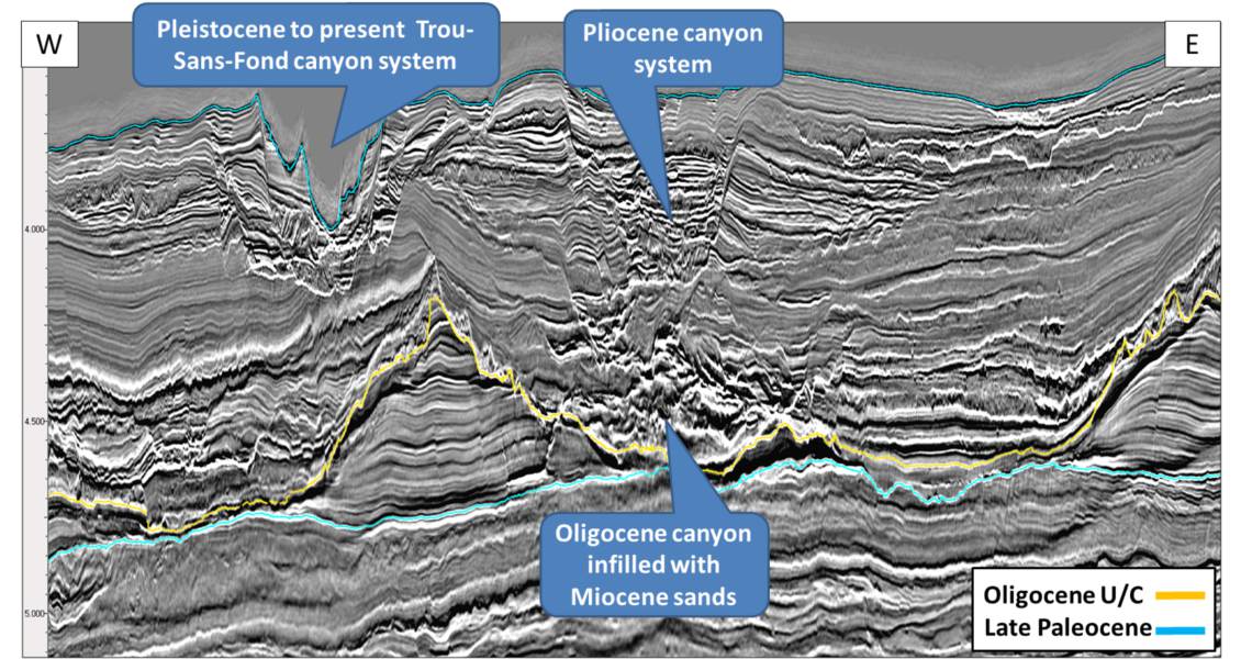
Figure 6: Detail of the widely developed Paleogene canyon systems. (CGG)
As illustrated in Figure 7, these shallow palaeocanyon systems are filled with high seismic amplitude channel sands, which can be easily mapped with Acoustic Impedance or RMS amplitude attribute extractions. The broad frequency bandwidth of the seismic data highlights details of the complex stacking patterns, truncations and internal geometries of these channels. Mapping of these anomalies is not only important for the identification of potential prospective features in the Tertiary section; it also brings high-value information to plan a drilling site and avoid geological hazards which may conceal a deeper exploration target.
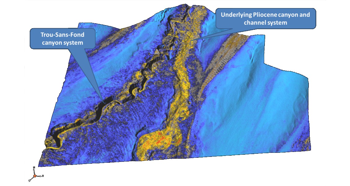
Figure 7: 3D view and amplitude extraction of the Paleogene canyon and channel systems highlighting sand distribution. (CGG)
Hunting Jubilee-like Prospects
Reviewing this new 3D seismic volume in the Ivorian deepwater Tano Basin has brought to light the presence of well-developed Upper Cretaceous turbiditic systems, up-dip of the main source rocks in the area, which are similar to the Turonian sands found at Jubilee and surrounding fields. The trapping mechanism is expected to be mainly stratigraphic with a partial structural component. This study has also highlighted the presence of Albian-Cenomanian volcanic intrusions and mounds underlying the potential reservoir sands, which emphasises the structural component of the trapping mechanism. Ongoing work now focuses on the analysis of Amplitude Versus Offset signature in order to ascertain the presence of trapped hydrocarbons and increase the chance of success on potential prospects.


