
The Great Australian Bight An Emerging Global Hotspot
Scale and ambition are accurate words to describe new oil exploration underway in the Great Australian Bight, but they do not quite do it justice.
To get a real sense of how this underexplored region is suddenly a hotspot, consider that six explorers —including half of the world’s largest producers – are racing ahead with 3D seismic surveys over more than 40,000 km2, an area the size of Switzerland. And that is even before the first well is drilled.
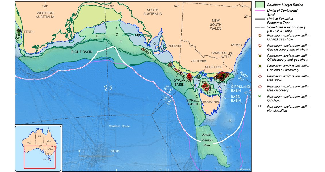
The Bight Basin is an almost continent-wide feature on Australia’s southern margin, spanning 2,000 km from Albany in Western Australia to Port Lincoln on South Australia’s Eyre Peninsula. This entire stretch of coastline is almost uninhabited and is best known as the location of the Nullarbor Plain and the world’s longest stretch of railway without a single bend.
The Bight Basin is seriously underexplored. (Source: Geoscience Australia)
Unlike West Africa or the Gulf of Mexico, the Australian coastline today bears no sign of the giant river systems that once fed the Bight delta. A recent study of zircons in drill core by the Australian School of Petroleum suggested there might have been two river systems – an Amazon-like river with a catchment that spanned most of Australia in the Early Cretaceous, followed by a system of multiple, fast flowing rivers which coincided with rapid uplift in the last stages of rifting between Australia and Antarctica in the Late Cretaceous.
The Ceduna sub-basin, the target of most of the new exploration activity, is the largest of three major sub-basins and accounts for the obvious delta feature seen on bathymetry. To the west and east are the Eyre and Duntroon sub-basins respectively. These are older parts of the Bight Basin that were generally not buried by the sedimentation in the Ceduna sub-basin. Earlier explorers targeted the Duntroon sub-basin in the 1980s and early 1990s.
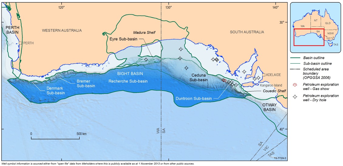
The Bight Basin and sub-basins. (Source: Geoscience Australia)
Lack of Exploration
BP leads the new wave of exploration and has been uncharacteristically bullish in its public statements. Andy Holmes, President of BP Australasia, told The Australian newspaper in August that the Bight was most likely one of BP’s top five prospects worldwide. “That territory could be something like the Niger Delta or Mississippi Delta, so it’s of interest to the world, not just Australia and BP. We don’t know yet, but it could be that big.”
The Bight has always looked like a great target for oil explorers, who have been lured by the hope of discovering Australia’s second great oil province (after the Bass Strait, which lies between the State of Victoria and Tasmania). Bathymetry shows a massive delta covering almost 130,000 km2, while 2D seismic back in the 1970s and 1980s established more than 15 km of sediment thickness. But only 12 wells have been drilled since exploration began in the 1970s, the most recent more than a decade ago, when Woodside Petroleum drilled Gnarlyknots-1 in 2003. The well failed to reach its target zone in the deeper lobes of the delta because of fierce weather blowing straight up from Antarctica.
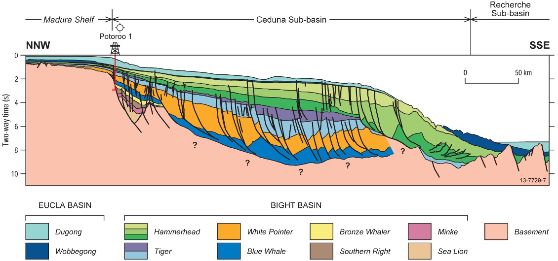
Cross-section across the Ceduna Sub-basin showing inboard Jurassic half-graben and thick pre-breakup (Blue Whale to Tiger supersequences) and postbreakup (Hammerhead supersequence) deltaic-marine successions. (Source: Geoscience Australia)
The remote location of the Bight, its deep water and the risk of violent storms for at least half of the year are major causes of the lack of historical exploration. However, the overriding reason was poor confidence in the presence of petroleum systems, and particularly source rocks. In 2007, the Australian government’s agency for promoting offshore exploration, Geoscience Australia, planned to address the source rock risk with an ambitious seafloor dredging survey. Using historical 2D seismic and high-resolution swath bathymetry, the agency identified a number of locations where submarine canyons on the edge of the continental shelf should expose inferred source rock horizons
Sampling Canyons
The practice of dredging the slopes of seafloor canyons had been developed and fine-tuned by Geoscience Australia over the previous 20 years. It had already been used successfully to generate a picture of the stratigraphy of the Bremer sub-basin at the western end of the Bight. The Bight dredging project was led by Geoscience Australia’s senior geologist, Jennie Totterdell. After many months of planning, the difficult task of sampling the walls of submarine canyons at water depths in excess of 2,000m was executed without problems by a crew aboard the government-owned RV Southern Surveyor. It was not until preliminary analysis of the samples was completed six months later that Ms Totterdell knew they had hit the jackpot.
“In one particular canyon that had incised to a level where we could dredge samples of the right age rock, we obtained a suite of about 11 samples of mudstone that proved to be an organic-rich, liquids-prone source rock,” she explained. “The more analyses we did, the better it looked. We soon established that these Cretaceous source rocks were right on the Cenomanian-Turonian boundary, which is one of the great anoxic events and a major global source rock. We no longer had to hypothesise about source rocks because there was one we could actually put our hands on. That made a big difference to how explorers perceived risk and prospectivity in the basin.”
The results of the survey and Geoscience Australia’s analyses were released as part of the Australian government’s annual acreage release in June 2009 with the hope of reviving interest in the Bight, which had languished now for two years without a single exploration permit. The response was a dramatic vindication of the precompetitive work, with BP announcing in January 2011 it had won four permits with a record-breaking six-year work programme worth $AUD1.41 billion. This included an 11,000 km2 3D seismic survey, the biggest ever conducted in Australian waters. BP subsequently farmed out a 30% interest in its four areas to Statoil, laying off some of the risks and the costs of its commitment to a four-well deepwater drilling campaign that will begin in 2016, using a purpose built deepwater rig.
Six months after the award of acreage to BP, Bight Petroleum, an unlisted junior explorer based in Adelaide, announced it had secured two permits at the eastern end of the Bight in the Duntroon sub-basin. The company had been working quietly to acquire permits since well before the 2010 acreage release, based on the enthusiasm of a local consultant geophysicist, Dr Peter Boult.
Fifteen months after the award to BP, the revival of activity in the Bight had developed into an exploration rush, supported by new acreage released by the government. Chevron announced it had secured two areas by committing to spend at least $AUD486 million over the next three years, including 21,000 km2 of 3D seismic and four exploration wells. In the same round of acreage approvals, Adelaide-based Santos and US independent Murphy Oil were granted a permit based on a $AUD50 million seismic programme of 2D and 3D seismic.
Bight ‘Unique’
 The Great Australian Bight is characterised by a unique geology located in a pristine natural environment. (Source: ©SATC/Neale Winter)Ms Totterdell believes the Bight is unique both in Australia and globally, which is one of the reasons it has created such a high level of interest. “The age and the depositional environment of the source rocks have no good analogue anywhere in the world. In Australia, for example, the main source rocks we have identified in the Bight are marine in origin and of Albian and Cenomanian-Turonian age. That’s unique for Australia. These rocks have no relationship with those in our most prolific petroleum provinces, the North West Shelf and the giant oil fields in the Bass Strait. At the eastern end of the southern margin, the offshore Gippsland Basin between Victoria and Tasmania has Late Cretaceous to Cenozoic source rocks that are entirely different to the Bight.”
Looking further afield, analogues are still hard to find. “We know early Cretaceous marine source rocks account for a significant proportion of global oil production, but they are found in different depositional environments to the Bight. The analogies with the regions like the Niger Delta are only useful when you are looking at the structural geology. We only ever used the Niger Delta and Orange River basin as structural analogues. These are like the Bight Basin in that they are large prograding deltas, with big growth faults. Further outboard in the basin, the extensional movement of those faults is compensated by thrust faults, which creates a thrust belt at the edge of the basin. That’s similar to the architecture on the Niger and many large Cenozoic delta systems in the world. But we are not talking about a Cenozoic system in the Bight, it’s Cretaceous — a good 50 to 100 million years older. There was a greenhouse climate and different organic material contributed to source rocks, whether they are coal or marine algal material. So you can’t compare them directly to something like the source rocks in the Niger Delta or the Gulf of Mexico or the Mackenzie Delta. The petroleum systems in the Bight are unique.”
Ms Totterdell said that another reason for the level of interest in the Bight was the likelihood of a wide variety of source rocks. “In the Ceduna sub-basin you have 15 km or more of sediment that developed over 100 million years. You have everything from lacustrine source rocks in the Eyre sub-basin to the marine Albian and Cenomanian-Turonian source rocks in the Ceduna sub-basin. The big deltas that prograde out include coaly facies and associated mud rocks, which have source potential as well. It’s just such a wide variety of potential petroleum systems.”
The paucity of drilling, especially in the Ceduna sub-basin, means that while explorers are confident about source rocks, much more information remains to be gathered to understand the Bight’s petroleum systems. “There are still questions about the distribution of reservoir rocks and seals, and the nature of the important facies for the petroleum systems. Many of these questions will not be answered until wells are drilled, although the level of knowledge is growing exponentially with the amount of 3D seismic being acquired. The amount of data that is available now compared to when we did our study is just stunning. And, unlike old campaigns where they were drilling poorly-imaged structures, today’s 3D seismic is so much more sophisticated. Explorers can use a range of amazing geophysical techniques on that data to get a handle on the lithologies and understand the nature of reservoir and seal rocks,” Ms Totterdell said.
Environmental Issues
Exploration in the pristine waters of the Bight has not been without controversy, with environmental groups mounting noisy anti-seismic and anti-drilling campaigns. BP was granted its acreage in the immediate aftermath of the Deepwater Horizon accident in the Gulf of Mexico and had higher-than-normal conditions placed on its permits. Activists were still not satisfied, but the Australian government and its new offshore drilling regulator, the National Offshore Petroleum Safety and Environmental Management Authority, have been meticulous in obtaining all possible safeguards and clearing a path for the first wells in 2016.
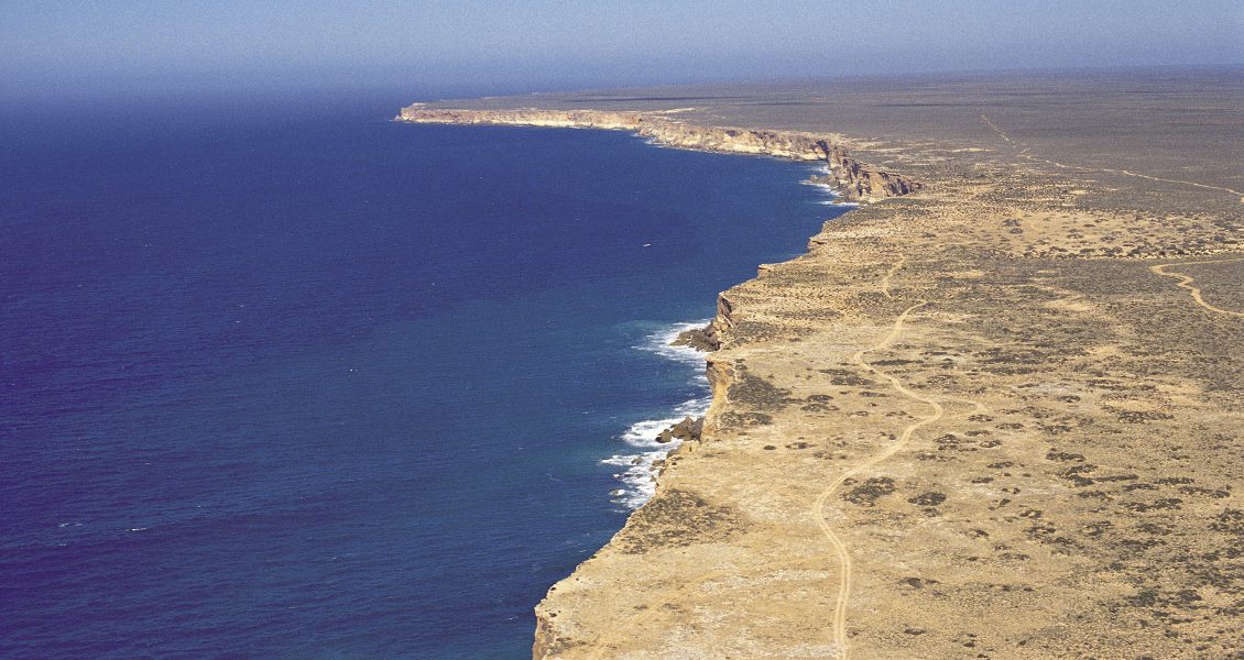
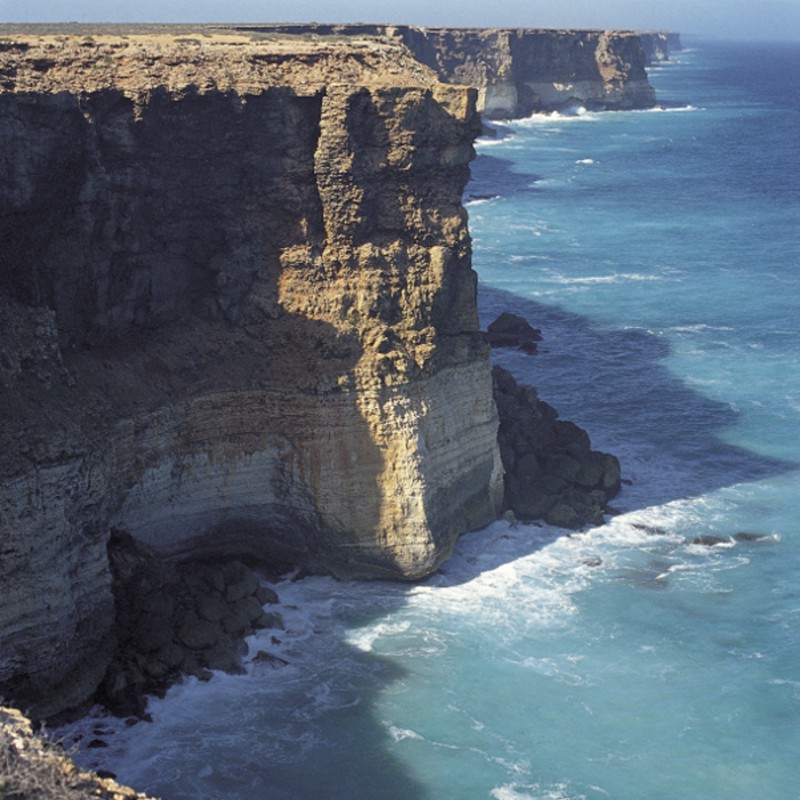
Hundreds of kilometres of impenetrable cliffs help to make the Great Australian Bight a remote area for oil explorers. (Source: ©SATC/Neale Winter)
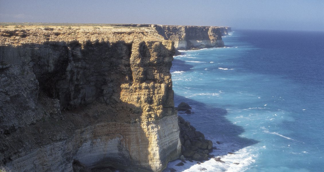
Hundreds of kilometres of impenetrable cliffs help to make the Great Australian Bight a remote area for oil explorers. (Source: ©SATC/Neale Winter)
Ironically, the smallest player in the region, Bight Petroleum, has been hardest hit by environmental opposition. The company’s acreage is located about 100 km from inhabited coastline, including the foodie and tourist haven of Kangaroo Island. In June, the company finally received environmental approval for a 3D survey, almost three years after it began consultation. The company is now seeking a joint venture partner to help fund its $AUD67 million work programme, and has no shortage of interested parties. More than 20 explorers have signed confidentiality agreements to evaluate a farm-in, including some of the world’s major producers who are not already in the central part of the region.
Bight Petroleum’s largest prospect, Price, is a four-way dip closure covering more than 130 km2. Managing director, Matthew Philipchuk, said Price could hold more than 5 Bb of recoverable oil. “One of the advantages we have compared to where the majors are exploring in the central Bight Basin is we do have shallow water targets. We also believe we have the advantage of an overlying wedge of Tertiary sediments that is missing in the central Bight. We have some great evidence the source kitchen in our permits has been turned back on and that we are exploring a current-day petroleum system. That means we have fresh hydrocarbon charge and greater potential for oil accumulations, as well as sweeter oil than in the central Bight.”
Opportunities
For explorers wanting to join the action in the Bight, there are still a number of opportunities aside from the least risky path of a joint venture with one of the existing players. A new area (W14-19) was released in May for work programme bidding, covering more than 30,000 km2 of the Eyre sub-basin. Ms Totterdell said the area is centred on a Jurassic extensional depocentre and is a different play to the other permits in the Bight. However, there is evidence of a working petroleum system from Jerboa-1, the only well drilled in the permit. “Fluid inclusion studies by the CSIRO and Geoscience Australia did show that Jerboa-1 had drilled a breached accumulation, so we know that petroleum was generated and migrated into a trap that subsequently failed. We can also find these Jurassic depocentres beneath the Ceduna subbasin, but they are more deeply buried there and in many cases the source rocks are likely to be overmature. In the Eyre sub-basin, the chances of success for the Jurassic play will be better.”
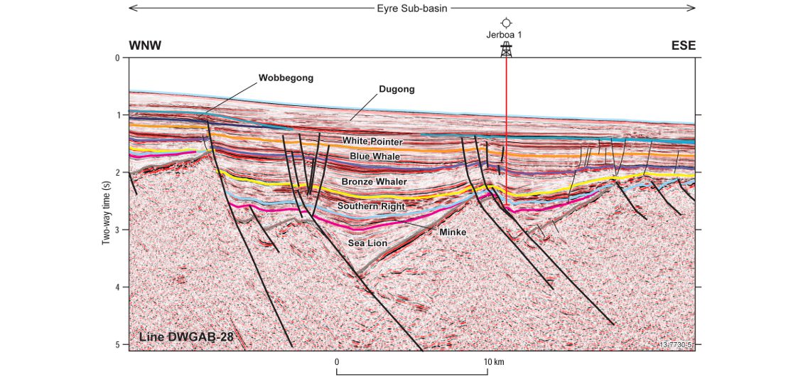
Seismic line across Release Area W14-19 in the Eyre Sub-basin. Lacustrine source rocks in the Jurassic- Early Cretaceous rift section are interpreted to be the source of a palaeo-oil column in Jerboa 1. (Source: Geoscience Australia)
In the context of the renewed exploration activity in the Bight Basin, the Australian government might consider the release of new acreage in coming years, but the least complex areas are certainly already taken. For most industry players, it might now be a case of wait and see what the first wells in 2016 bring. But if BP’s confidence is validated, the entry terms are likely to be much more expensive.


