
Gaining a Regional Perspective
What has happened in recent years in the Caspian region, how has it changed – and what is preventing companies from operating here?
In 2010, the international scientific consortium Geology Without Limits was established to study the development of new geodynamic models of sedimentary basins (see GEO ExPro Vol. 9, No. 3). One of its founding principles is that geology knows no political boundaries – and a new study of the Caspian region found some interesting obstacles to overcome.
Relying upon the experience of many years in conducting international programmes in offshore areas of various states, the organisation has identified several factors restricting regional geoprospecting operations in marine offshore areas which are especially relevant in the Caspian Sea. These include political, geographical and geological limits, as well as economic and financing issues and the gap in technological know-how between countries. These challenges are compounded by the complex and lengthy process of coordinating the work scope and obtaining permissions from various governmental and supervisory agencies, which often leads to derangement of time schedules and work performance.
Many world giants of the petroleum industry, such as Schlumberger and BP (Anglo-Persian Oil Company), started out in the Caspian region, and by the beginning of the 20th century it was the centre of petroleum geology, with the world’s best geologists and the latest technologies involved. Hydrocarbon resources were a powerful catalyst in the development of this region, yet now these same hydrocarbon resources are the main obstacle to progress. The region of the Caspian Sea always was a complex and inextricable tangle of contradictions between participants in activities in this region; after discovering mineral resources, especially hydrocarbons, relations became yet more strained.
Let’s look at these issues in more detail and work out what is preventing companies from operating in the Caspian.
Territorial Disputes
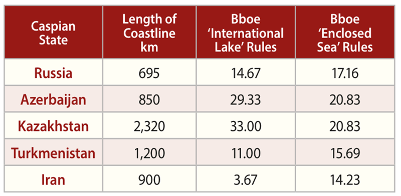 Distribution of hydrocarbon reserves depending on legal status of the Caspian Sea.The territory of the Caspian region is under the jurisdiction of the five Caspian States: Russia, Kazakhstan, Turkmenistan, Azerbaijan, and Iran. The state borders between the countries are not consistent with the natural limitations which determine petroleum geological and landscape-climatic zonation, like geological features, geodynamic and morphological structures or fluid systems. This dramatically complicates efficient use of natural riches in the region and the solution of environmental problems.
Since the breakup of the USSR, the main barrier for conducting regional operations has been the partition of the Caspian Sea, which, as an inland water body, is not automatically subject to the international law of the sea. Territorial disputes and different approaches to the principles of delimiting the water and air space remain the main impediment to solving the status of the Caspian Sea. The issue is vital as not only use of its bioresources depends on it, but also its hydrocarbon riches and their protection and exploitation. Only three coastal states – Russia, Kazakhstan and Azerbaijan – have signed an agreement on delimitation of the seabed, partitioning 64% of the Caspian, so Kazakhstan obtained 27%, Russia 19%, and Azerbaijan 18%. For Iran, a share of 14% is suggested, but Tehran, supported by Turkmenistan, lays claim to 20%, transferring the boundary 80 km north of the line along which the Iran-Soviet maritime boundary was drawn.
 The seat of the trouble – territorial disputes. Photo Credit: Geology Without limitsDepending on how the Caspian Sea is divided, the amount of hydrocarbon resources falling to the share of individual countries changes significantly. The value in dispute is high, especially for Iran, with estimates of oil and gas resources differing by 150% for the country, depending on the division used. As a result of these disputes over territorial limits, there have been displays of military force and military exercises by the states in the Caspian Sea, giving rise to concerns about the destiny of the region.
The unsolved legal status makes it impossible for companies to conduct regional investigations or to invest in geoexploration operations on known fields. A solution is only possible with the involvement of the five Caspian states and through the development of mutually profitable scientific regional programmes in the Caspian Region.
Geology Without Limits has the support of all the Caspian states for the new regional programme. All the geological services of the countries in question are extremely interested in new regional data which will make it possible not only to reconsider the structures of the existing fields but also to reveal new prospects.
Extending the Boundaries
The issues affecting geographic limits are a lack of scientific cooperation, plus outdated geological information, not compliant with contemporary technical standards and often contradictory. Most regional geoprospecting operations were conducted during the time of the USSR, when the foundations for the key concepts of the regional structure of the Caspian region were identified. After the breakup of the USSR, for economic and political reasons, the newly formed independent states did not give due consideration to regional investigations, leaving subsurface users to rely either on new data obtained within a particular field, or on old regional data. The exchange of new data among state geological institutions and the reconciliation of models practically ceased, resulting in the emergence of a multitude of unilateral geological models discordant with each other. This fragmentation gave rise to uncertainty over the prospectivity of the Caspian region.
 Location of assessment units (AU) in the Caspian Sea area; as can be seen, the basins of the Caspian area do not follow geographical boundaries – nor should research. Photo Credit: USGS Energy Resources ProgramAll geologists now admit that a region should not be limited by political and geographic boundaries and any basin should be investigated as an organic entity. In the last decade, many leading geologists have come to understand that the Caspian region has been subject to recent sedimentation inside the Caspian catchment basin, which comprises the Caspian Sea offshore area, the Precaspian Lowland, the Ustyurt Plateau, and the lowland plains of western Turkmenistan and Azerbaijan.
However, taking into consideration that this region could be a main source of hydrocarbons for Western and Eastern Europe, the boundaries could be considerably extended. They should be drawn along the perimeter of the petroliferous sedimentary basins of Palaeozoic and Meso-Cenozoic age that are situated inside the major area of downwarping of the basement in the central sector of Northern Peritethys (at the periphery of the East European Palaeozoic continent exposed to the Palaeo-Tethys ocean).
A solution to the problem of discordance in the models in the Caspian countries and extension of the limits of investigation is only possible through international cooperation based upon new regional data, relying on all exploratory work undertaken during the latest decades.
Sharing Financial Burden
Any major project is underlain by an economic justification. Conducting a regional investigation will require coverage of the entire basin as a single entity; the countries of the Caspian do not conduct regional surveys within their respective offshore areas, partly because of the cost, but also due to the futility of such surveys over small areas. Fulfillment of a large-scale regional programme will require big financing, especially in view of the wide range in water depth – from 5m in the north to 1,020m in the south.
Conducting regional investigations within the framework of an international scientific consortium makes it possible to solve the problem of covering the entire basin as a single entity.
 Location of assessment units (AU) in the Caspian Sea area; as can be seen, the basins of the Caspian area do not follow geographical boundaries – nor should research. Photo Credit: USGS energy resources programOperations are undertaken throughout the offshore basin and adjacent onshore areas, using the same technology, looking at exploration maturity, peculiarities of structure, and prospects for the basin. Working within the consortium makes it possible to raise funds from several sources for sharing the financial burden among participants of the programme, thus making it possible for countries to obtain unique information for the entire region under investigation.
Undoubtedly, regional surveys should also be of interest to oil companies. Quantitative estimates of initial resources of the Caspian region made by different petroleum companies have varied widely, differing by a factor of two and more for some provinces. The reason for discrepancies in estimates of the resource potential are mainly associated with differences in opinions over which part of the section of the sedimentary cover is to be considered as potentially prospective.
High and Low Estimates
Low estimates of resource potential result if only the part of the section of the sedimentary cover that is well studied, with field-proven exploration operations, is taken into account for the analysis. As a rule, these are deposits of the ‘platal’ complex occurring at depths up to 5 km. High or optimistic estimates take into consideration the resource potential of the entire section of the sedimentary cover, including deep (>6 km) horizons of the ‘platal’ complex, and also that of deposits of the ‘pre-platal’ and ‘folded’ complexes with unclarified prospects, but evaluated by many researchers as potentially prospective. Thickness of such rock masses in the central, most subsided parts of the Precaspian, Terek-South Caspian, Ciscaucasian-Mangyshlak and Aral-Caspian provinces reaches up to 15 km.
By optimistic estimates, the subsurface of the Precaspian, Ciscaucasian-Mangyshlak and Terek-South Caspian provinces retain a considerable unexplored resource potential, almost two-thirds of the initial resources – about 660 Bboe in place, comparable with the resource potential of the eastern and northern regions of Russia currently under development. The highest resources are owned by the Precaspian province and, importantly, unexplored resources are confined to strata where hydrocarbons have already been proven by drilling.
Looking at more pessimistic estimates, the forecast is not so rosy. Firstly, in this view, significant unexplored potential resources are found in only one province – the Terek-South Caspian. Secondly, this forecast shows that in the Caspian region the traditional directions of petroleum exploration, based on regional investigations in the last century, have practically sputtered out by now and cannot lead to significant new discoveries.
In both estimates, companies agree that build-up of resource potential for the Caspian region is only possible through development of the lower horizons of sedimentary cover (5– 8 km). For such deep accumulations to be economic, they need to be giant and supergiant fields. Such requirements are met by nonconventional sedimentary traps, such as major intra-basinal carbonate platforms or giant submarine fans. The search for such traps requires the study of sedimentary basins as holistic geological features. The same approach is needed in the search for non-conventional, non-structural traps, in the previously explored upper intervals of the section. Thus, a new cycle of regional investigations will yield the expected result only if sedimentary basins and major geological structures are studied as holistic objects, without reference to interstate boundaries.
Technological Limits
A significant gap exists between technologies used for regional research by oil and gas companies and those used by research institutions. The former utilise state-of-the-art technologies to obtain maximum information about the subsurface, but the high costs of new equipment and technologies compel the institutes to use older technologies, which impacts on the quality of regional models, as they may not coincide with structures based on information obtained by more modern equipment. Performance of regional surveys within the framework of the Geology Without Limits consortium makes it possible to solve these problems, as operations are performed all over the basin and adjacent onshore areas, with utilisation of uniform technologies.
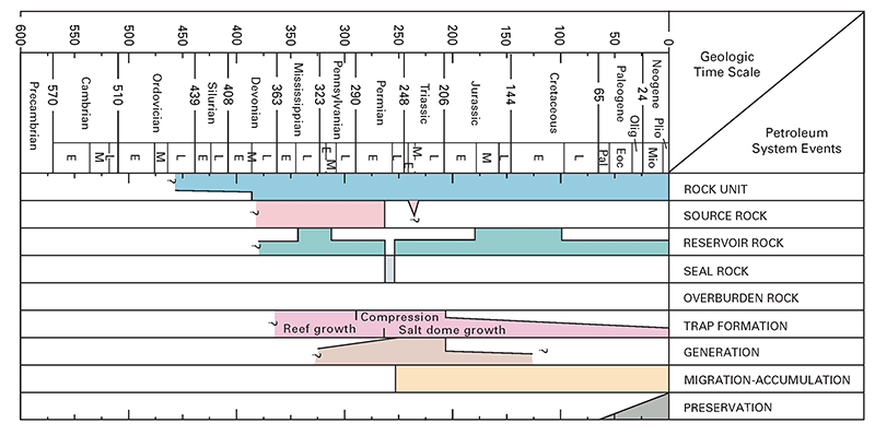
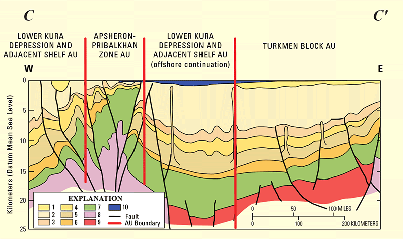 South Caspian Basin Province, 1. Quaternary; 2. M–U. Pliocene; 3. L. Pliocene; 4. Miocene; 5. Oligocene –Miocene; 6. Paleocene–Eocene; 7. Mesozoic; 8. Continental crust; 9. Oceanic crust; 10. Caspian Sea. See map on page 30 for line of section. (Photo credit: USGS, modified from abrams and narimanov (1997)Geoprospecting Together
As already noted, few countries, on obtaining new geological information, share their results with neighbouring institutes, resulting in differences in geological models. Such inconsistency is often caused by ‘overestimation’ of prospectivity of the region, attempting to raise investments. In addition, limited circulation and integration of new geological information means it is difficult to gain a clear understanding of the existing geological model in order to further develop it in an effort to reveal ‘blind spots’ in the understanding of the evolution of geological structures.
So, what geological problems can be solved by all of the countries of the Caspian merging their efforts in order to activate geoprospecting operations in the region? Within the framework of international cooperation, we need answers to the following issues in the fields of tectonics, stratigraphy and petroleum geology, on which the prospectivity of the structural-tectonic complex depends:
– Age and composition of the consolidated crust of the southeastern margin of the Precaspian Depression, Scythian and Turanian Plates;
– Tectonic nature, evolution and structure of the Jurassic-Paleogene of the South Caspian Depression; of the Early Palaeozoic Tugarakchan Trough and the Donbass-Tuarkyr folded system; and of the South Emba Palaeozoic uplift;
– Regional structure of the Upper Permian-Triassic and Pliocene-Quaternary structural stages of the post-salt complex of the Precaspian Depression;
– Structure of Palaeozoic deposits of the ‘folded complex’ sediments of the Scythian and Turanian Plates;
– Boundaries of the Early Permian halogenic basin of the Precaspian, and its interrelationship with the Devonian- Carboniferous and Mesozoic-Cenozoic basins;
– Interrelationships of the folded systems of the Ural and Tien Shan Mountains;
– Post-collision transregional shift faults and their role in the formation of the structure of the ‘pre-platal complex’;
– Unified regional schemes of seismostratigraphic partitioning of the section for each petroleum province and an interregional scheme of the Caspian region as the whole;
– Evaluation of the resource potential of deep horizons, including the formation of hydrocarbon deposits in overpressure conditions and the prediction of high-capacity traps at depths of over 6 km.
– Scientifically grounded estimates of the potential of Palaeozoic deposits of the ‘folded complex’ in the sedimentary and basement rocks of the Scythian and Turanian Plates with non-conventional types of traps, suggesting possible areas for development;
– Scientifically grounded estimates of the potential of the Upper Permian-Triassic complex of the Precaspian Depression and the Upper Jurassic Paleogene complex of the South Caspian Depression;
– Construction of low/medium-frequency oscillation curves of the Caspian’s sea level in the Pliocene-Holocene, caused by geological factors;
– A geomechanical model of spatial distribution of overburden and formation pressures, tectonic stresses, disjunctive faults and dilatancy fracturing of the Earth’s crust in the Caspian region, as caused by local and regional tectonic processes;
– An evaluation of the effectiveness of hydrocarbon exploration in crystalline and igneous basement complexes.
Solving Problems
Regional surveys performed with state-of-the-art technology will enable a detailed scientific interpretation of new information on the geological structures of the Caspian region. This will provide a more reliable estimate of potential resources of the area, uncover the history of geological evolution, making it possible to single out new areas where potential giant and supergiant fields can be found, and will help solve environmental problems associated with oscillations of the Caspian sea level.
.png) Oil derricks on the shore near Baku, Azerbaijan (Credit elnur/Dreamstime.com)Please direct any comments or questions to – Eugenen Petrov petrov@rge-ge
Oil derricks on the shore near Baku, Azerbaijan (Credit elnur/Dreamstime.com)Please direct any comments or questions to – Eugenen Petrov petrov@rge-ge


