
Exploration in the East African Rift System
Billions of barrels of oil have been discovered in the East African Rifts in recent years, but it remains highly underexplored with only two rifts partially explored so far.
The East Africa Rift System (EARS) consists of the Main Ethiopian Rift in the north and a broadly rifted zone in northern Kenya and south Ethiopia which continues southward into a Western and Eastern Rift Branch separated by Lake Victoria (Figure 1).
The western branch of the EARS and the broadly rifted zone of north Kenya and Ethiopia have seen an unprecedented amount of hydrocarbon exploration in the last twelve years since Heritage Oil made the Turaco-1 discovery in the Albertine Graben in 2002 (see Oil and Gas Exploration in East Africa: A Brief History). Over 4 Bb STOIIP have been proven in the Albertine and Lokichar rifts, with more than 20 oil fields discovered in these two basins (Figure 1). The commercial volume threshold has now been reached, but a pipeline to the Indian Ocean and/or an oil refinery are still some years away.

Figure 1: Map showing the East African Rift System. Orange polygons represent Cenozoic Basins and the Red polygon is the region shown in Figure 2. (Source: GEO International)
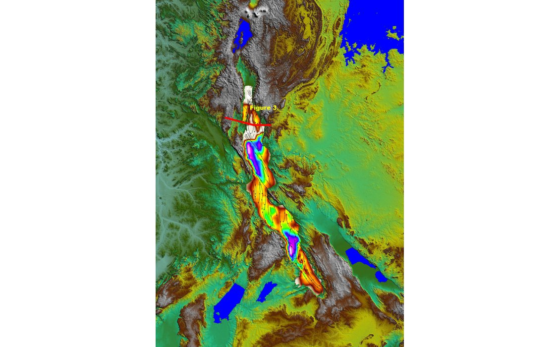
Figure 2: Map of the Tanganyika Rift showing the surrounding topography, the rift fault pattern and the gridded sediment thickness interpreted from project PROBE seismic data (orange shallow to purple deep). Location of cross-section in Figure 3 also shown. (Source: GEO International)
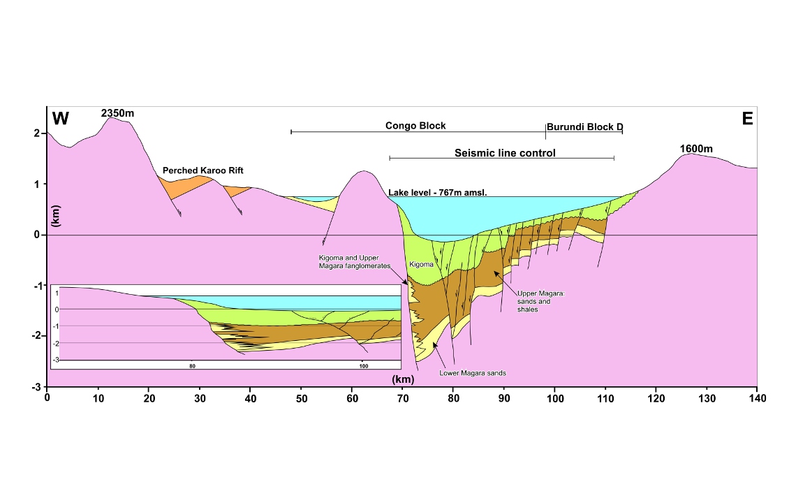
Figure 3: Cross-section through the Lake Tanganyika Rift. Depth conversion of seismic data is based on an average sediment velocity of 2,000ms-1. Inset is at H=V scale illustrating the problem of drilling from onshore into the rift. (Source: GEO International)
Rift Architecture and Fill
The rift system is distinctly segmented, as is each individual rift, where the major bounding faults switch polarity up to five times (Figure 2). The switch in polarity sometimes coincides with the location of Precambrian basement shear zones or earlier Karoo age (Permo-Triassic) rift structures intersecting the EARS.
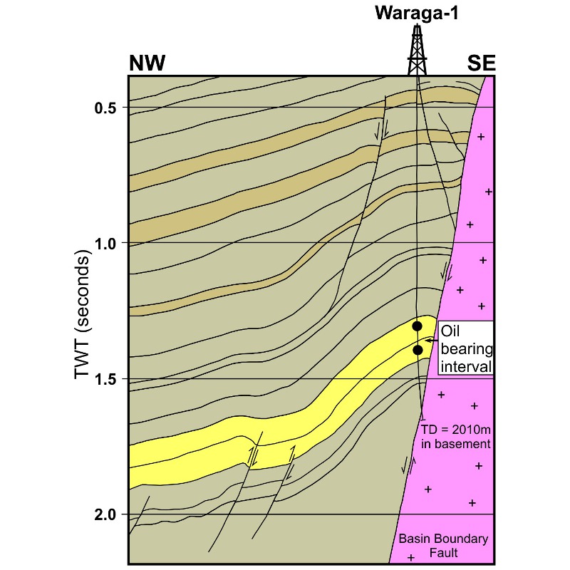 Figure 4: Cross–section through the Albertine Rift Basin showing an example of a successful hanging wall trap, Waraga-1 well. (Source: GEO International)Footwall traps in rotated fault blocks were the principal targets in early exploration, as can be seen in Figure 3. However, hanging wall traps have proved to be one of the most successful targets in the EARS, with discoveries in both the Albertine and Lokichar rifts (e.g. Ngamia, Mputa and Kingfisher). This trap type is usually considered to be high risk because of lateral fault seal concerns, especially in areas that are still seismically active such as the EARS. The critical success factor appears to be a prolific and active source to charge traps, so that even if the fault seal periodically leaks, more oil charge replenishes the structure. In this context it is notable that extensive surface seepage is associated with the Albertine and Lokichar Basins and may be an important exploration indicator for other potentially effective basins. Other successful traps are compressional anticlines that appear to have formed due to slight compressive inversion of the rifts (e.g. Waraga-1 in Figure 4).
Most of the basins in the western branch of the EARS have similar geological histories to the rift segments with proven hydrocarbons. These rifts are filled by fluvial deltaic and lacustrine clastic deposits with limited volcanics. The eastern branch of the EARS was, and is, much hotter than the west with large thicknesses of extrusive lavas infilling the rifts. Sandstone sequences are present in all the rifts, and these can reach a kilometre in thickness near the main sediment entry points (e.g. Buringa-1 and Ruzizi-1 wells in the northern Lake Tanganyika Basin), where there can be hydrocarbon seal problems. In the volcanic areas of the eastern branch and the central broad overlap zone, sandstones often have a large proportion of volcanic detritus which can be detrimental to reservoir quality. However, reservoirs with 15% porosity can still produce at economic flow rates in an onshore situation.
Rift Ages
The earliest volcanics in the EARS are located in the broadly rifted zone where the eastern branch and the main Ethiopian Rift overlap in northern Kenya and Ethiopia. These are dated as Eocene (ca. 45 Ma) and preceded faulting and uplift.
The extensional basins are believed to have been initiated in the Early Oligocene (ca. 30 Ma) based on dating of the Loperot shale located near the base of the Lokichar Basin. The main Ethiopian Rift initiated in Early Miocene times (ca. 20 Ma) shortly after the main outpouring of the Afar Plume volcanics. The initiation of rifting in the western branch of the EARS is poorly defined because the deepest strata in the rifts have not been drilled. However, late inversion of the Albertine Rift has exposed a large upper section of the stratigraphy, where mammalian fossils and geochronological ages of the tuffs can be used to constrain the age of the rift to be older than 14 Ma. The eastern branch propagated southward into the offshore area in the Kerimbas and Lacerda rifts between Mozambique and Madagascar (Figure 5) where the seafloor has been downfaulted, and rifting is probably less than 5 Ma.

Figure 5: Map of the East Africa Rift system in green, showing the main fault patterns and ages of rift initiation. Older basins are shown in orange. (Source: GEO International)
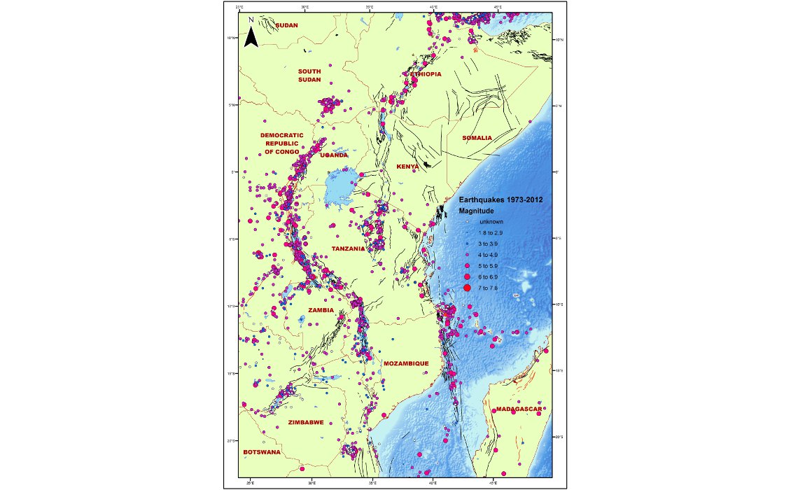
Figure 6: Earth quake occurrences and magnitudes 1973 – 2012 (Source: GEO International/USGS)
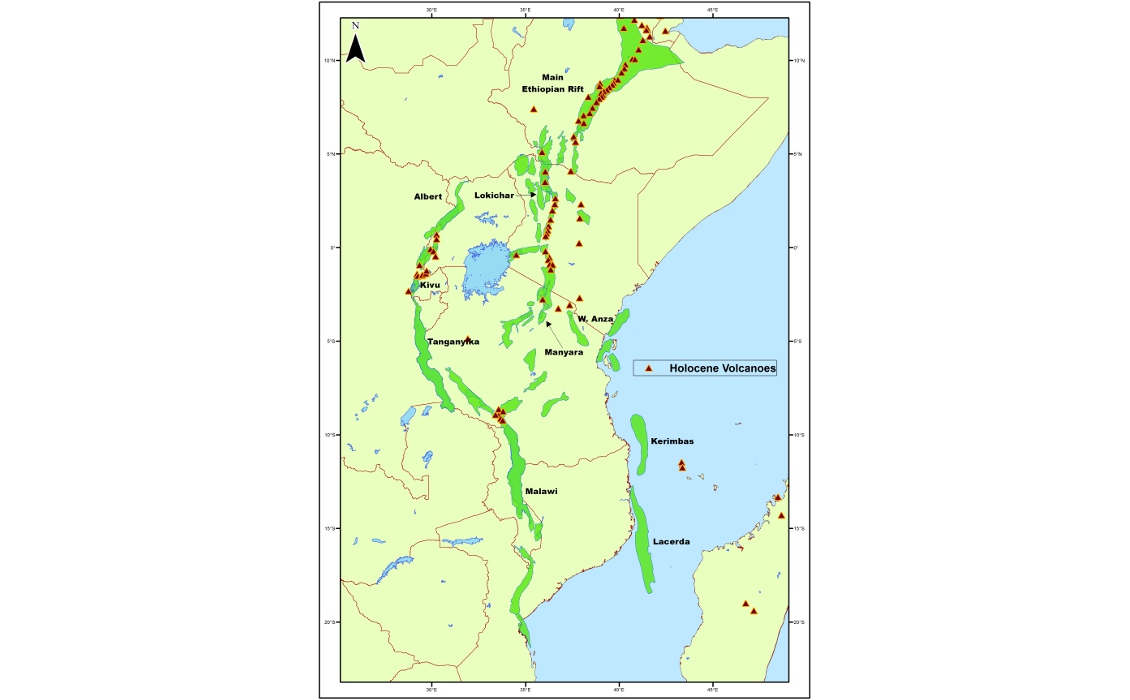
Figure 7: Holocene volcanism along the EARS. (Source Siebert, L. and Simkin, T., 2002)
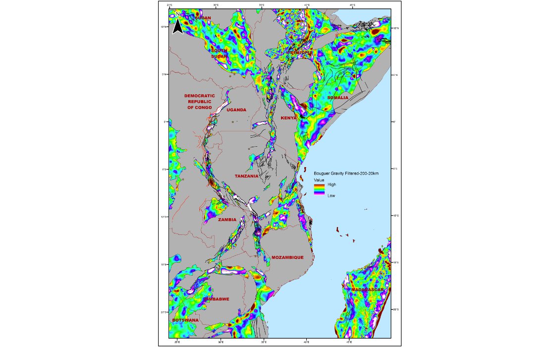
Figure 8: Bouger gravity data, filtered 200-20km. (Source: GEO International/National Space Institute, Technical University of Denmark)
Source Rocks and Maturity
Favourable conditions for source rock development include a rapid rifting phase with a hot humid climate and reduced wind conditions. In such conditions lakes will be deep, fresh to slightly alkaline, and with stable stratification suitable for preservation of organic material. Oligo-Miocene precipitation rates reached up to one metre per year, which favoured deeper lakes. Hot humid conditions will also promote dense vegetation growth and large amounts of organic material will be washed into the basin. The dense vegetation inhibits surface erosion and clastic sediment run-off, which further enhances the source rock potential by diminishing clastic dilution. Intense chemical weathering enhances the nutrient content of the run-off water to promote organic productivity, especially of phytoplankton and cyanobacteria, which are common in present-day African lakes. Some of the lake bottom sediments contain up to 20% TOC in Lake Tanganyika, where water depths were greater than 200m. The lacustrine algal matter generally produces a waxy crude with a fairly high pour point of 40°C, which may require complex production techniques with heated and insulated pipelines.
There is a general problem with predicting source rock maturity where there are variably high heat flows and associated volcanism. Heat flow can be so great that the source rocks can be overcooked within a few hundred metres of burial (e.g. the Main Ethiopian Rift has a geothermal gradient > 200 °C/km in the volcanic segments). Outside the volcanic segments the geothermal gradient is still high and source rocks can be mature at 1–2 km burial. Oil slicks have been recorded in the Abijata, Shala and Awasa lakes of the Ethiopian Rift. However, analysis of slick oil at Cape Kalamba on Lake Tanganyika indicates it was produced by hot springs streaming through shallow organic-rich sediment deposited in the last 25,000 years. Thus, the presence of oil slicks does not guarantee a working hydrocarbon system. All the western branch rifts are predicted to have mature source rocks in the oil generation window.
Future Exploration
The East African Rift System is rightly attracting significant exploration interest because it is a very large accessible onshore basin system, and yet has only recently yielded large hydrocarbon discoveries. It remains highly underexplored with only two rifts partially explored so far, with many undrilled frontier basins highlighted by the Bouguer gravity data still to be investigated (Figure 8). Differentiating effective segments of the rift should benefit from relatively intense fieldwork and geochemical exploration methods, neither of which have been applied in much of the rift system to date. Effective prospect maturation can be achieved with potential field methods such as airborne Full Tensor Gravity Gradiometry (FTG) supplemented with 2D seismic, without the need for expensive 3D seismic (see article on Heritage Oil in Tanzania, V11.5). The combination of appropriate technology and good quality geology has the scope to generate high quality, relatively low cost prospects; and the EARS can deliver play fairways attractive to both smaller and larger companies.
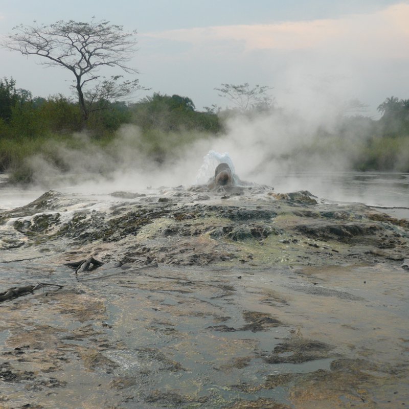 FIgure 9: Sempaya hot springs, south of the Albertine rift. (Source: GEO International)Whilst access is relatively good, with host governments encouraging exploration, there are significant challenges, some specific and some more pervasive. In rift segments with present-day lakes there are some unusual hazards associated with earthquake and volcanic activity (Figures 6 and 7). Around Lake Kivu and in the southern Albertine Rift, for example, CO2 gas accumulation can be a serious problem. A large build-up of this gas within the mud at the bottom of Lake Kivu can periodically vent and spread across the lake as a density current (being heavier than air). With over two million people living in the lake basin, this could cause mass fatalities. Experimental drilling is being considered to vent the CO2 before a catastrophic build-up and release can occur. This may also pose a very serious limitation on being able to drill within the Lake Kivu Rift. The Turaco-3 well in the southern Albertine Graben also encountered anomalously high amounts of CO2 gas and is located near a magmatic segment of the rift, where several hot springs (Figure 9) and volcanic craters are present.
Present–day lakes also inhibit access due to their depth and the lack of ways to bring in floating drilling vessels. Lake Tanganyika, the largest, is 645 km long and up to 1,500m deep, with storm wave heights reaching 6m. Seismic acquired over the lake reveals exciting prospectivity, but clearly drilling will be problematic in the deepest parts of the lake, unless accessible by long reach wells either from shore or possibly from artificial islands in shallow water areas (Figure 3 illustrates the problem).
The western branch of the EARS is considered to be the most attractive; but the main Ethiopian Rift and eastern EARS branch are almost undrilled, and some wells are now required to test whether these hotter rifts have working petroleum systems.
More pervasive access issues relate to production and export options, especially for waxy crudes. Much of the western EARS branch runs at least 700 km inland, and long pipelines to the coast would be required.
Exploration is continuing at a rapid pace, with a high success rate achieved in the Lokichar and Albertine Rifts. The EARS remains highly underexplored, and a combination of geological analysis and modern technology will allow relatively low cost pre-drill analysis. It ought to inspire the smaller, exploration-driven company, for if they can find the oil (and clearly it is there to be found) then history tells us the larger companies will come along to develop it.
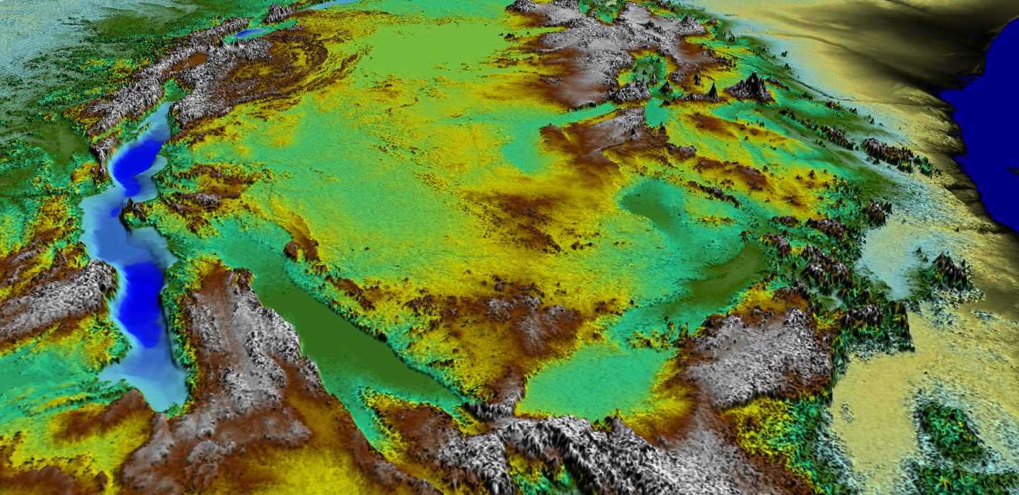 Perspective view of the East Africa Rift System (EARS), looking north, Lake Tanganyika to the left. (Source: GEO International)


