South American Shales: A Regional Assessment
A history of research in tight mudstone rocks, a long record of research in South America and a significant ArcGIS database of wells, seismic and samples across a number of basins on the continent facilitated research into South American shales potential.
Success in the exploitation of gas and liquid hydrocarbons from tight mudstone rocks in North America has spurred interest in and fueled the search for equivalent resources internationally. South America is on the rise as a region that possesses the geological components requisite for shale resource exploration and production. In the past 15 months an assessment of South American basins was undertaken by the Energy and Geoscience Institute (EGI) in a cost-shared partnership with industry associates.
The combined strength of EGI’s history of research in tight mudstone rocks, a long record of research in South America and the availability of a significant database of wells, seismic and samples in a number of basins on the continent were the foundation to assess the merit of each basin. Total Organic Carbon content (TOC), maturity, thickness, lithology and kerogen type were the principle criteria used. Onshore and offshore 136 basins were identified, and approximately 200 distinct shale formations defined. Collection and compilation of available data relevant to shale resource potential in concert with the unique expertise of the South American Shales (SAS) team has created an unparalleled and inclusive evaluation.
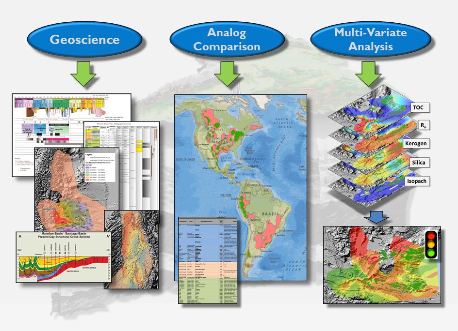
From the initial assessment, eleven basins (spanning five countries) and 27 shales were selected for evaluation in phase one. Geological aspects of shale potential were the primary discriminator, although other parameter data were collected when available. The geological review had a strong focus towards geochemical and petrologic data. To target the areas of interest within a basin the core evaluation elements included an analog comparison of what we found in South America compared to what we knew about North America, a comprehensive geological and geophysical review and a multivariate analysis adaptable to each user’s set of criteria and risk analysis.
Unconventional Approach
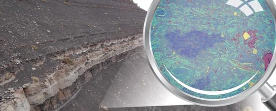
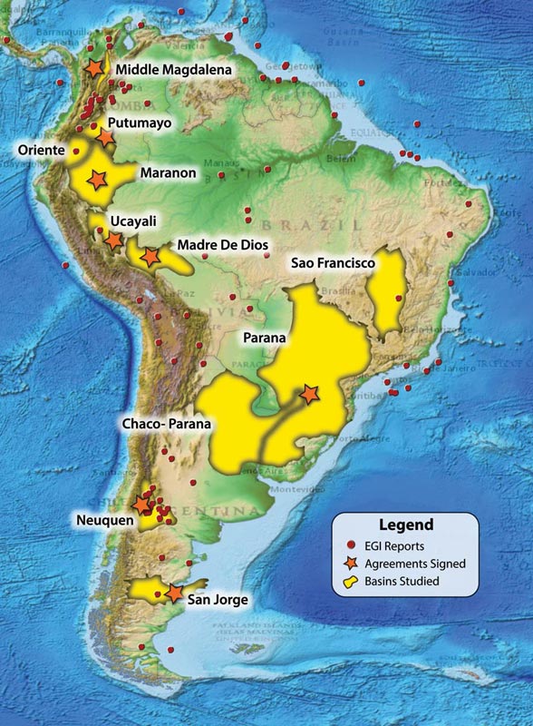 The South American Shale assessment covered 22 shales in 11 sedimentary basins spanning five countries. Also indicated are countries where agreements of cooperation were signed and where EGI has previously completed reports.The SAS Phase 1 workflow combined conventional research methods and data gathering with novel techniques, strategic planning, problem solving, and unconventional approaches to better understand an unconventional resource. To facilitate our analysis the ArcGIS library was built to incorporate the majority of parameters that pertain to shale resource evaluation. Data sources include EGI archives, public domain, country/government oil and gas entities and universities. Sample analysis and quantities were subdivided into core, cuttings and outcrops; geochemical analysis; petrology from thin sections, XRD, QEMSCAN®, SEM/FIB and poroperm; seismic; and well logs.
The E&P industry has shown a significant interest in the ArcGIS library aspect of the project. The task of building this dataset is continuing at EGI and we are in the planning stages of developing this tool as an ongoing, self-contained resource for project sponsors.
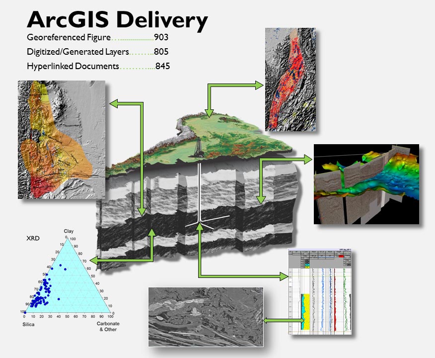
The fundamental delivery of the project was in ArcGIS in which all gathered data were spatially captured.
Geologic Observations
Based on our geoscience evaluations a number of observations can be made regarding the South American shales included in our research. Ages span the entire Phanerozoic time, with some as old as Proterozoic. The global reserve distribution (Ulmishek and Klemme, 1990) shows significant generation/accumulation in the Aptian-Turonian and Upper Jurassic periods and correlates with the occurrence of similar prolific shale/source intervals in South America. An overall correlation between the ages of South American shales and global source rock intervals are recognized and six groupings of shale age are supported by the data. These are Upper Proterozoic, Devonian, Permo-Carboniferous, Triassic-Lower Jurassic, Upper Jurassic-Lower Cretaceous and Aptian-Turonian.
Where samples were available mineralogy was derived from XRD analyses of shales. Comparing the average South American shale compositions to North American shale average values, a wide range of shale mineralogies are represented, mirroring their North American counterparts. Most shales fall within the ‘brittle’ quadrants, although some are transitional to ductile.
Hydrocarbon phase includes both gas and liquid phases in most basins. The Mesozoic foreland basins immediately east of the Andes tend to have immature to oil window maturity profiles, while the basins of the interior craton possessing largely Paleozoic aged rocks range from immature to gas mature. Most of the South American shales contain Type II kerogen, although mixed types involving Type II along with Types I and III are recognized. Representative shales with Type I, II and III are also present.
Analog Comparisons
Both United States and Canadian shales were compared to South American shale information. The range of shale basin sizes is comparable between North and South America.
Average gross thickness of both North and South American shales is within the 30m to 200m average thickness range. Maximum thicknesses for individual shales in South America are in some cases greater than the average thickness of shales in North America.
The depth range of shales in South America is generally greater than 2,000m, with maximums up to about 5,000m. The shallowest North American resource shales can be at depths less than 600m, but also are exploited at depths of 1,500 to 4,500m. Given the diversity of basin types and ages and their related sediments it is not surprising that the depth ranges of North and South American shales are expected to envelope a similar range of depths.
Results of the tight rock analysis commissioned by the SAS Phase One research indicates the porosity measurements are in line with average values from North American shales. It is expected that SAS Phase 2 will commence in late 2013 and at that time the examination of more samples will provide more data for evaluation and comparison.
 Core ArcGIS elements of the project include a geoscience analysis, an analog database and a multivariate analysis.As designed by the SAS Phase 1 project the multivariate analysis can be customized by each sponsor. Considering the diversity of experience, internal database, risking strategies and corporate cultures among EGI’s industry members, an iterative system was delivered to facilitate individualized interpretations. Using the multivariate approach, areas of greater interest in each basin can be identified, while areas of little interest can be eliminated.
The power of integrating analog, conventional and multivariate approaches to our data library offers a novel approach to shale resource evaluation at EGI. The ArcGIS product delivered for this project is designed to allow rapid access to data at both the basin and individual data points scale.
Shale Research – The Future
Mudstone, siltstone, classic shale, black rocks, mudrocks, unconventionals… no matter the description, tight rock reservoirs with low permeability and porosity are targets of the global energy industry and countries seeking resources to enhance national security and future growth. Deciphering these rocks and reservoirs is a primary focus for the EGI scientific staff.
In conjunction with Corporate Associate members, EGI has completed regional research projects to assess and characterize shales in China, South America, and India and has compared and contrasted them with North American analogs. EGI has examined the geomechanical and reservoir engineering aspects of shale gas systems, liquids from shales and shale gas production analysis, and is embarking on low volume hydraulic fracturing for shales, permeability and relative permeability in shales and improved liquid recovery in shales.
Future success in tight rock reservoirs is dependent on a comprehensive understanding of the relationships of shale characteristics, what priorities govern each basin, region, environment, and how the geomechanical parameters increase or decrease long-term and stable production. The combined strength of EGI’s history of research in tight mudstone rocks, a long record of global research and a significant database of wells, seismic and samples worldwide supports a culture that creates applied research and technologies delivered to Corporate Associate members to enhance their ability to produce hydrocarbons from tight reservoirs.
The South American project was sponsored by 25 companies, the largest number of sponsors in EGI’s 41-year history. The full Research Report including the ArcGIS element is available in both hard and digital formats to EGI Corporate Associate Sponsors.


