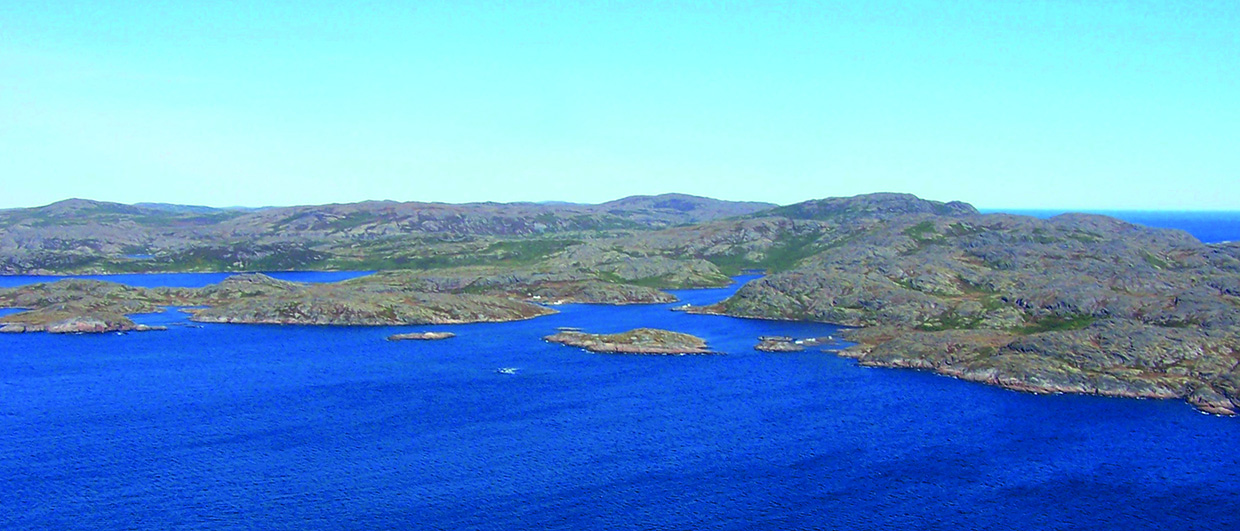
The rugged and pristine coast of Labrador in north-east Canada. Source: Newfoundland and Labrador Department
of Natural Resources – Geological Survey.
Beneath the Labrador Sea
A new seismic dataset helps clarify the deepwater hydrocarbon potential offshore Newfoundland and Labrador in Canada
First oil was produced on the Grand Banks in 1997 from the Hibernia Field and since then the world-class oil-producing fields Terra Nova, White Rose and North Amethyst have come on stream in the Jeanne d ’Arc Basin, and the Hebron field is going into development in the same basin. It is estimated that recoverable reserves of 4.6 Bbo and 18.8 Tcf of natural gas exist in the Mesozoic basins of Grand Banks alone. The 2009 Mizzen oil discovery in the Flemish Pass Basin, estimated at 200 MMbo recoverable reserves, proved the extension of a working petroleum system, sourced by the prolific late Jurassic source rock into an area where it was previously only postulated to exist. The extent of the nascent Labrador Sea in Late Jurassic- Early Cretaceous, north-west towards the Davis Strait, was previously unknown and has now been partially delineated with the new 2D seismic data. This confirms the presence of a continuous Mesozoic rift section throughout the slope and deepwater regions of the Labrador Sea.
Recent work along the western Greenland margin also confirms extensive Mesozoic rift basins, as well as Turonian-aged source rock in outcrop and in offshore exploration wells (Knutsen et al., 2012).
The major period of exploration on the Labrador Shelf was in the 1970s and 1980s, when more than 200,000 km of 2D seismic were recorded and 30 wells were drilled (21 in the Hopedale Basin and 9 in the Saglek Basin) with the last well drilled in 1983. Five discoveries were made in Hopedale Basin of which the Bjarni H-81/North Bjarni F-06 complex is the largest, estimated to contain more than 3 Tcf of natural gas in a Bjarni Formation sandstone of Early Cretaceous age (see dip line, page 29). The three other natural gas discoveries are Snorri J-90 within a Gudrid Member sandstone reservoir (Paleocene age), Hopedale E-33 in a Bjarni Formation sandstone reservoir, and the Gudrid H-55 discovery which has an Ordovician carbonate reservoir. The only discovery in the Saglek Basin is the Hekja O-71 natural gas discovery which is estimated to contain 2.3 Tcf in a Gudrid Member reservoir. It is important to note that all wells were drilled on the shelf and they achieved a 25% success rate.
Significant hydrocarbon source potential
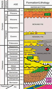
Rifting in Labrador began approximately during the Lower Cretaceous Berriasian and resulted in extensive peneplanation of the basement with earliest syn-rift deposits encountered in shelf wells comprising the Alexis Formation volcanics and the fluvio-lacustrine Bjarni Formation. With expanding section observed on seismic in southern regions, the possibility exists for preservation of older Mesozoic sediment over deepwater regions of the Labrador offshore.
The Avalon unconformity (Cenomanian age) marks the transition into late- to post-rift sediments, which consist principally of marine shales and their more proximal sand equivalent (the Freydis Member). Seafloor spreading commenced in the Late Maastrichtian or Early Paleocene and is marked by the Bylot unconformity (base Tertiary). These syn-rift sediments are mainly marine shales with some submarine fan and shallow marine sandstone deposits (Gudrid and Leif Members). Seafloor spreading ended in Late Eocene- Early Oligocene and is represented by the Baffin Bay unconformity with post-rift sediments comprising terrestrial and marine shales, siltstones, sandstones/ siltstones and glacial beds.
The total organic carbon content of the Lower Cretaceous to Eocene shale deposits is considered sufficiently high to yield significant hydrocarbon source rock potential. Turonian-Cenomanian marine shales of the Markland Formation are immature on the shelf, but are buried at greater depths in the slope and deepwater regions. The younger marine deposits are immature on the shelf, but these shales may reach adequate burial depths in slope and deep water regions, and act as excellent regional seals.
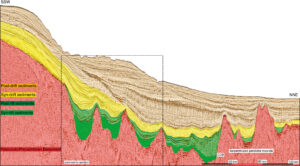
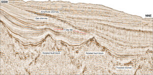
On the shelf the Bjarni Formation sandstone is the most widespread reservoir with both structural traps related to the rift topography and combination structural-stratigraphic traps. The deepwater Bjarni Sandstone onlaps rotated Paleozoic to Precambrian fault blocks and is draped directly over the fault blocks creating 4-way dip traps and the structural highs associated with fault blocks form 4-way dip closures in younger sediments. On the slope and rise the early syn-rift Bjarni is likely similar in depositional character, while the distal equivalents of the Freydis, Gudrid and Leif Member sands are expected to occur as basin fans with trapping mechanisms being stratigraphic and structural, as well as combination traps of both types.
Lower Paleozoic Ordovician rocks include carbonates and dolomites with preserved reservoir quality, as proven by wells in western Newfoundland and by the Hopedale E-33 well and the Gudrid H-55 well in Labrador. Carbonates with reservoir quality were also encountered in a few other wells in the Hopedale Basin, but have not been found in the Saglek Basin where there are fewer wells and those that have been drilled terminated in younger sections. However, Paleozoic sequences are present on Baffin Island and probably offshore West Greenland and may be present in the Saglek Basin.
Evidence of hydrocarbon potential
Discoveries on the shelf have established one working petroleum system, and migration to the reservoir is believed to be short. Basin modeling of the Hekja discovery shows that the reservoir has barely reached the oil-window and the Gudrid sandstone reservoir deposited directly on basalt suggests that the gas in Hekja must have had a lengthy vertical and lateral migration route. This indicates the existence of a source rock located outside the shelf and suggests that there are at least two gas prone source rocks capable of charging large reservoirs.
An oil-seep survey showed several active seeps in an area east of the Hekja discovery, and since gas is the only proven hydrocarbon in this area these slicks indicate another working petroleum system in the region. This is further supported by evidence of a Mid to Late Cretaceous oil prone source rock off of Western Greenland in the Disko Island region (Bojesen-Koefoed et al., 1999, 2004, Knutsen et al., 2012) and the northern tip of the Saglek Basin trend.
A 2010 satellite oil slick mapping survey of the Labrador Sea revealed numerous slicks in the deepwater regions, which were used to optimize positioning of the long-offset GeoStreamer seismic survey lines. Although it is early in the analysis of the new data, there are seismic amplitude anomalies in some of these frontier basins with AVO character consistent with hydrocarbon signatures in analogous basins of similar age. A maturity study conducted in the Hopedale Basin indicate that a depth of 3,300m is sufficient to reach the HC window, while observed sediment thicknesses of 3.5 seconds in the rift-basins close to the COB suggest sufficient burial of the potential Mesozoic (Late Jurassic and Turonian) source material to reach maturity. In some regions, long range migration from these pools to the reservoir may be required, which we know has happened in the Hekja well, decreasing the uncertainty of the play.
De-Risking exploration
Exploration in Labrador has been somewhat dormant for well over two decades, with no deepwater tests ever conducted. The new seismic dataset acquired over slope and deepwater regions will help de-risk future exploration models and provide a much better understanding of the petroleum system. Early indications suggest a Mesozoic rift basin fairway that stretches from the Orphan Basin in the south through to the Saglek Basin in the north, with syn-rift sediments reaching burial depths far in excess of those encountered on the shelf.
Could there have been an early seaway passage between Greenland and Canada providing the correct environment for deposition of high quality marine source rocks in restricted rift basins in Late Jurassic and similarly in the Late Cretaceous? The question is still unanswered, but by covering the failed rift-arm, this dataset provides a unique opportunity to search for these rift basins close to the COB in the hunt for a potential Jurassic and Turonian-Cenomanian source rock. The extension of the Mesozoic rift section throughout the survey area has led to the identification of genuine opportunities on the slope and rise offshore Labrador. Further acquisition will continue to test the potential of the region, with positive insights suggestive that now may be the opportune time to re-engage exploring
Acknowledgement
The authors want to thank PGS, TGS Nopec, and Nalcor Energy for permission to publish this work, and the different contributors from within the PGS organization.
References
Bojesen-Koefoed, J.A., Christiansen, F.G., Nytoft, H.P. and Pedersen, A.K., 1999. Oil seepage onshore West Greenland: evidence of multiple source rocks and mixing. In: Fleet, A.J. and Boldy, S.A.R. (Eds.) Petroleum Geology of Northwest Europe: Proceedings of the 5th Conference. Geological Society, London, 305–314.
Bojesen-Koefoed, J.A., Nytoft, H.P. and Christiansen, F.G., 2004. Age of oils in West Greenland: was there a Mesozoic seaway between Greenland and Canada? Geological Survey of Denmark and Greenland Bulletin, 4, 49–52.
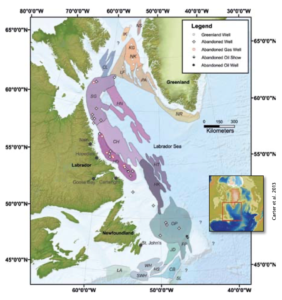
Carter, J.E., Cameron, D.E., Wright, R., and Gillis, E., 2013, New insights on the slope and deep water region of the Labrador Sea, Canada, submitted EAGE London 2013.
Enachescu, M., 2011. Petroleum Exploration Opportunities in Saglek Basin, Area “C”-Labrador offshore Region Call for Bids NL11-03, NL DNR.
Knutsen, S., Arendt, N. P., Runge, M. K., Stilling, J., and Brandt, M.P., 2012. Structural provinces offshore West Greenland and key geological variations influencing play assessments, First Break, 30, 43–55.


