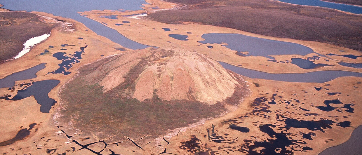
Pingos, unique permafrost have features that look like volcanic cones, dot the otherwise flat tundra landscape on the Tuktyaktuk Peninsula. Pore water is expelled in front of the rising permafrost, and the resulting pressure causes the frozen ground to rise and an ice core to form. Source: Vista GeoScience
Geochemical surface expression of oil and gas in arctic terrains
The Tuktoyaktuk Peninsula is located in the Beaufort-Mackenzie Basin area of Canada and has seen numerous oil and gas discoveries. Using multiple geochemical methods, an orientation survey on the peninsula demonstrated that oil and gas seeps are detectable through thick permafrost, and that these methods can be used as a regional exploration tool.
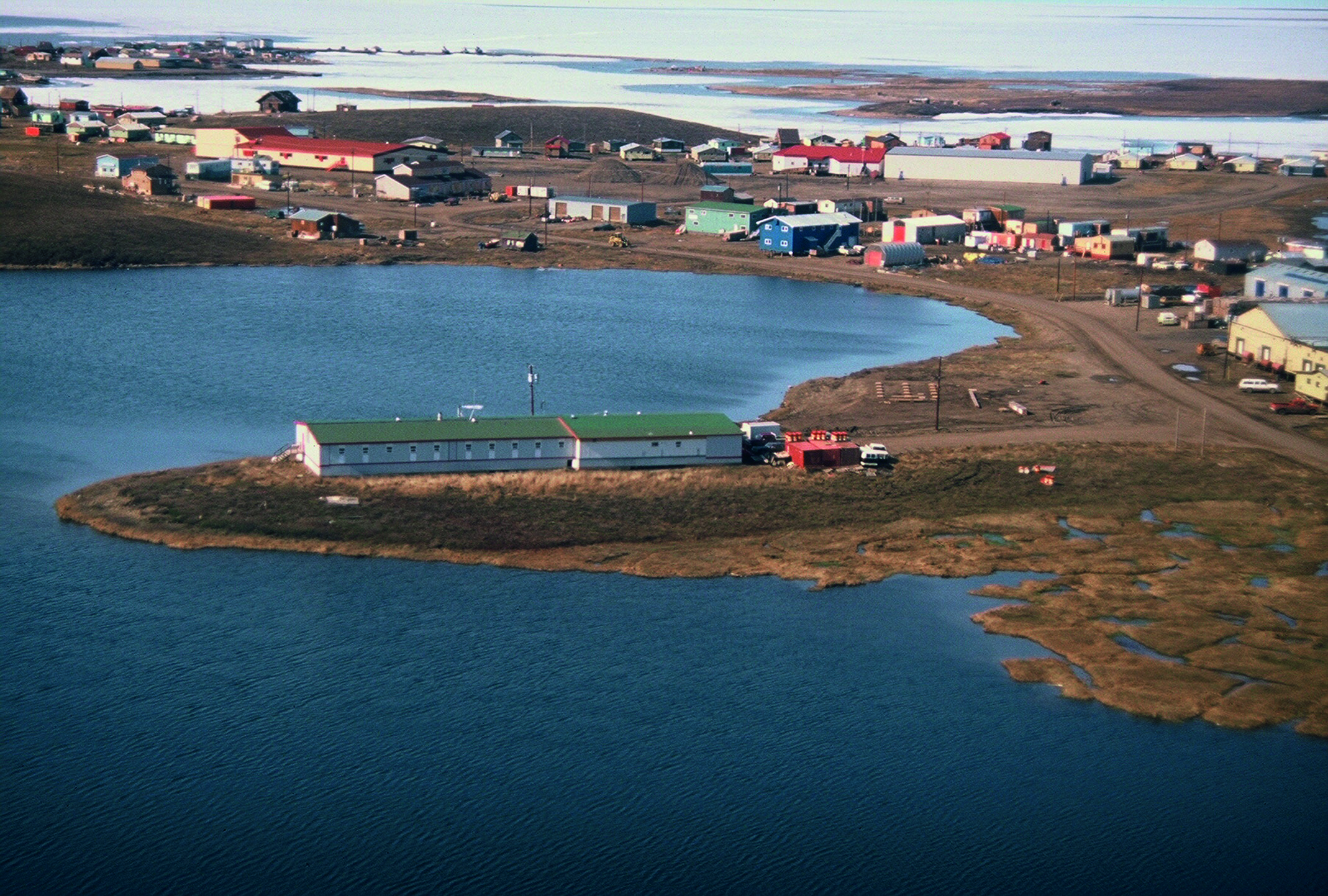
Located in Canada’s farthest northern region, the hamlet of Tuktoyaktuk lies on the Tuktoyaktuk Peninsula at the tip of the Northwest Territories on the coast of the Beaufort Sea. Anglicised from an Inuvialuit word meaning ‘resembling a caribou’, Tuktoyaktuk, or Tuk as it is known, has a local population of around 1,000. There are about 1,350 pingos – unique, conical permafrost heave features – in the Tuktoyaktuk Peninsula area, the greatest concentration in the world. Tuktoyaktuk has more recently become known from the HistoryChannel.com series ‘Ice Road Truckers’, which features the winter ice road connecting Inuvik and Tuktoyaktuk along the Mackenzie River delta.
Arctic environments are challenging areas for oil and gas exploration. Due to remoteness, extreme conditions, limited working seasons and sensitive environments, there are many restrictions and higher costs associated with exploration and development activities. This study area was located just south and east of Tuktoyaktuk. Tuk can only be accessed by the ice road in the winter, by boat or barge in the short summer when the sea ice melts off, and by limited-size aircraft with its one gravel runway and airport. Due to these additional costs and difficult conditions, any tools that are conducive to these sensitive environments can add value and important evaluation information to the exploration programme. Near-surface geochemical exploration methods can be employed at relatively lower costs on a regional scale, have very minimal surface impact in these environments, and fewer permitting requirements, so they fit that category.
There are many unconnected discoveries and reserves in the region. A 1,220 km gas pipeline has long been proposed to link the Beaufort gas fields, via the Mackenzie River valley, to the North American energy grid in Alberta. Companies backing the pipeline – ConocoPhillips, Shell, ExxonMobil and Imperial – are asking the government to help underwrite the projected Canadian $16.2 billion construction cost to help make it feasible. When construction on this project begins, exploration and drilling activity will likely boom again in the region.
Petroleum microseepage
Identification of hydrocarbon micro-seepage anomalies using near-surface direct detection methods over oil and gas deposits in both terrestrial and subsea sediments has seen growing use by explorationists. Visible oil and gas seeps (macroseeps) were historically used to find oil and gas deposits. Searching for microseeps is simply a technological extension of those older methods using sensitive instruments, remote methods and analysis of soil, soil gas or water to detect non-visible trace amounts of oil and gas, or microseeps. Since the near-surface environment determines which types of methods can be used to detect these anomalies, venturing into a new type of environment requires conducting orientation surveys, ideally over known deposits, to determine which method, or combination of methods, will work best in that environment. There was reasonable concern in this study that microseepage could not reach the near surface in areas with thick (100–600m) permafrost, and that this seepage would instead get trapped at the base of the permafrost.
In the arctic tundra environment, collection of free (interstitial) soil gas was not possible due to saturated and frozen soils. Half of the area is covered with small lakes, allowing lake sediments to be used as a matrix to test. The other sampling matrix available was soil from the frozen tundra. In another phase of the study, sediment collected from seismic shot hole borings was also used. Several geochemical analytical methods could be applied to these different matrix types.
Tuk and Mayogiak orientation survey
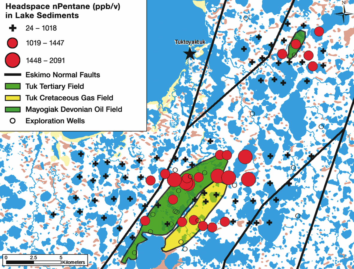
The geochemical orientation survey was designed to look for microseepage anomalies over the Tuk Tertiary oil field (estimated 10–25 MMbo), Tuk Cretaceous gas field (estimated 280 Bcfg) and the Mayogiak Devonian oil field (estimated 4 MMbo) in the Mackenzie Delta of the Northwest Territories, Canada. These fields had been drilled and explored by Esso in the 1970s and 1980s, but were left capped with casing in place with no available pipeline or transportation available for the crude oil or gas. Several years after the orientation survey was completed an additional well, the Tuk M-18, was drilled into the Cretaceous Kamik sands by Devon Energy and Petro-Canada. It has estimated reserves of 200–300 Bcfg and deliverability of 60–80 MMcfgpd. Since the fields were still under virgin pressure, the boundaries were well defined, and the area was clean and void of any producing infrastructure, pits, gas flares, etc., they were ideal candidates for testing the geochemical methodology as a regional exploration tool.
A helicopter was used to access the remote sampling locations in the summer season. For lake sediments, the helicopter was fitted with pontoons so it could land on the lakes allowing the use of a gravity core to collect lake sediments. A total of 85 lake sediment samples and 90 permafrost soil samples were collected at 500 to 1,000m spacing intervals along lines 2,000m apart over an area of 150 km2. Lake sediments were not collected over the Mayogiak field due to time constraints.
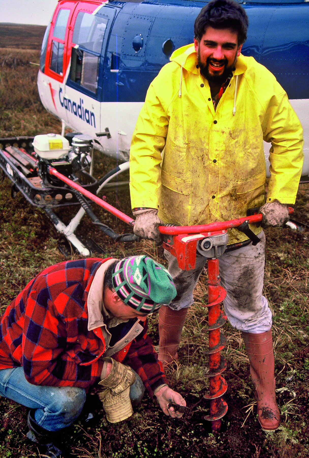
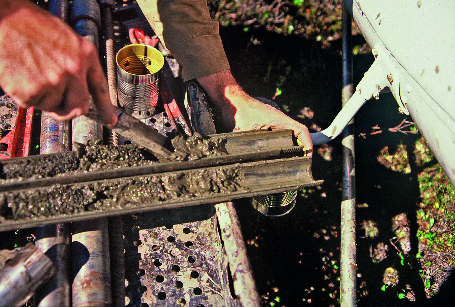
Frozen cores of the tundra soils were collected using a portable 8 horse power auger mounted to the gear racks on the helicopter. After drilling a metre through the upper tundra and frozen sediments, a modified split core barrel with a carbide cutting tipped shoe was used to cut an undisturbed frozen soil core to a depth of 1.5m. Lake sediments were collected using a 30 kg gravity core dropped from the pontoons of the helicopter and penetrated 0.3–1.0m into the lake bottom sediments. To maintain position, the pilot was not allowed to shut down on the lake, so it was rather exciting dropping a gravity core underneath the whipping blades!
A section of the lake sediments and soil cores was placed in a lined metal food-type can immediately upon removal from the core barrel. The remaining volume was filled with hydrocarbon-free prepared water and bactericide to prevent microbial degradation of the hydrocarbons. The can was then sealed on-site with a food canning machine. Back at the base camp, a volume of fluid was displaced with a pure nitrogen headspace injected through a septa built into the lid of each can. The cans were frozen for storage and subsequent shipping.
Direct hydrocarbon detection methods
There is a wide variety of geochemical methods that can be tested in an orientation survey. In this study, four direct hydrocarbon measurement methods were used to analyse the samples and determine which, if any, could detect surface expressions of the oil and gas fields through the thick permafrost. The purpose was to find the most effective method(s) that would then be used to focus or complement higher cost methods such as seismic surveys, and subsequent drilling over onshore parts of the vast and remote Mackenzie Delta and Beaufort Basin areas.
The four methods included acid-extracted C1-C6 hydrocarbons; canned thermally-extracted headspace C1-C6 hydrocarbons; disaggregated sediment headspace C1-C6 hydrocarbons; and solvent-extracted poly-aromatic (C6-C36) hydrocarbons. Analysis of the gaseous hydrocarbons (the first three methods) was done using Flame Ionisation Gas Chromatography. The heavier aromatic hydrocarbons were extracted with organic solvents and the extracts were analysed using a sensitive synchronous scanning fluorescence spectrometer.
To interpret the data, thresholds between background and anomalous hydrocarbon concentrations were determined using probability analysis to see anomalous breaks in the normal distributions. Discriminant analysis, which takes into account the multivariate or compositional nature of the hydrocarbons, was used to see how well each method could distinguish between anomalous and background conditions over and off the oil and gas fields.
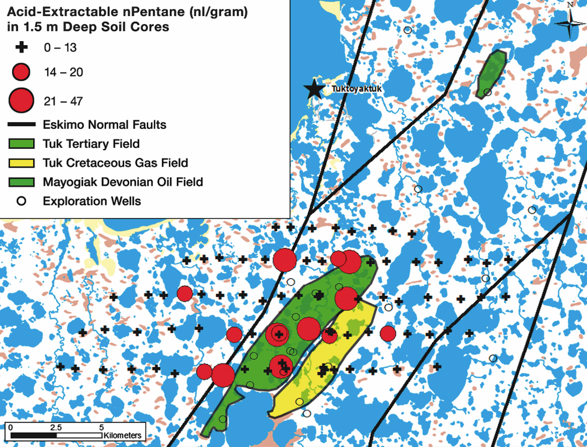
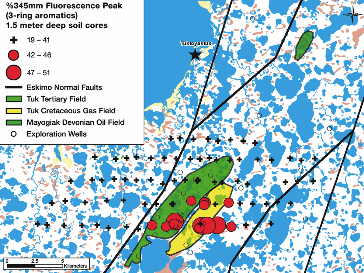
Survey results found that hydrocarbons do migrate vertically through the thick permafrost and are detectable at the surface. Thermogenic (C2-C6) hydrocarbons are anomalous in lake sediments and soil cores over and adjacent to the oil and gas fields. Acid-extractable (C2-C6) hydrocarbons in soil cores and headspace (C2-C6) hydrocarbons in lake sediments provide good anomaly distribution and discrimination between background and productive areas. The blender-extracted gas method showed the least amount of discrimination but still located the productive areas. Fluorescence of aromatic hydrocarbons is anomalous in soil cores over the southern part of the Tuk oil and gas fields, suggesting the ascent of heavier liquid hydrocarbons, possibly along the faults.
The orientation study over the Tuk and Mayogiak fields therefore shows that hydrocarbons present in lake sediments and soil cores provide statistically significant anomalies over the oil and gas fields, and offer useful indications of hydrocarbon accumulations at depth.
The surface expressions seen using these methods demonstrate that they can be used to aide regional exploration in similar environments and geologic settings. The information gained from these types of surveys can help focus where to conduct more expensive methods such as seismic surveys. These methods have also been applied successfully to sediment samples collected from seismic shot hole borings in the same region enhancing the seismic data, and from soil cores and lake sediments collected in similar environments in the Alaskan Yukon Flats area.
About the Authors
DAVID SENESHEN, PH.D., P.GEOL. is Vice President of Exploration Services with Vista GeoScience in Golden, Colorado. David Seneshen completed his Ph.D. in exploration geochemistry at Queen’s University in Kingston, Ontario. He has conducted geochemical exploration surveys for minerals and petroleum both within the United States and internationally for Inco, Western Mining Corporation, the Alberta Geological Survey and most recently with Vista GeoScience, which he has co-owned since 2006. Dave has designed, implemented and interpreted baseline environmental surveys before and after well stimulation in unconventional oil & gas plays as an insurance policy against complaints and litigation from landowners and regulatory agencies. Vista GeoScience is also involved in the characterisation and remediation of petroleum contamination for the oil & gas industry.
JOHN FONTANA, PG, President and CEO of Vista GeoScience in Golden, Colorado, is a professional geologist with over 30 years of experience in environmental investigation and remediation services, and resource exploration geochemistry. John oversees business and technical operations of Vista GeoScience including a geochemical and environmental laboratory, specialised soil gas detection technologies, environmental site investigation and remediation technologies, and has co-authored over 70 presentations and papers on these topics. He pioneered and introduced many of the unique methods and tools Vista uses to support these operations. John developed numerous unique geochemical methodologies for oil and gas exploration. He has provided expert testimony in the area of trace natural gas analysis and natural gas seep related issues. John holds water well contractor’s licences in multiple states and earned a BS in Geology, Oceanography and Physics from Humboldt State University in California.


