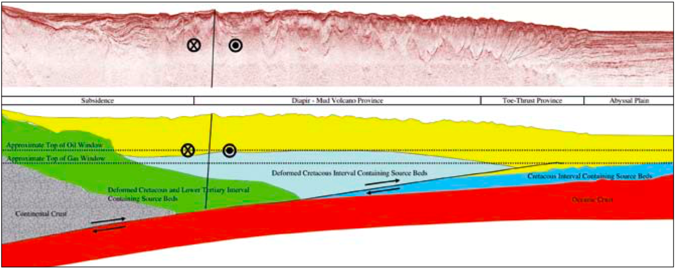
Re-imaged 2D regional seismic will lead to a better understanding of the Trinidad-Tobago and Barbados region and promising new opportunities in the search for hydrocarbons. Improvements in image technology and seismic processing workflow design permit better constraints upon extrapolating shallow water exploration potential seaward towards the ultra-deep. A recently reprocessed vintage data set acquired in the ultra-deep water of Trinidad and Tobago has improved the industry understanding of this hydrocarbon province. Renewed understanding of the geologic opportunities now observed when combined with favorable government fiscal terms should encourage industry interest in this hydrocarbon province. The 2D Deep Atlantic Seismic Programme used in the analysis presented here was originally acquired in 2002. The SR/V New Venture (Veritas) used a 6,000m cable programmed for 240 channels at 25m group intervals with a record length of 9 seconds. The basement of the Trinidad and Venezuela region initially formed during the rifting of North America and Africa in the Triassic. At this time, Cuba was located offshore Trinidad and eastern Venezuela. The northern margin of Trinidad was a strikeslip margin that accommodated the northward movement of North America and Cuba. Onshore, arkosic quartz arenites and conglomeratic limestones were deposited along the coast. Contemporaneously, 60m to 1,500m of shale was deposited offshore. During anoxic conditions thick source rocks formed during the Coniacian-Santonian (Gautier Fm.), Campanian (Naparima Hill Fm.) and Maastrichtian (Guayaguayare Fm.). Occasionally, during lowstands, the deep basin received continental derived arkosic sandstones in the form of turbidite deposits shed off the South American craton in a similar fashion to those recently discovered in French Guyana and West Africa. More than 1,500 km away in the Pacific, a westerly dipping subduction zone was forming on the eastern margin of the Caribbean Plate. The associated calc-alkaline volcanism formed the early stages of the Lesser Antilles (Tobago and Barbados) island arc system. During the Late Paleocene-Eocene-Oligocene-Miocene east-west striking thrust faults developed in the Trinidad region as North America and South America began to converge. To the south of the Lesser Antilles arc system, South America was sliding past at approximately the margin of present day Colombia at a modest rate of 10 mm/yr. Erosion and sedimentation was relatively slow, developing a progradational shoreface with some carbonate bank development. By the late Miocene the region of Trinidad was passing by the southern end of the Lesser Antilles arc system. About 10 million years ago the African plate became fixed with respect to the mantle when it collided with Europe. All of the spreading along the mid-Atlantic ridge had to be accommodated along the Pacific/Nazca/Caribbean and North America/South America plate boundaries. A doubling of the westward velocity (to 20 mm/yr) of South America and North America forced the South American plate to ride on top of the Nazca Plate in the Pacific, causing the Andean mountain range to uplift. The Caribbean Plate has been stationary with respect to the mantle. This plate is subducting into the mantle creating a tensional environment on the west side of the subduction zone. The southern boundary of the Caribbean Plate is in contact with the South American Plate and accommodates this motion by a system of dextral shear faults parallel to the Central Range Fault in Trinidad, and the El Pilar Fault in Venezuela. By four million years ago an increase in siliciclastic sediment influx occurred in the Trinidad region as large volumes of sediment from the newly uplifted highlands in the Andes was transported down the Orinoco and Amazon Rivers. This created rapidly filling basins with overpressured shale, which may have been generated in part as the prolific Albian source rock (Gautier Formation in Trinidad, equivalent to the La Luna in Venezuela and Colombia) passed through the oil window and into the gas window. The overpressured shale became mobile, forming diapirs and mud volcanoes. This recent sediment influx has driven burial and maturation of the source rock in the region, leading to the recent expulsion and trapping of the majority of the 13 Tcfg and 600 MMbo discovered in the basin. The principle plays that can be pursued in this environment include thrusts in Oligocene and older stratigraphy, Miocene and younger stratigraphy in shale diapirs and adjacent basins, and extensional structures in Miocene and older structures in the Columbus Basin. Thrusted Cretaceous to Oligocene stratigraphy below a Miocene and older unconformity can be observed proximal west of the islands of Trinidad, Tobago and on the island of Barbados and in the Tobago Basin. The key challenges in pursuing this play are identifying valid traps defined by reservoir intervals which are deep enough to escape biodegradation but shallow enough to preserve liquids and porosity. BHPBilliton’s Angostura Field is a good example of this play. This field is challenged by shallow depths that have led to biodegrading of the oils. The Woodbourne Field on the island of Barbados was discovered in the late 1950s and has produced 9 MMbo since 1966. The field is shallow and has API gravities that range from 11° to 32°. Structures and stratigraphic traps containing Miocene and younger stratigraphy are present throughout most of the region west of the islands of Trinidad and Tobago and Barbados. The core of the accretionary prism has the highest amount of shortening and deformation due to shale diapirism. The best defined structures and stratigraphic traps are on the margins of the Diapir Province near the islands. The authors would like to thank Spectrum/GeoServe and the Government of Trinidad/Tobago for permission to show the seismic data.
Exploration potential of deep water offshore Trinidad, Tobago and Barbados
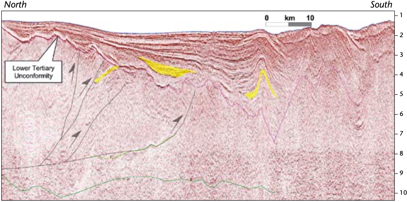
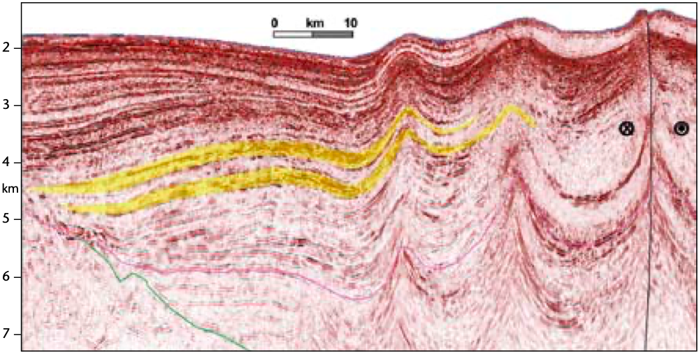
 Seismic line through the Trinidad, Tobago and Barbados Accretionary prism. The basal dark green line marks the basement. The light green marks the top of the Cretaceous. The purple marks the Oligocene unconformity.

The deep unexplored waters off Trinidad, Tobago and Barbados
The deep and ultra-deep waters of offshore Trinidad, Tobago and Barbados have remained underexplored due to structural and stratigraphic complexity. Although nearly every well encountered some measure of hydrocarbons, exploration efforts in the deepwater region have been challenged by sub-economic accumulations, high pressures which restrict the drilling window, thin sands on the top of structures, complex pathways which may restrict charge, thin or unconsolidated seals which may not be effective enough to hold the oil or gas column, and shallow oil which has been biodegraded. Recently re-imaged 2D regional seismic data released by the Ministry of Energy and Energy Industries, Trinidad-Tobago and Barbados region, may lead to a better technical understanding of the region and new promising opportunities in the search for hydrocarbons.
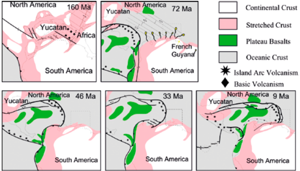
Plate tectonic setting
Exploration potential
Acknowledgements:
Related Articles


