The Zagros fold and thrust belt of Iraqi Kurdistan is a prolific petroleum province with several large-scale producing oil and gas fields. The region is under active exploration and hence production is expected to rise over the next few years.
Reservoirs are primarily fractured carbonates at a variety of stratigraphic levels, with different fracture intensity mainly controlled by mechanical stratigraphy, the structural position of the regional thrust-related anticlines, and present day in-situ stress.
The Zagros fold and thrust belt in Kurdistan can be divided into four distinct structural zones. From the north-east hinterland to the south-west foreland these are known as the Zagros Suture, the Imbricated Zone, the Highly Folded Zone and the Foothill Zone. The Imbricated and Highly Folded zones are characterised by major surface-breaching, mainly south-west-verging thrust-related anticlines, whereas major folds above blind thrusts characterise the Foothill Zone. The trend of fold axes varies from north-west to south-east in the Zagros to west-north-west to east-south-east in the Taurus Mountains. The structural style of the Zagros fold and thrust belt in Iraqi Kurdistan is characterised by both thin- and thick-skinned tectonics.
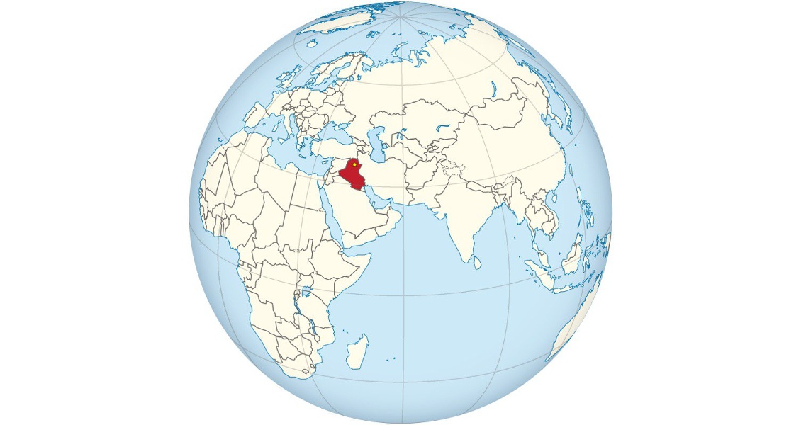
Iraq, with location of Kurdistan capital Erbil shown. (Source: TUBS)
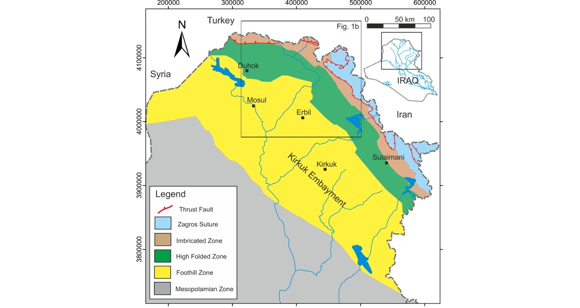
Tectonic map of Iraqi Kurdistan. (Source: A. Awdal)
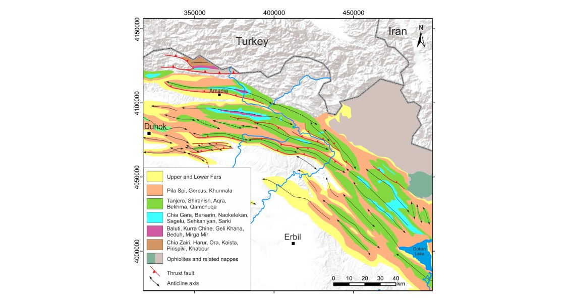
Simplified geological map of northern Kurdistan showing the anticlinal axes and related thrust faults. (Source: A. Awdal)
Fractured Reservoirs
A reservoir fracture is a naturally occurring macroscopic discontinuity in rock due to tectonic deformation or pressure solution mechanisms. Natural fracture systems can have a variety of effects on reservoir performance and well rates, which must often be predicted long before they are evidenced in production data. In folded rocks, the existence of a pre-fold fracture network contributes to a mechanical anisotropy of the strata that apparently controls the subsequent fracture development during folding. In his book Geologic Analysis of Fractured Reservoirs, Ronald Nelson has introduced a classification of reservoirs based on the porosity and permeability of both rock matrix and fractures. Based on this classification, most fractured reservoirs in Iraqi Kurdistan are either Type II, where fractures provide the essential permeability, or Type III, where fractures contribute to the permeability of an already producible reservoir.
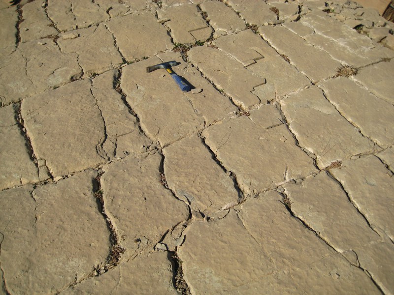 Fracture pattern in the Upper Cretaceous Shiranish Formation, Highly Folded Zone, east of Erbil. (Source: A. Awdal)The fractured reservoir units in Kurdistan are found in rocks spanning in age from the Neogene, such as the Jeribi Formation, to the Triassic, which includes the Kurra Chine. The most common fractured reservoir units in Kurdistan are the Pila Spi Formation (Paleogene), the Cretaceous (Shiranish, Bekhme, Kometan and Qamchuqa), the Jurassic (Najmah and Sehkaniyan/ Mus), and the Kurra Chine (Triassic). Study locations across wide areas of the Kurdistan Region contain excellent surface outcrops of these important fractured reservoir units, exposed in large-scale fractured periclines (four-way closure anticlines). Quantitative characterisation of fracture networks measured in these outcrop analogues, combined with sub-surface data, provides the basis for robust discrete fracture network models, which can be used to predict both flow performance and recovery factor for these reservoirs.
Mechanical Stratigraphy
The term ‘mechanical stratigraphy’ implies that the rock consists of layers that have different mechanical responses to stress, because they have different strengths and different elastic moduli. In simple terms, layers dominated by clay or shale accommodate strain in a ductile manner, while stronger layers such as limestone or cemented sandstone can accommodate higher levels of strain and therefore deform in a more brittle manner. The result is that, in a layered sequence, fractures initiate in certain layers, while adjacent layers are either unaffected or less affected by such brittle structures. Fractures are typically stratabound and span the thickness of the mechanical layer and commonly abut the bounding stratigraphic horizons.
In addition, a proportion of fractures develop into larger scale structures that cross the bed boundaries and may be tens of metres in length and height. These are referred to as ‘fracture corridors’ and, for those with offset, ‘sub-seismic faults’. They are important because they can have significant impact on fracture connectivity and thus on well performance.
Stratabound fractures and fracture corridors in the Sinjar Formation (Lower Eocene) near Sulaymaniyah. (Source: J. Gutmanis)
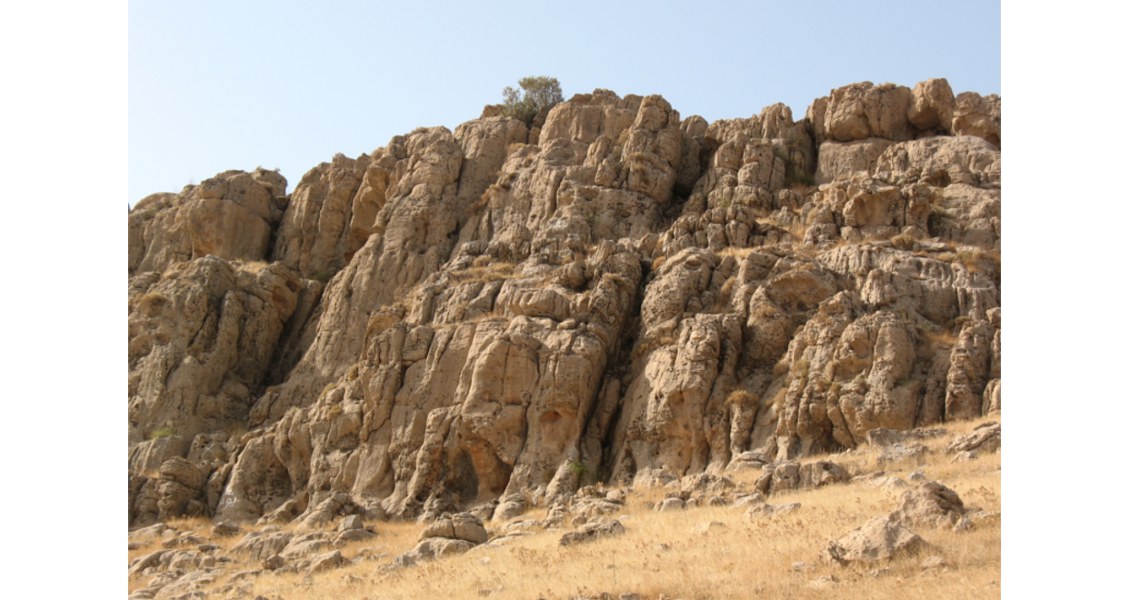
Upper Cretaceous fractured carbonates in the north-east limb of the Ranya Anticline, Highly Folded Zone, east of Erbil. (Source: A. Awdal)
Structural Style
As noted above, the structural style of the Zagros fold and thrust belt is characterised by both thin- and thick-skinned tectonics. In addition, it is segmented due to the interaction of the exposure level and variations in active decollement levels along strike. Complex hybrid compressional structures developed, which are the products of earlier thick-skinned faulting and folding, later modified by younger thin-skinned thrusting and folding. The main thin-skinned detachment levels occur in the Lower Fars (Neogene), the Gercus-Kolosh (Palaeogene), the Jurassic, and the Baluti (Upper Triassic). In addition, thick-skinned detachment levels are likely to occur at one or more deeper levels within the Palaeozoic (e.g. Ora Shale). Dip section variation along strike is observed due to decreases in stratigraphic separation across the faults, and systematic shortening varies with stratigraphic level. Most shortening is observed within the Tertiary, and at top-Cretaceous and top- Jurassic, whereas the least shortening is found in the top-Triassic carbonate units.
Depth to the basal detachment is yet to be accurately defined in Kurdistan. The basal detachment layer is commonly interpreted as being detached on the Cambrian Hormuz Salt in the Iranian Zagros. However, it is assumed that the Cambrian Salt pinches out to the northwest of the Zagros and that the fold and thrust belt in Kurdistan is detached on Ordovician and Silurian shales. In a recent study, the basal detachment is assumed to be in the Ordovician-aged shales or within any other mechanically weak layer overlying the basement. In addition, this study predicted duplexes comprising Triassic and Palaeozoic rocks in the deeper subsurface. However, the prediction of duplexes in Kurdistan needs further investigation. Further complexities can be represented by decoupling structures. In south-eastern Iraqi Kurdistan, for example, the surface structures are decoupled from the more complex subsurface structures by multiple thrust sheets.
The presence of a strike-slip component is observed in outcrops and documented in the subsurface in the Zagros of Kurdistan. In the Taq Taq field, for example, dextral transpression parallel to a north-west–south-east shortening axis is evidenced by oblique slip slickensides on faulted drill cores. In addition, the top reservoir map derived from interpretation of 3D seismic data suggests that a set of parasitic folds trending east-north-east to west-south-west is present across the axis of the anticline. These features are interpreted as oblique minor folds related to a steep dextral fault striking north-west–south-east, parallel to the anticline axis.
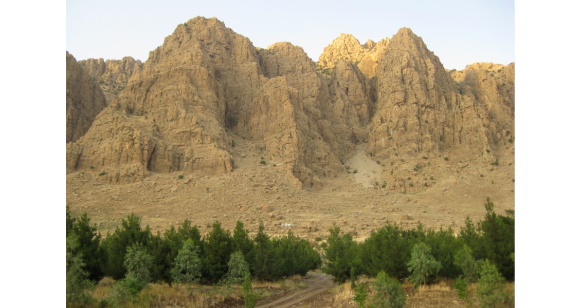
Steeply south-west-dipping limb of a typical anticline in the Highly Folded Zone west of Sulaymaniyah. (Source: J. Gutmanis)
Structural Inheritance
Structural inheritance is only occurring at specific levels of sequences undergoing contraction. Inherited pre-orogenic deformation structures oriented perpendicular to the shortening direction can be reactivated during foreland flexuring.
Some anticlines in Kurdistan formed as a result of reverse movement on pre-existing normal faults during the Late Miocene–Pliocene compression of the Zagros. Others, however, may be formed by inverted half grabens. Inversion has placed Cretaceous basinal facies of generally poor reservoir quality in structurally elevated positions, whereas shelf carbonates with higher reservoir potential tend to be located in synclinal areas representing former footwalls. These anticlines are also characterised by relatively simple structural closure of the shallow stratigraphy, with a structurally more complex underlying section due to restoration of the graben by inversion to its pre-late Cretaceous structural configuration. Furthermore, basement blocks are possibly involved in the thick-skinned tectonic phase and there is most likely reactivation along some of the pre-existing late Cretaceous extensional faults. Reactivation and stress reorientation around basement faults is also suggested along the Iranian Zagros fold and thrust belt. The best producing wells in some fields, such as Gachsaran, are thought to be located close to north-north-east-trending basement faults.
Summary
Hydrocarbon reservoirs in the young and seismically active Zagros fold and thrust belt of Kurdistan sit within generally complex structures that are ‘stress sensitive’. In addition, they often have complex facies distributions and diagenetic histories related to phases of extension prior to the late Cretaceous to Tertiary inversion when structural inheritance and reactivation of fractures become important. Understanding the relative timing of trap formation, porosity development and hydrocarbon charging is essential – ‘it’s all in the timing’. This requires a multi-disciplinary G&G approach to produce robust constraints on reservoir modelling, plus close liaison with reservoir engineers in the simulation process. In this way, uncertainties and risk in developing these challenging reservoirs can be minimised.


