Zeus and Zeebries: Significant exploration insights
High-quality 3D data could provide new exploration opportunities in this highly prospective part of the Northern Carnarvon Basin, where underexplored areas exist within close proximity to producing fields.
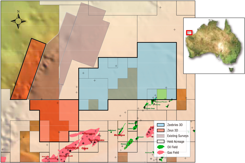
These survey areas are within Australia’s premier hydrocarbon province, adjacent to producing fields and existing infrastructure. The surveys aim to clearly define play levels in the area, including the Triassic Mungaroo fault blocks to the south at the Goodwyn gas field and the Jurassic-Triassic horsts and wrench-controlled troughs to the east. The data is owned by Fugro and marketed by CGG.
To see the full seismic lines please download our PDF for the print issue available through this link: GEO ExPro Vol. 10 No. 2
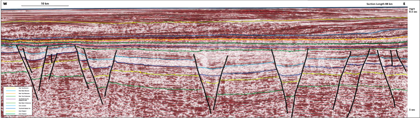
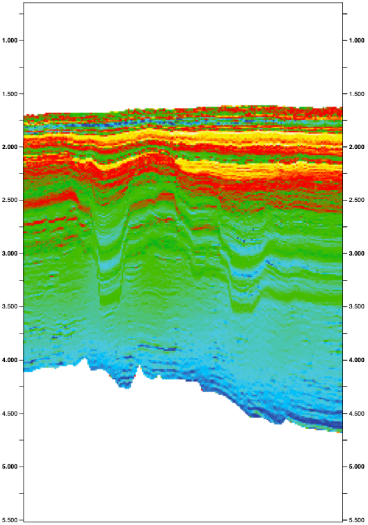
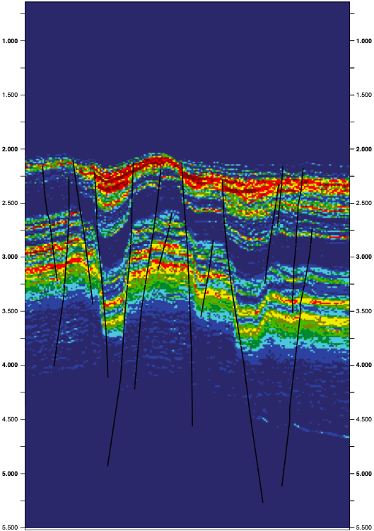
The Zeus and Zeebries 3D surveys are located in the Northern Carnarvon Basin, Australia’s premier petroleum province. The surveys were acquired north-north-east of the Goodwyn, North Rankin and Perseus gas fields, which lie along the Rankin Trend, forming part of the eastern boundary of the basin. The main objective of Zeus and Zeebries is to clearly define play levels within Jurassic Triassic uplifted blocks, horsts, drapes and anticlines, which represent the main structural trapping mechanisms throughout the area.
A full bandwidth simultaneous inversion, including lithology probability volumes, was carried out for the Zeebries 3D by Jason (a CGG company). The inversion volumes were produced to aid interpretation and provide predictive rock and fluid distributions to better constrain subsurface reservoir models. Time and depth migration is being conducted for the Zeus Phase II 3D.
Geological overview
The offshore depocenter of the Northern Carnarvon Basin contains a thick succession of late Paleozoic to Cenozoic sediments. The main reservoir units are dominated by Triassic to Lower Cretaceous fluvio-deltaics and marginal marine clastics, deposited during multiple phases of syn-rift extension. The offshore basin, which covers approximately 535,000 km., evolved from Late Paleozoic pre-rift, to tectonically active Mesozoic syn-rift, followed by subsidence (post-breakup of Gondwana), and finally to a Cenozoic passive margin carbonate shelf (Geoscience Australia, 2012). Sediment thickness in the Northern Carnarvon Basin is known to reach up to 15 km in the Exmouth Plateau (west of the study area).
Regional tectonics produced struc t ural trends oriented north-eastwards, which control the basin architecture and to a large extent the distribution of sediments within the sub-basins of the North Carnavon Basin. Secondary north-oriented structuring is presumed to have developed as a continuation of a Paleozoic onshore trend (Purcell, 1988). The local structural elements throughout Zeus and Zeebries are characterized by a series of complexly-faulted broad anticlines and synclines. Structural traps created by these extensional cycles consist of uplifted blocks, horsts, drapes and anticlines. Mapping of structures throughout the surveyed areas reflects the interplay between underlying basement architecture and syn-rift structuring (Geoscience Australia, 2012).
The interdependent processes that contribute to generation, migration and accumulation of hydrocarbons within the basin are largely controlled by tectonic activity occurring in the Jurassic through to the Early Cretaceous. Petroleum system development can be attributed to syn/post-rift structuring and sedimentation, followed by post-rift reactivation. These cycles produced the necessary elements for the occurrence of hydrocarbon accumulation, within the thick successions of late Paleozoic to Cenozoic sediments.
Hydrocarbon sequences
The main hydrocarbon generative sequences consist of gas-prone source rocks of Triassic Jurassic marine and fluvio-deltaic successions. Geochemical studies undertaken in the area indicate that gas accumulations along the Rankin Trend originate from Triassic source rocks deposited in fluvial to marine environments. The studies further indicate that accumulations in adjacent areas to the east of the project area were sourced from Jurassic fluvio-deltaic and marine successions (Boreham et al., 2001, Edwards and Zumberge, 2005).
Pre-rift to active margin reservoirs within the Northern Carnarvon Basin consist of fluvial and shoreline sandstones of the Triassic Mungaroo Formation and fluvial-marine sediments of the Late Triassic-Early Jurassic Brigadier and North Rankin Formations. These formations are also known gas-prone source rocks. Early syn-rift reservoirs consist of Middle Jurassic deltaic sandstones of the Legendre Formation, which is also a potential hydrocarbon source at distal margins. The main syn-rift reservoirs comprise Late Jurassic to Early Cretaceous reservoir-quality turbidites, submarine fans, shoreline sands and fluvial sandstones at sub-basin margins. The Lower Cretaceous Muderong Shale provides a regional top seal throughout the Northern Carnarvon Basin. Additional intra-formational sealing units occur in the Cretaceous Barrow Group sediments and Forestier Claystones, the Jurassic Athol and Legendre Formations and the Triassic Mungaroo Formation.
Exploration insights
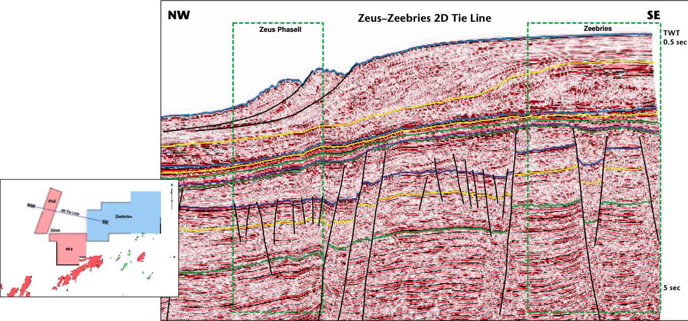
Several wells are located within Zeebries along structural trends to the south-east, adjacent to the Mutineer and Exeter oil fields, and to the north-west along the Brigadier Trend. The wells intersected good-quality reservoir sands at target levels, primarily within the middle to late Jurassic sands of the Angel and Legendre Formations, and the late Triassic to early Jurassic sands of the North Rankin and Brigadier Formations. Preliminary interpretation confirms that similar potential hydrocarbon-bearing closures, at these target levels, can be mapped extensively throughout the survey.
With the added benefit of full bandwidth inversion volumes, the distribution of potential reservoir sands can be mapped more effectively by extending well information throughout the entire volume. The impedance and lithology probability volumes provide valuable information where reservoir sands can be identified with more effective access to hydrocarbon charge than previously known. Discrimination of reservoir sands with intra-formational seals enables the interpreter to more clearly define additional stacked reservoir potential. This is critical where intra-formational claystones are below vertical resolution, or too acoustically subtle to be imaged on reflectivity data alone.
The Zeus surveys provide significant exploration insights to the west of Zeebries, where under-explored areas exist within close proximity to producing fields. Greater understanding of the local distribution and geographic extent of resource plays, made possible by these surveys, could provide the basis for further exploration in this area.
Acknowledgements
The authors would like to thank Fugro for granting approval for publication of the data contained within this article.
References
Boreham, C.J., Hope, J.M. and Hartung- Kagi, B., 2001. Understanding source, distribution and
preservation of Australian natural gas: a geochemical perspective. The APPEA Journal, 41(1), pp. 523-547.
Edwards, D. and Zumberge, J., 2005. The Oils of Western Australia II: Regional Petroleum Geochemistry and Correlation of Crude Oils and Condensates from Western Australia and Papua and New Guinea.
Geoscience Australia and GeoMark Research Ltd., unpublished, in Australia 2012, Offshore Petroleum Exploration Acreage Release.
Purcell, P.G., R.R., 1988, The North West Shelf Australia: Proceedings of Petroleum Exploration Society, Australia Symposium, 1988, 112.


