A museum is a place where objects of artistic, historical, and scientific importance are preserved. We go to museums to learn about and study our past. The British Museum in London and the Smithsonian in Washington, D.C. house many past accomplishments of man and how world events, both natural and manmade, have affected the world around us.
Western Newfoundland offers similar opportunities that attract millions of visitors to these great museums of the world: a unique chance to learn about the past. The global effects of plate tectonics abound here. The associated rifting and mountain building events have formed potential oil and gas basins and displaced rocks from deep within the earth over portions of these basins. All are beautifully displayed along the scenic coast of Western Newfoundland where visitors can explore World Heritage sites, coastal fishing villages, sail along steep-sided fjords, or simply enjoy a quiet walk on the beach.
Plate tectonics
 Western Newfoundland lies along the Appalachian structural front (shown in red on the insert map) with the Anticosti Basin lying to the north-west as do most other Paleozoic Appalachian basins. The Seamus #1 well and key onshore locations are near the Western Newfoundland coast and along the eastern portion of the basin. Image: Newfoundland Dept. of Natural ResourcesLike most good museums, you must start on the ground floor; in this case Gros Morne National Park. Designated a World Heritage Site in 1987 because (from the park’s brochure), “The rocks of Gros Morne National Park and the adjacent part of Western Newfoundland provide some of the world’s best illustrations of plate tectonics, one of the most important ideas in modern science.”
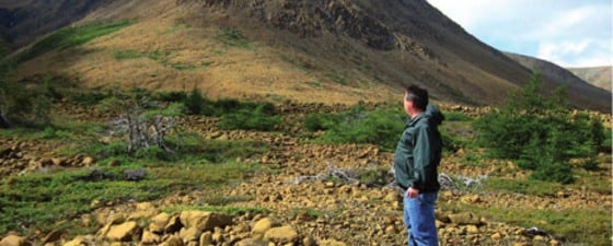
An ancient continent can be seen along the cliffs of Western Brook Pond, where glaciers have exposed granites and gneisses 1.2 billion years old. Volcanic rocks exposed along the present-day shoreline give witness to a time when this super-continent Rhodinia split apart and a new ocean started to form. The limestone and quartzite exposed along the cliffs and mountain tops in the upper parts of Bonne Bay were deposited near the shoreline of this ocean. Finally, sediments that were deposited along the base of the continental shelf can be found along the northern shoreline of the park.
Deposition along this margin lasted into the early Ordovician, when forces inside the Earth changed. The ocean started to close and the tectonic events that followed created the park’s most obvious geologic feature, the Tablelands, which can be viewed from near the visitor’s center across Bonne Bay. These are some of the best exposures of mantle rocks anywhere, and also may be some of the most accessible. The rocks comprising the Tablelands were emplaced as a result of this ocean being subducted under the continental land mass and the eventual collision with Gondwana in the late Devonian. Large slices of rock, including those from the Tablelands, were scraped up and over the strata that bordered the continent of Laurentia.
Petroleum geology
 The Gros Morne National Park visitor’s center gives a good overview of the park’s exceptional geologic and biologic features. Photo: Tom SmithThe next ‘floor’ in this outdoor museum, actually along the coast just north of Gros Morne National Park, is devoted to petroleum geology and how it may relate to plate movements. Much of what is exposed at the surface are the allochthonous rocks that were shoved out of and over parts of the early Paleozoic Anticosti Basin. These rocks give the geologist a peek at what may be encountered below this allochthonous package into the less disturbed underlying rocks.
Knowing the location of the ancient plate boundaries and continental margins yields additional insight into the petroleum potential in the Anticosti Basin. From large gas discoveries off the coast of Labrador to the prolific Arbuckle and Ellenburger formations of Oklahoma and Texas and points in between, the ancient Laurentian margin is no newcomer to large oil and gas discoveries. All of the Cambro-Ordovician basins along the Appalachian and Ouachita mountains have production. Deep exploration is just beginning in the Anticosti Basin, one of the last largely unexplored basins along this margin.
Exploration History
No museum is complete without some relics from the past and the Parson’s Pond area (about 50 km north of Gros Morne National Park) is our next stop. Mr. Parsons skimmed oil from the lake that bears his name nearly two centuries ago to be used as a cure for rheumatism. Others seeking oil followed. In 1867, John Silver, using a steam powered drill, found “some oil and gas shows” in his 213m deep well. The 1890’s saw more attempts to find oil in the shallow strata around the lake when the Newfoundland Oil Company drilled a well down to 396m. Again, oil and gas shows were encountered and the company deepened the well, torpedoed (dynamited), and “pumped six barrels in a very short time”. The first 15 years produced less than 2,000 barrels. The company sold 900 barrels to St. John’s Gas and Light Company for $1,460 and subsequently went out of business in 1907.
For the next 100 years, various companies drilled more wells into the underlying shales near Parson’s Pond, encountering small amounts of oil and gas. At present, however, the first wells are being drilled through the allochthonous section and into the underlying Ordovician carbonate reservoirs. The Seamus #1 has been completed to a total depth of 3,160m and has encountered a hydrocarbon bearing zone that is to be evaluated later this summer. The drilling rig will soon start a second well in a planned three well program headed by Nalcor Energy Oil and Gas (a Crown-owned corporation) and their partners.
Who knows? The current drilling program could complete the link between the productive platform dolomites in Texas and Oklahoma to those of northeastern Canada, a link that started 600 million years ago.
 Amphibious craft that was used to ferry drilling equipment from the coast to drill sites at Parson’s Pond during some of the early exploration phases. Photo: Tom Smith
 The Arches are the remains of a previous glacial cave system. Intercrystalline and vuggy porosity are well developed in these dolomites and fresh surfaces yield a strong petroleum odor. Photo: Tom Smith
Acknowledgements
Special thanks to Larry Hicks and Karen Waterman for the information and great field trip and to Sharon McLennon and the Greater Corner Brook Board of Trade for making it all possible.


