A New Oil Province Offshore the North West Shelf
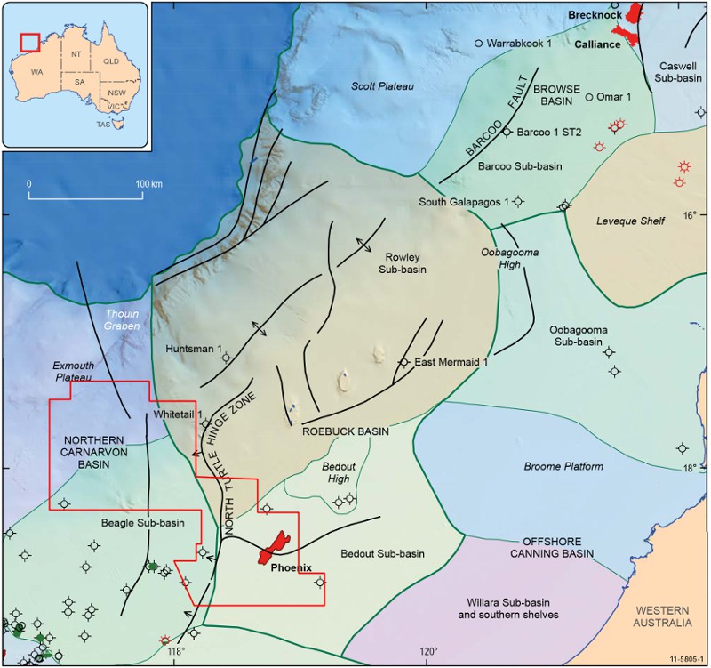
The Australian North West Shelf is comprised of four areas, namely the Carnarvon, Roebuck/Offshore Canning, Browse and Bonaparte Basins. These are filled with a thick sequence of late Palaeozoic, Mesozoic and Cenozoic successions. The area formed part of the Gondwana Supercontinent during the Palaeozoic, but by the Permian rift development had initiated in response to regional extension. Continental break-up began in the early Jurassic, resulting in deposition of syn and post-rift Jurassic to Cenozoic successions.
Northern Carnarvon Basin
The northernmost part of this basin consists of the Beagle Sub-basin and the Exmouth Plateau. Depositional environments consisted of siliciclastic deltaic to marine sequences throughout the Triassic to the Cretaceous. Early to Middle Jurassic rifting occurred followed by deposition of Late Cretaceous to Cenozoic carbonates during post-rift thermal sag.
The main exploration targets in the basin are Upper Triassic, Jurassic and Lower Cretaceous sandstones, with both structural and stratigraphic plays identified, including up-dip pinch-outs beneath the regional Early Cretaceous seal. Jurassic organic rich claystones and the Triassic Locker Shale provide effective source rocks. The area has been extensively faulted by a series of approximately north-north-west to south-southeast and north-north-east to south-south-west high angle extensional faults that can be seen to heavily compartmentalise the potential reservoir intervals.

Roebuck basin
The Roebuck Basin consists of the Rowley and Bedout Sub-basins. The Mesozoic geology of the Roebuck Basin is similar to that of the adjoining Northern Carnarvon Basin, from which it is separated in part by the North Turtle Hinge Zone. The Roebuck Basin is one of the least explored regions of the North West Shelf. It was initiated by extension in the Late Carboniferous to Early Permian followed by regional uplift and faulting in the late Permian associated with volcanism. Subsequent thermal sag in the Triassic led to the deposition of a thick sequence of transgressive marine and deltaic deposits, followed by a series of transpressional events terminating in Early Jurassic extension. Lower and Middle Jurassic sediments were deposited in fluvial and deltaic environments followed by Upper Jurassic regional uplift and erosion. Upper Jurassic to Cretaceous sediments were then deposited, overlain by a thick section of prograding Cenozoic carbonates.
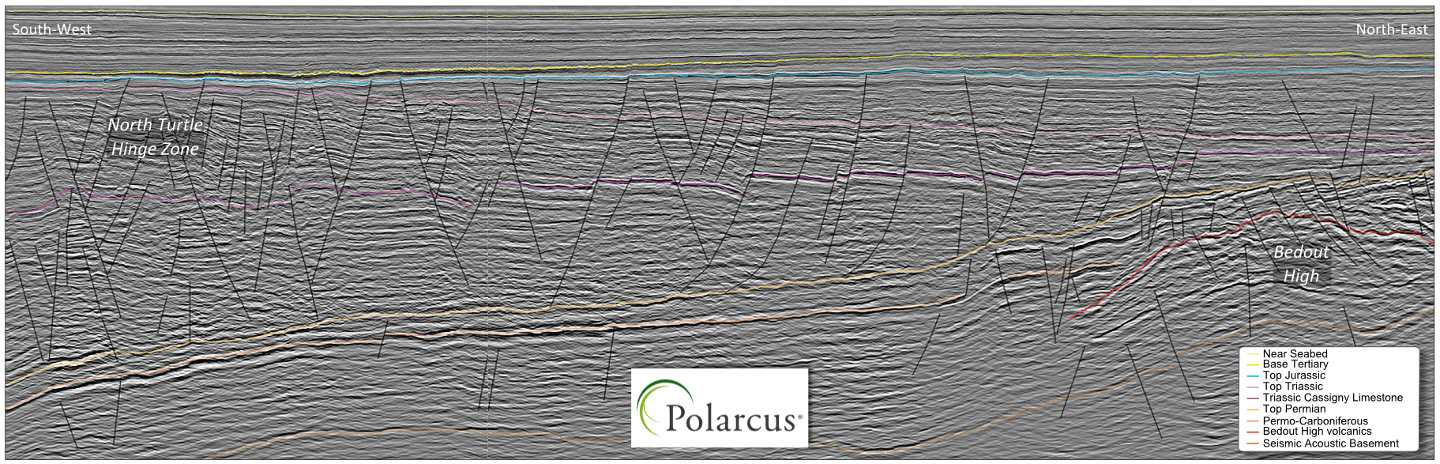
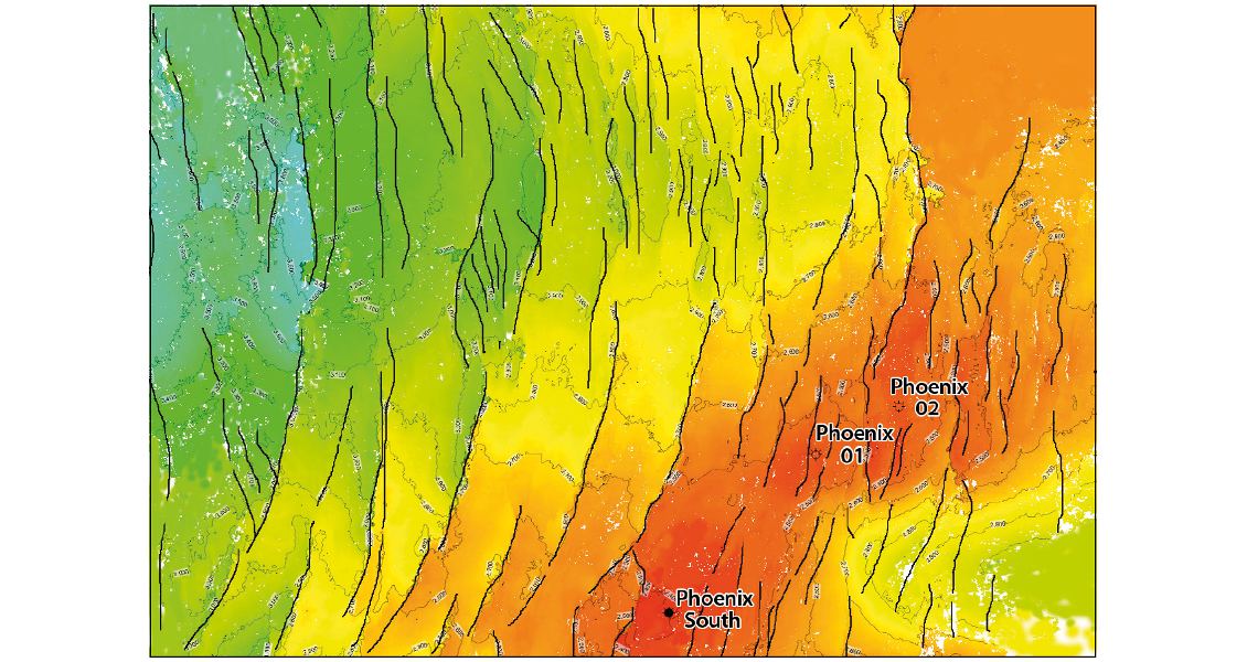
In the Bedout Sub-basin the Jurassic-Triassic sequence can be seen to be strongly affected by a number of extensional faults. In the area south and west of the Bedout High the normal faulting displays a high angle with little rotation of the affected stratigraphy. This can be seen in the area of the Phoenix discoveries where the wells tested the broad structural closure as defined by mapping of the overlying Cassigny Limestone. Toward the west, away from the high, the faults develop a listric character due to decollement within the Lower Triassic shales. This has led to rotation of the stratigraphy within the individual fault blocks, developing a number of potential structural traps to the west of the Phoenix discovery wells.
The volcanic build-up seen on the data at the margin of the Bedout High (see main seismic panel above) has influenced sedimentation of the overlying Triassic sediments, in places leading to complex on-lapping geometries. Beneath the Triassic, the new data also illustrates the complexity of depositional architecture in the Permian across the volcanic high. Reefal carbonates with build-ups atop the high can be seen to grade laterally into fore-reef-slope deposits, in some cases displaying down-lap as the bed-forms prograded basinward.
The main exploration targets in the basin are Lower to Middle Jurassic fluvio-deltaic sandstones; however the basin lacks the Upper Jurassic marine source rocks that are found in the Northern Carnarvon Basin and the presence of adequate source rocks has, to date, been considered a major risk. The Phoenix South oil discovery, sourced from Lower Triassic shales, therefore represents a milestone in the exploration of the basin.
Phoenix South discovery
The Phoenix structure was originally drilled in 1980 by the Phoenix 1 well, followed in 1982 by Phoenix 2, both operated by BP Australia. Both wells encountered extensive gas columns within low porosity Triassic reservoirs. The Phoenix South well was drilled in 2014 by Apache Corporation with Partners Carnarvon Petroleum, Finder Exploration and JX Nippon. The target was the Triassic Lower Keraudren Formation, which pre-drill was expected to contain an estimated 5.5 Tcf of gas with associated volumes of liquids. The well was, however, plugged and abandoned as an oil well, with at least four discrete oil columns ranging in thickness between 26 to 46m being recognised. Evaluation of the discovery is under way, but the oil and reservoir quality encountered point to a commercial discovery. The area also includes a number of large and shallower, untested structures which include the nearby Roc-1 Prospect, scheduled to be drilled later in 2015.
Capreolus 3D Multi-Client Survey
Polarcus is acquiring this RightFlow™ multi-client survey using the Polarcus Asima, Amani and Naila, towing a 12 x 100m x 8,100–9,000m, ultra-quiet Sentinel® solid streamer spread and a 12.5m flip/flop shot interval, delivering 180 fold data and processed with a 12-second record length. Fast Track PSTM data are available now (see main seismic line above) with a PSDM data volume available early 2016. Deeper stratigraphic surfaces can be seen on the fast-track PSTM data volume, and a number of lines across the survey are being processed to 20 sec TWT to allow investigation of the basin-wide tectonic evolution of the area.
New Hydrocarbon Province
The Phoenix South oil discovery has illustrated the potential for a major new hydrocarbon province, which can now be fully evaluated using the newly available data. The Capreolus survey allows a comprehensive understanding of the Triassic and Jurassic reservoirs in both structural and stratigraphic traps across a number of basins, allowing investigation of the spatial relationships of individual mapped stratigraphic horizons and the understanding of the timing of observed events. The data provide a new understanding of the paleogeography, sedimentology and charge history within the individual seismically defined packages.


