The first well of the campaign (15/12-25 – Jerv) was not the success the company and partners OKEA (30%) and Petoro (20%) had hoped for, as it proved the targeted Paleocene reservoir to be connected to the Fleming field on the other side of the median line. So, despite the fact that hydrocarbons were proven, low reservoir pressures prohibit stand-alone development of the accumulation.
More information about the Jerv well:
Chrysaor targets Maureen sands in what may become a cross-border find
A nearby well
This time, Upper Jurassic sandstones of the Ula Formation are the main target.
Looking at the map below, it is evident that well 15/12-26 is being drilled very close to an early North Sea exploration well, 15/12-2, drilled in 1976 to test a so-called Dogger or Middle Jurassic Hugin Formation prospect. The well did prove good quality sandstones, but rather than its predecessor 15/12-1, which had oil shows in time-equivalent sands, the reservoir in 15/12-2 was entirely water wet.
The first question that should now be asked is; is well 15/12-26 really targeting another (younger) sandstone compared to the Middle Jurassic sands drilled by 15/12-2 only 400 m away?
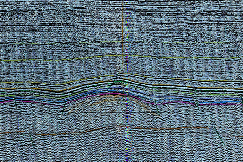
Looking at a seismic section published in the Geological prognosis and drilling program for 15/12-2 (see headline image), it is apparent that the area around both wells is part of a gentle Zechstein salt dome, similar to what was found at the Maureen field about 13 km to the west in UK waters.

The same document also shows a contour depth map of the Late Kimmerian unconformity (see above), with well 15/12-2 indicated by a red dot.
Projecting well 15/12-26 onto this map, it looks likely that the Ilder well is targeting the very crest of the domal structure at BCU level that was mapped at the time – well 15/12-2 was drilled to the northeast of the crest.
Although this in itself is no proof for 15/12-26 to target the same “Hugin” reservoir as the one drilled by 15/12-2, it seems to be a straightforward conclusion that it is. Also, the OKEA 2019 Statement of Reserves and Resources state that the Ilder prospect consists of Hugin Fm sandstones.
How big does it need to be?
This begs another question; why was 15/12-2 drilled off structure? One explanation is that the operator had planned the well in a position where – in case it would prove hydrocarbons – the size of the then discovered closure would have been big enough to justify development, or at least an appraisal well.
With 15/12-26 now targeting the very crest of the structure, and with well 15/12-2 acting as a hard constraint with regards to the depth of the oil water contact, it is likely that the anticipated volume for the Ilder prospect is less than it was for well 15/12-2 (OKEA estimated unrisked resources of the Ilder prospect to be between 6 and 17 MMboe).
If all this speculation proves valid, it is a nice illustration of how economic cut-offs have changed over time and how this is directly influencing the positioning of exploration wells.
Migris, the company that specialises in modelling hydrocarbon generation and migration, reckons that the probablity of oil migration to have taken place in the area of the mapped prospect is 99%, which classifies the well as a class A hole.
HENK KOMBRINK
The seismic line shown above is from the Geological prognosis and drilling program document for well 15/12-2 (the projected well location is indicated by the orange vertical line in the middle). It is clear from this cross-section that the well was drilled slightly off-structure, with 15/12-26 now targeting the crest.


