Back in 1965, Phillips Petroleum was awarded licence P079 in Quadrant 30 during the second UKCS Licensing Round. Eyes were mostly on Mesozoic structures along the Josephine Ridge, but the Paleocene also turned out to be prospective when drilling well 30/13-2 in 1972. That was the start of Talbot’s journey, which may result in a decision to finally develop it almost 50 years later.
Following drilling of 30/13-2, a number of appraisal wells on Talbot also found oil in the same Paleocene Mey Sandstone (30/13a-9 and 30/13a-11&Z). However, the 13.3 MMboe discovery has not been further developed thus far. One of the reasons for this may be the hard to explain geological and geophysical observations made on this what appeared to be an uncomplicated 4-way dip closure.
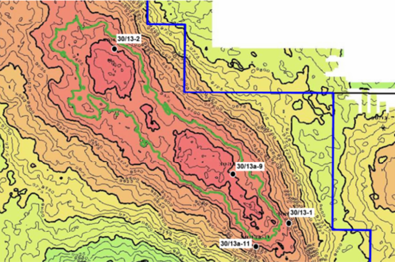
An interesting appraisal history
As is nicely explained in the relinquishment report for Licence P079, the first surprise when drilling appraisal well 30/13a-9 was the observation of an oil-water contact at a slightly shallower level than the oil-down-to (ODT) observed in well 30/13-2. Yet, a paleo-water contact was found to be at nearly the same depth as the ODT in the 30/13-2 well, suggesting that the accumulation could once have been one pool, but subsequent compartmentalisation allowed two different contacts to form.
An even more intriguing observation was made when drilling the appraisal well 30/13a-11 to test the spill point on the southwest flank of the discovery. Due to an error in the depth conversion process, the well was placed slightly differently than anticipated, which led to the top reservoir was penetrated 100 ft deeper. Yet, the well still found the reservoir oil bearing.
Based on these results, side track 30/13a-11Z was drilled to test the reservoir even more downdip and indeed found the Mey Sandstone still oil bearing at a depth of 9759 ft in an ODT setting.
The interesting aspect is that all wells drilled on Talbot so far prove that the mapped Lambda-Rho seismic anomaly lines up with the oil found (see map below). In the north of the discovery, there is good correspondence between the structural closure and the seismic anomaly, but in the south the anomaly is also present outside the initially mapped closure to the west and south, where oil was found.

From one to three compartments
Based on these findings, Talbot was then remapped as consisting of three different compartments characterised by at least three different columns, with all three wells currently drilled on the discovery being in a separate compartment. As seismic data do not show a clear indication what may be the driver behind the compartmentalisation observed, it becomes a little more obvious to see why this discovery has so far been left untouched.
Looking at the location of the currently drilling well, it seems as if Harbour is testing the spill point on the western flank of the closure, where a seismic anomaly can still be seen. According to the OGA, a side-track was spudded on the 1st of September, which suggests that the pilot hole did find oil and that another is now being drilled to further test the reservoir.
Hopefully Harbour will now be able to find enough geological evidence to support further development.
HENK KOMBRINK


