The geological history of the Davie Ridge tells us how tectonic, erosional and climatic forces shaped this part of the earth, pushing the mountains of west Madagascar, which once abutted what is now the coast of Somalia, southwards into the Indian Ocean.
The southwards drift of Madagascar lasted for 50 million years, from the Middle Jurassic to the Early Cretaceous, and was governed by an almost 1,000 km-long north–south fracture zone which, east of the present Davie Ridge crests, is associated with a number of deep north-west to south-east trending faults.
This oblique rather than simple tectonic regime rippled and sheared the continental crust west of Madagascar, eroded and erased mountains, emerged and submerged volcanic islands and created sedimentary basins which were only fully connected when the sea finally inundated all the area between Madagascar and Mozambique in the Miocene.
Mapping Mounds and Evolutionary Bridges
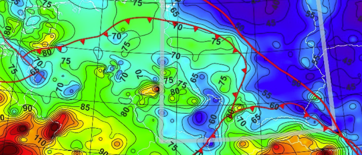
In Figure 1 (below) the present situation is compared to that close to the Jurassic-Cretaceous boundary, around 145 million years ago. Triangles represent horst structures mapped from seismic and their position is projected back to that time. Although this is an illustration, the cluster of high mounts formed in the middle of the strait between Madagascar and Africa seem to have created a network of scattered islands that subsided later in Miocene times (Figure 1b). Did some of those islands, not just the Davie Ridge crests, remain above sea level until the Eocene? Rock analysis supports this. Detailed geological descriptions of dredges and cores along the Davie Ridge were published in the late ’80s and early ’90s and rock samples were recently correlated with seismic, gravimetry and airmag.
Figure 1
Could clusters of seamounts seen on seismic indicate islands?
(a) Green, brown and yellow triangles represent western, central (Davie Ridge) and eastern Mesozoic horst structures below Cretaceous sediments; yellow trapezoids are young volcanoes, all mapped as found now.
(b) Reconstruction at the Jurassic–Cretaceous boundary position of Madagascar relative to Africa. The cluster of horsts which formed in the middle of the strait between Madagascar and Africa seems to have favoured the creation of a network of islands that subsided in Miocene times. (Jurassic – Cretaceous boundary position of Madagascar relative to Africa close to the time of magnetic anomaly (M17) after Coffin & Rabinowiz, 1987. Faults with north-west to south-east direction after Raillard, 1990 and Rusk, Bertagne & Associates, 2003.)
Understanding the surface environment has important implications for biodiversity. Zoologists still question whether ‘evolutionary bridges’ allowed mammalian groups to pass from Africa to Madagascar in Eocene times. The presence on Madagascar of several terrestrial mammalian groups with poor dispersion capacity across wide water barriers led several authors to suggest the existence of land-bridge connections between Africa and Madagascar during Middle Eocene to Early Miocene, (47–26 Ma), rather than assuming the rafting on vegetation mats hypothesis. This debate moved recently from classical taxonomy to genetic molecular comparative studies.
Plate reconstructions brought arguments constraining the ‘evolutionary bridges’ scenario, but rock descriptions from the Davie Ridge crests and flanks suggest there were long emersion periods. This in turn could indicate that until the Late Cretaceous and probably Eocene, the Rovuma Basin, today off the Mozambique and Kenyan coast, was somehow isolated from the Angoche Basin, now found off the Mozambique coast, and from the Morondava Basin, which is now off the Madagascan west coast, by a number of islands.
During the Palaeogene these islands could have restricted the eastward Mozambique palaeocurrent at latitudes south of today’s 19°S. It is possible that the Middle Eocene circum-Antarctic current between Australia and Antarctica, although it disrupted ocean currents worldwide and caused global cooling, could not strongly affect sea and land north of 19°S in the Mozambique Channel. Under these conditions the presence of a series of small, scattered Mesozoic-Cenozoic islands or remnants of them in the middle of the channel, combined with the eastward Mozambique palaeocurrent and wind circulation in the Palaeogene, favours the migration of mammalian groups from Africa to Madagascar.
Evidences of Emersion
Late Jurassic to Miocene formations and structures in the Mozambique Channel are visible on seismic. However, knowledge of the nature of the rocks and their crystals and the erosion that had a hand in shaping the peaks is not available without sampling, dredging, coring or drilling.
Figure 2
Example of W-E seismic line across the Mozambique Channel.
(For line of section see Figure 1)
(For line of section see Figure 1)
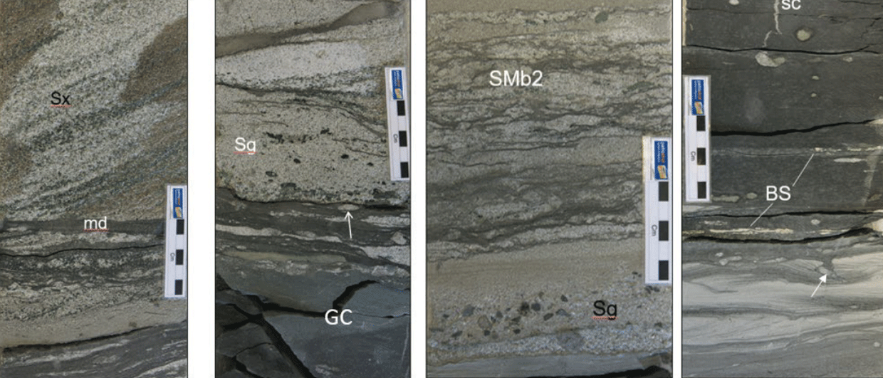
The eroded crystalline basement was dredged from depths of 2,450 to 1,875 mbsl and recovered recrystallised pelites, arkosic laminites with clasts of gneisses, lithified black psammitic beds and calcareous sandstones covered by Middle to Late Eocene carbonates and Pleistocene oozes. The Angoche Basin is situated east of the western flank of the ridge. Today the vertical fault displacement at the western flank of the ridge exceeds 1 sec TWT. The eastern slopes of the ridge denote several unconformities and possible later mass-slides. The absence of onlap around the volcano in the east indicates a young age.
Dredge sampling of the sedimentary blanket of the Davie Ridge has revealed that the volcanic crests of the northern part of the ridge (around 14°S) remained close to or above sea-level for long periods and were covered by Miocene breccia, conglomerates and carbonates (Figure 2, above). Meanwhile, the crystalline basement of the crests at the median parts of the ridge (between 15° and 16°S) has been shown to have been eroded and there are outcrops of arkosic sediments, recrystallised pelites and flysch-like black psammitic beds, Upper Eocene bioturbated calcareous sandstones and high energy calcareous breccia below Late Miocene oozes (Figure 3, below). The southern crests of the ridge (between 17° and 19°S) were covered by highly altered basaltic breccia cemented in a carbonate matrix and by Middle Eocene platform carbonates below Early Miocene limestone.
Figure 3
Example of NW-SE seismic line across the Mozambique Channel.
(For line of section see Figure 1)
(For line of section see Figure 1)
The large volumes of sediments deposited on the flanks of the ridge derive from the erosion that affected the Jurassic mountains during Cretaceous-Eocene times.
The Paleocene is absent on the ridge and was not found by DSDP Leg 25, implying that a major unconformity has to be considered between the Cretaceous and the Paleocene. The local distensions which accompanied the drift of Madagascar and the lithospheric fissuring were both transgressive southwards, inducing either the first Cretaceous pelagic sedimentation or hypabyssal to subaerial volcanic activity. The northern part of the ridge around 14°S remained close to sea level until the Miocene. Volcanic activity was present at the northern and southern parts of the ridge although in the middle, around 16°S, the eroded crystalline basement was not penetrated by volcanics, and Late Cretaceous sedimentation was prominent on the eastern flanks. Eocene outcrops are better exposed at the southern parts of the ridge between 17°S and 19°S.
Figure 4
Example of SW-NE seismic line across the Mozambique Channel.
(For line of section see Figure 1)
(For line of section see Figure 1)
This section shows that the Zambezi canyon was also fed by the eroded Davie Fracture Zone.
The Roles of Compression and Erosion
With a 1,000 km drift of Madagascar southwards along the fracture zone between 165 and 120 Ma, an average drift (half spreading rate) of 22 mm per year should yield extremely high convergent rates on the transpressional segments of the fracture zone. This amount of shortening should be sufficient to uplift large blocks, tens of kilometres across, over thousands of metres, a process which has been examined in depth at the San Andreas fault. Consequently, the origin of some push-up blocks east of the Davie Ridge may be related not only to listric but also to convergent wrench faults and flower-like structures if a wedge tectonic system was present. Similar extensional and compressional structures were recognised north-east of the Davie Ridge on the Madagascar side, between 12° and 14°S as well as west of the Davie Ridge on the African side, at around 15°S.
The shaping of the mountains depends as much on the destructive forces of erosion as on the constructive power of tectonics. In Cretaceous times erosion of the mountains is thought to have removed large quantities of rock but the resultant uplift replaced about 80% of the mass removed. From seismic lines we estimate that the missing parts of folds together with vertical displacement suggest that the removed mass represents about one second of folded Jurassic and Karoo, that led to about 0.8 seconds, or around 1,500m, of isostatic uplift (Figure 3). A very general estimation indicates that 100m could be removed through erosion every 10 million years at an average low rate of 0.01 mm/yr.
The process of erosion around the volcanic islands was later influenced by deep faulting and sliding, affecting unstable slopes at depths that can exceed five kilometres. The occurrence of such large slides on the flanks of the Davie Ridge is connected with dissolution features of the carbonate terraces and platforms, and may be influenced by Cenozoic high-amplitude fluctuations of the eustatic level.
The Role of Magma Underplating
Part of this uplift may be related to magma underplating as well as to compression and erosion. Up and down movements of several hundreds of metres at plate edges can be explained by the mantle influence. Several cases of continental ‘bobbing’ during Cretaceous times have been observed around the globe. Mantle is, in fact, able to lift the surface by hundreds of metres, easily enough to cause an apparent drop in sea level.
In the case of the Mozambique Channel, basalts were emplaced after cessation of the southwards movement of Madagascar, apparently at a time of quiet when India separated from Madagascar at around 83 Ma. These basalts have alkaline affinities and were emplaced along pre-existing zones of weakness of the fracture zone under hypabyssal to subaerial conditions and in some cases suffered hydrothermalism. The crustal thickness between Africa and Madagascar seems to have inhibited the emplacement of huge volumes of magma along the fracture zone but in turn this could have favoured a Cretaceous uplift.
The beautiful island of Nosy Komba, Madagascar. (Source: 123rf/Lenise Calleja)
The Role of Eustasy
A sea level drop of a few hundred metres due to Middle Cretaceous eustatic changes would narrow the channel only slightly to reveal few islands. However, the combined effects of tectonic activity, sediment accumulation/compaction and eustasy on accommodation changes can be important on a regional scale, with rates varying from several to tens of metres per million years. The Cenomanian-Turonian interval was punctuated by large and rapid sea level drops. High-magnitude and short duration changes (tens of metres in <100,000 years) are known, resulting in ‘absolute’ rates of sea level change in the order of 150–1,000 m/Ma.
The rise in sea level due to sea floor rise as a result of oceanic crust global events did not compensate for uplift along the Davie Ridge. From the Eocene and through the early Miocene, water retreat left deposits of limestone and chalk, while basalts were eroded and brecciated and the fragments were deposited in a carbonate matrix, dated by nannoplanktons to be Middle Eocene. The presence of limestones and chalks at the southern parts of the ridge can be explained by this mechanism. It is important to note that these rocks were dredged at present depths of between 2,450 and 600m, which do not represent the shallow depths of deposition.
From the Miocene these islands started to sink to finally form present-day seamounts, atolls and islands.
Hydrocarbon Implications
The Mozambique Channel. (Source: 123rf.com/Anton Balazh)
The Cretaceous ocean floor rise, although helped by an increase in carbon dioxide, a Middle Cretaceous important greenhouse episode and the deposition of limestone, did not compensate for the large uplift due to compression and folding which has been observed in several parts of Gondwana, including the Cretaceous Mozambique Channel. Many geological processes have taken place between East Africa and Madagascar since Jurassic times, and although today the channel is a huge marine environment, these processes can be observed in the rock history. Even if the amplitude of lithospheric thinning was the guiding mechanism for volcanic activity along the Davie Fracture Zone, both the basement reactivation and the volcanic activity along the fracture zone were controlled by the amplitude of uplift and erosion. From a petroleum exploration standpoint, the size of this uplift may have enormous consequences for the Mesozoic depositional environments of the Mozambique Channel.
The Majunga and Rovuma Basins were probably isolated from the Angoche and Lacerda Basins and from the Morondava Basin with distinctly different sedimentary and diagenetic histories until the Middle Miocene, which has important implications for hydrocarbon exploration.
The presence of a series of small, scattered Mesozoic-Cenozoic islands in the middle of the channel, across which mammalian groups could migrate from Africa to Madagascar, brings some new support onto the land-bridges theory. There was perhaps an initial period of around 20 million years, until the Jurassic–Cretaceous boundary, when biotic exchange would have been present between western and eastern Gondwana, followed by a second period during the Eocene that preserved emerged parts of the Davie Ridge and of its eastern slopes.
It is clear that the Mozambique Channel still holds a number of secrets and there is scope for considerable further research.
Acknowledgements
Cruise MD39 was funded by the Territoire des Terres Australes et Antarctiques Françaises in 1984. Seismic has been available courtesy of CNRS-IPGS/GeoAzur. Rock geology was based on 63 cores and 15 dredges recovered during the R/V Marion Dufresne cruise (MD39) in 1984 and the R/V Suroit cruise (SU2) in 1979.
Dredged rocks and cores from the Davie Ridge are preserved in the Marine Rock collection of the National Museum of Natural History (Muséum National d’Histoire Naturelle) in Paris.
Bibliography
Crystalline basement and intraplate mesozoic magmatism of the Davie Fracture Zone. Y. Bassias and L. Leclaire in Neues Jaarbuch fur Geologie und Palaontologie Mh., 2, 67-90, 1990.
Petrological and geochemical investigation of rocks from the Davie fracture zone (Mozambique Channel) and some tectonic implications. Y. Bassias in Journal of African Earth Sciences and the Middle East. 15, 3–4, 321-339, 1992.
Mountain Building. E.A. Keller and N. Pinter in Active Tectonics: Earthquakes, Uplift and Landscape. Second edition. Prentice Hail, 2002.
The Threat of Silent Earthquakes. P. Cervelli in Our Ever Changing Earth. Scientific American special edition. 15, 2, 2005.
Mammalian biodiversity on Madagascar controlled by ocean currents. Ali JR and Huber M. in Nature 463, 653-657, 2010.
A search for Origins. I. Tattersal in Elwyn Simons. Eds. J. G. Fleagle and C.C. Gilbert, Springer, 397-408, 2008.
The Davie Fracture Zone and adjacent basins in the offshore Mozambique Margin – new insights for hydrocarbon potential. E.S Mahanjane in Marine and Petroleum Geology. 57, 561-571, 2014.
Study updates uplift-erosion correlation, Davie fracture zone. Y. Bassias and R. Bertagne, in Oil & Gas Journal. 54-67, Sept. 7, 2015.
How to identify oceanic crust-evidence for a complex break-up in the Mozambique Channel, off East Africa. J.Klimke, D. Franke, Ch. Gaedicke, B. Schreckenberger, M. Schnabel, H. Stollhofen, J. Roses, M. Chaheire in Tectonophysics. (in press).
Tectonics of Strike-Slip Restraining and Releasing bends. P. Mann in Geological Society Special Publication, 290, 239-253, 2007.
Short term sea level changes in a green house world-A view from the Cretaceous. B. Sames, M. Wagreich, J.E. Wendler, B.U. Haq, C.P. Conrad, M.C. Melinte-Dobrinescu, X. Hu, I. Wendler, E. Wolfgring, I.O. Yilmaz, S.O. Zorina in Paleogeography, Paleoclimatology, Paleontology, 441, 393-411, 2016.
La ride de Davie dans le Canal de Mozambique: Approche stratigraphique et géodynamique. L. Leclaire, Y. Bassias, M. Clocchiatti, J. Segoufin in C.R. Acad. Sci. Paris, 308, II: 1082-88, 1989.
The role of molecular genetics in sculpting the future of integrative biogeography. B. Riddle et al. in National Science Foundation Workshop (DEB-0639022), 2007
Cretaceous Eustacy revised. B.U. Haq in Global Planet Changes, 113, 44-58, 2014.
Implications of recent geological investigations of the Mozambique Channel for the mammalian colonization of Madagascar. R. A. McCall, in Proceedings of the Royal Society of London. B 264, 663-665, 1997.
Reconstruction of Madagascar and Africa. evidence from the Davie Fracture Zone and Western Somali Basin. M.F. Coffin and P.D. Rabinowitz J. Geophys. Res., 92, 9385-9406, 1987.
Seaward extension of the East-African rift. Mougenot D., Recq M., Virlogeux P. at Lepvrier C. in Nature, 321, 599- 803, 1986.
Reconstruction de l’Océan Indien occidental pour les époques des anomalies M-21, M-2 et M-34. Paléo-position de Madagascar. J. Segoufin and Patriat in Bull. Soc. Géol. France, XXIII, 6, 603-607, 1981.
The Africa–Madagascar connection and mammalian migrations. P.D. Rabinowitz, S. Woods in Journal of African Earth Sciences, 44, 270-276, 2006.
The Davie Fracture Zone – Island connections in Mesozoic and Cenozoic. Y. Bassias in The Geological Society: East Africa – From Research to Reserves, 127-130, 2016.
Dynamics of Cretaceous Vertical Motion of Australia and the Australian-Antarctic Discordance. M. Gurnis et al. in Science, 279, 1499-1504, 1998.
The nature of the crust offshore East Coast Africa – when geology and seismic meet potential fields in the search for hydrocarbons. Y. Bassias, G. Roberts and T. Christoffersen in The Geological Society: East Africa – From Research to Reserves, 124-126, 2016.
Les marges de l’Afrique de l’Est et les zones de fracture associées: Chaine Davie et Ride du Mozambique. S. Raillard, Ph.D. Thesis, Laboratoire de Géodynamique sous-marine Villefranche-sur-mer. 1990.