Bringing world-class geological field locations into the classroom using virtual reality technology.
‘The best geologist is the one who has seen the most rocks’ is a mantra often repeated to student geoscientists. Sadly, not everyone has the opportunity to undertake field trips, and are therefore not benefiting from the learning opportunities and skills development gained from conducting measurements and observations in the field environment.
Why Make Geological Field Trips Virtual?
A photograph of part of the outcrop at Little Hilbre. Credit: Carol Hopkins.
PetroEDGE provides technical training to the oil and gas industry through taught courses, workshops and field trips, but recently there has been a significant decrease in the number of requests for field trips, primarily due to a reduction in training budgets. Since virtual reality (VR) modules focusing on facilities and equipment were already available, it was decided to extend this to VR geological field trips, presented in a style consistent with physical field trips.
The Hilbre Islands off the north-west coast of England were chosen as a pilot location. They are well visited by field groups, and of particular interest to oil and gas geoscientists as they comprise the Lower Triassic Ormskirk Sandstone Formation of the Sherwood Sandstone Group, which is producing oil and gas from fields 25 km away in the East Irish Sea Basin.
The VR field trips are intended to create an immersive and realistic environment designed to encourage exploration. Users are supplied with a virtual field guide, accessible at all times, and have access to various tools to make appropriate measurements. Guidance at the start of the field trip encourages the user to make the same observations they would in the field and to develop their fieldwork skills. Areas of particular interest have ‘hotspots’ providing more detail when selected, such as core or log images, photomicrographs, depositional models, illustrations of sedimentary structures, or annotation of the outcrop. The range of information that can be displayed in the hotspots is vast, and can include video footage, seismic imagery, animations and 3D models.
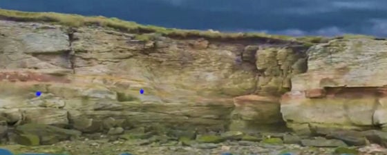
A screen shot of the start of the field trip. The annotation (right of the picture) and voice-over encourage users to make observations from a distance before moving closer and exploring freely. The blue spheres are the hotspots that reveal further information or data when selected. The white line is a 1 metre measure for scale, augmented by a linear measuring tool. A video flypast is also available. Source: PetroEDGE.
The Challenges of Virtual Reality Field Trips
There are numerous VR field trips available, with different strengths and disadvantages. Many exploit the freedom, scale and accessibility that drone image capture can provide; this has certainly excited me as, having spent years assuring field trip attendees of the features that can be seen at the top of outcrops, we can finally fly up and see for ourselves.
A screen shot of the paint palette, interactive map and tool selection palette, all attached to the handsets. The user’s location and field of view are displayed on the map, along with a tab to move to another locality (Little Hilbre). Source: PetroEDGE.
Our initial photogrammetric models did not provide high enough resolution when converted into VR, primarily because drones are unable to fly too near to outcrops and acquire close-up imagery. Many VR field trips have a resolution equal to 3 cm per pixel or lower, but to illustrate meaningful sedimentological features higher resolution is needed, and our aim was to resolve to coarse-grain size. Many months of experimentation with a combination of different methods of image capture and processing techniques achieved the required results, but also highlighted technical problems that would be encountered at future localities.
For example, the presence of deep shadows confuses the processing software as it relies on an algorithm that identifies similarities in adjacent areas. Occasional shadowed areas can be processed manually, but that process is time consuming and is best avoided whenever possible. Virtual field trips to carbonate outcrops in the Middle East are planned, but filming when the sun is high in bright conditions will produce numerous areas of deep shade contrasting with brightly lit areas, creating extensive processing problems.
On a conventional field trip, it is possible to move behind foliage and boulders to access the outcrop, but these can obstruct drone image capture, so can limit the selection of locations. Also, some of the filming requires access to the outcrops on foot and cannot rely on flying drones into less accessible areas if high-resolution imagery is required.
Lengthy filming and processing of large outcrops can be overcome by using a combination of VR with embedded fly-past and 360-degree videos. As the user is provided with a geographical map, different sections of more extensive outcrops can be imaged and the user is transported to each area when selected on the map.
Integrating Virtual Geology Field Trips with Other Geoscience Training Methods
A screenshot of the opened field guide and a hotspot. The image in the hotspot is one of several photomicrographs of thin sections prepared from samples collected for the project. Source: PetroEDGE.
VR field trips cannot replicate all the skills transfer and learning opportunities provided by physical field trips, but we all need to be pragmatic in a changed financial landscape. Conventional field trips are costly in terms of travel, accommodation, downtime and logistics, so it is better to be able to experience many of the benefits of a field trip, albeit virtually, than to never experience them at all. The skills required to make appropriate observations and conclusions can still be taught, and serve as a reminder that the various data we are using elsewhere relates to real rocks and that interpretations should comply with our understanding of geological processes.
Using VR field trips to illustrate various aspects of training courses can be more incidental, allowing trainees to experience field trips as part of classroom courses or workshops, where travel to each locality is impractical or costly. VR modules can be tailored to include information pertinent to the course, or be integrated with other learning resources. However, it is vital that the VR field trips are valuable in their own right, and not just a new technology to play with. Unnecessary graphics and sound effects have been eliminated to help the user forget they are in VR and focus on the geology.
Flexibility of Virtual Reality Training Courses
The information in the hotspots and field guides can easily be tailored to different audiences, including non-geoscientists, engineers, administrative staff and geophysicists. Many of these groups might not normally attend conventional field trips, but do attend classroom courses that can be enriched by examining real rocks.
The field trip leader can be in the classroom with attendees, or can join them remotely, guiding the trainees in the same way as on a physical field trip. However, the VR field trips are designed as stand-alone modules that can also be accessed by an individual without any need for a leader or instructor. Undertaking a particular module can be used as a refresher for staff, to acquaint themselves with a new environment of deposition, or as part of their personal development programme. VR field trips may also be used to equip students with field skills or to familiarise them with the locations prior to a real field trip. This serves to build their confidence and maximise their time in the field. They can be reviewed many times and help to refresh understanding, or provide easy comparison between different localities.
There is also interest from various organisations anxious to preserve educational outcrops that are threatened by weathering, quarrying or development. Putting these outcrop into VR ensures access for future students and field trippers, and provides consistency for any teaching modules that utilise these localities.
Includes All Geoscience Team Members
When planning a physical field trip, it can be difficult to include access to a number of good outcrops that tell a coherent story, while restricting the amount of travelling between localities. With VR field trips, a wide range of geographical locations can be combined to provide a comprehensive understanding, or for comparison of different localities.
The cost of creating VR field trips is mitigated by the unlimited number of users able to access each trip, the absence of travel and logistical costs, and the variety of roles the VR field trips can fulfil.
It must be stressed that VR field trips are not intended to replace physical field trips, but do provide additional features, such as aerial and panoramic views, and the ability to overlay data, interpretation and models onto the outcrop. They also provide inclusive access to less mobile users, or those unable to travel. Inclusivity also extends to non-geoscientists, junior staff and others who may not normally get an opportunity to visit the field. Remote localities, outcrops with restricted accessibility or ones that present particular health and safety risks can still be experienced, providing the filming team can overcome these issues safely.
However, virtual reality field trips should not just be considered a cost-effective, risk-free alternative to real field work. They offer unique opportunities to incorporate activities and features unavailable in the field, and deliver a more integrated and flexible learning resource.


