The Mexican Comisión Nacional de Hidrocarburos (CNH) announced its first ever licensing round (Ronda Uno) in August 2014, with a view to bolstering exploration investment, especially in the offshore region, but also onshore where unconventional resource exploration has been initiated in the Burgos Basin.
The round is phased, with shallow water blocks in the South East Basin being offered first, and data packages are now available. The CNH is looking for participation with a minimum bid that must comprise at least two commitment wells on the first phase of released blocks. Despite these requirements the round is expected to be highly competitive because of the prospective acreage on offer.
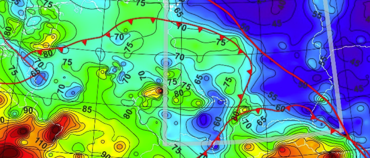
The Ronda Uno blocks are scattered throughout most of the offshore basins in Mexico. A vast amount of 3D seismic data now covers most of the prospective areas offshore Mexico, so future exploration will be accelerated by access to these data sets (Figure 1). There are very few wells in the deep offshore, including fewer than 10 wells in water depths greater than 1,500m, so this is almost virgin exploration territory in basins with vast petroleum potential.
We will now look at the geology and potential of the prime areas offered in this round.
Perdido Fold Belt
Some outstanding blocks are being offered in the Perdido Fold Belt (Figure 2), where Pemex has made five new light oil discoveries in the last two years, since the ground-breaking Trion-1 discovery in August 2012, which is believed to contain 350–500 MMbo in place.
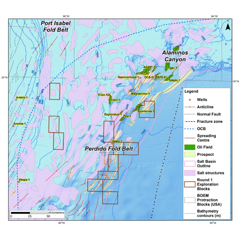 Figure 2. Map of the Perdido Fold BeltThe offshore Perdido Fold Belt was produced by downslope gravity gliding during the Oligocene, which followed the Laramide (Hidalgoan) orogenic mountain-building event in the latest Cretaceous to Paleogene. The eastern Sierra Madre Fold and Thrust Belt created a topography probably 3–4 km high onshore along the western shores of the Gulf of Mexico, which destabilized the margin. A 4–5 km thick section of sediment had already been deposited on top of the Callovian-age salt before folding, which occurred after deposition of basin floor stacked channel fan complexes with turbidite sandstones in the Eocene and early Oligocene Wilcox Formation. Reservoirs can therefore be expected to be present across the crests of some of the fold structures. The reservoirs in the Trion-1 well were reported to have 18–25% porosity, 250 mD permeability, and capable of flow rates of 10,000 bpd, although to our knowledge no drillstem tests have been performed to date.
All of the Perdido blocks currently offered in Ronda Uno sit in the frontal part of the fold belt where the folds detach on autochthonous Callovian salt (Figure 3). The main source rocks for the light oil is believed to be the Tithonian-age Pimienta Formation, but could also be possibly derived from Kimmeridgian-Oxfordian marine shales which are buried to 5–6 km depth. Localized extensional faults were generated in the outer arc area of the fold crests, which provide migration pathways for the oil into the overlying Wilcox reservoirs.
Burgos Basin
Farther up dip, in the Burgos Basin, the same Wilcox play is predicted to occur below a thick canopy (3–4 km) of allochthonous salt (Figure 3). Seismic imaging is good enough to identify large sub-salt folds.
The Jurassic source rocks are buried to depths of 8–9 km below seabed, which, at first glance, would suggest the basin would be gas prone as the source rocks are overmature, but the extrusion of the salt in the Miocene could have cooled down the sub-salt section since this time. This is because salt is approximately three times more thermally conductive than shale at shallow depths, and the geothermal gradient through the salt will be only 8°C/km. Hence, the Tithonian and Cenomanian-Turonian source rocks may still be mature for light oil generation, even at this great depth.
Sub-salt targets will be located 6–7 km below seabed, but the reservoirs may be highly overpressured, which may have preserved some porosity in the deeply buried Wilcox reservoirs. Three blocks have been offered in this basin, which are all thought to have allochthonous salt sheets present.
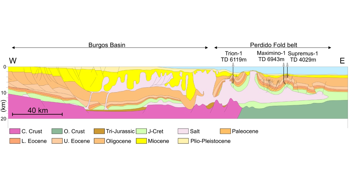
Figure 3. Cross-section through the Burgos Basin and Mexican Perdido Fold belt, showing some of the important new discoveries.
Mexican Ridges Fold Belt and Veracruz Basin
The Mexican Ridges Fold Belt (Figure 4) and the Veracruz Basin were also affected by the important gravity gliding which started in the Oligocene with updip listric faulting and downdip folding and thrusting. The gliding sediments were detached on a Paleogene shale horizon which is probably still overpressured, as gliding is still occurring at the present day, causing important folding of the seabed. This raises a question as to whether an oil play will be present in this basin, because the Tithonian and Cenomanian-Turonian age oil-prone source rocks lie below the detachment which probably acts as a regional seal horizon. Oils trapped below the detachment would migrate landward to the shelf break where extensional listric faults provide a migration pathway to roll-over anticline structures. Surface oil slicks are present along the extensional fault trend, but there is a notable absence of surface oil slicks in the fold belt.
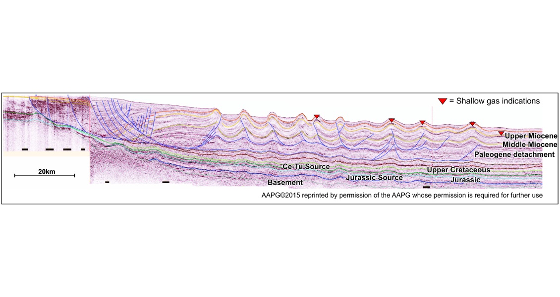
Figure 4. Mexican Ridges Fold Belt. The fold belt is probably lying on oceanic crust.
Campeche Salt and the South East Basins
The offshore Campeche and South East Salt Basins cover a vast area (230,000 km2) of the south-east offshore area. The Callovian-age salt is the conjugate to the USA and Burgos Basin salt, with the two salt basins subsequently separated by ocean floor spreading which began in the Late Jurassic. The basin is bounded to the east by the Yucatán Peninsula, a continental block which rotated anticlockwise by at least 30° during ocean formation.
The oil is quite heavy (10–25° API) in the Cantarell and surrounding areas, which is believed to be due to early expulsion of the oil from the Tithonian source rock, rather than biodegradation. Folded and thrusted Mesozoic carbonates are present throughout the Campeche salt basin and the Cantarell type play has not been tested in the deepwater so far.
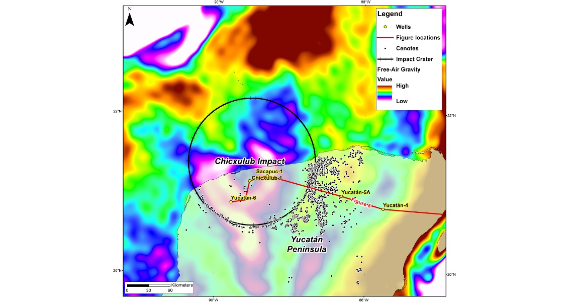
Figure 5. Map of the Yucatán Peninsula and the Chicxulub meteorite impact. Cenotes are natural sinkholes resulting from the collapse of limestone bedrock due to meteorite impact.
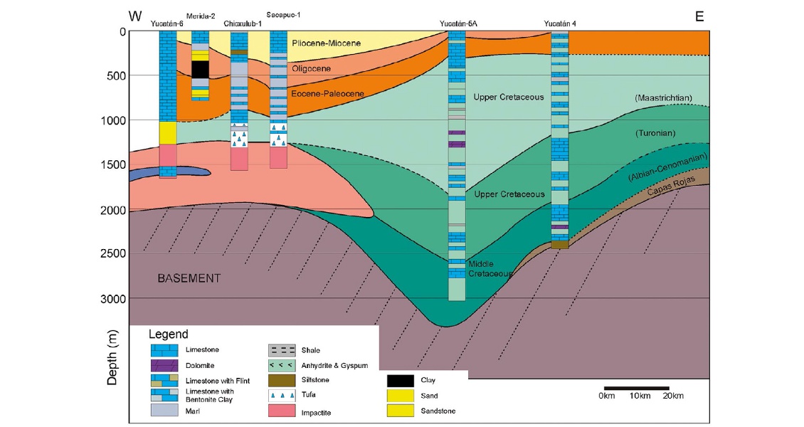
Figure 6. Cross-section across the Yucatán Peninsula. See Figure 5 for location (From Lopez Ramos, 1975).
The deepwater Campeche Salt Basin has been hardly explored to date, with only two ultra-deep water (>1,500m) wells, both drilled in 2014. Yoka-1 was drilled in the frontal folds along the western edge of the salt basin and was reported to be a subcommercial gas discovery and Lakmay-1 was a dry hole drilled in the center of the salt basin. There are many allochthonous salt sheets in Campeche and the South East Basin, but to our knowledge no sub-salt wells have been drilled so far. The allochthonous salt sheets were mainly extruded in mid-Miocene times and then folded, with compression continuing to the present day.
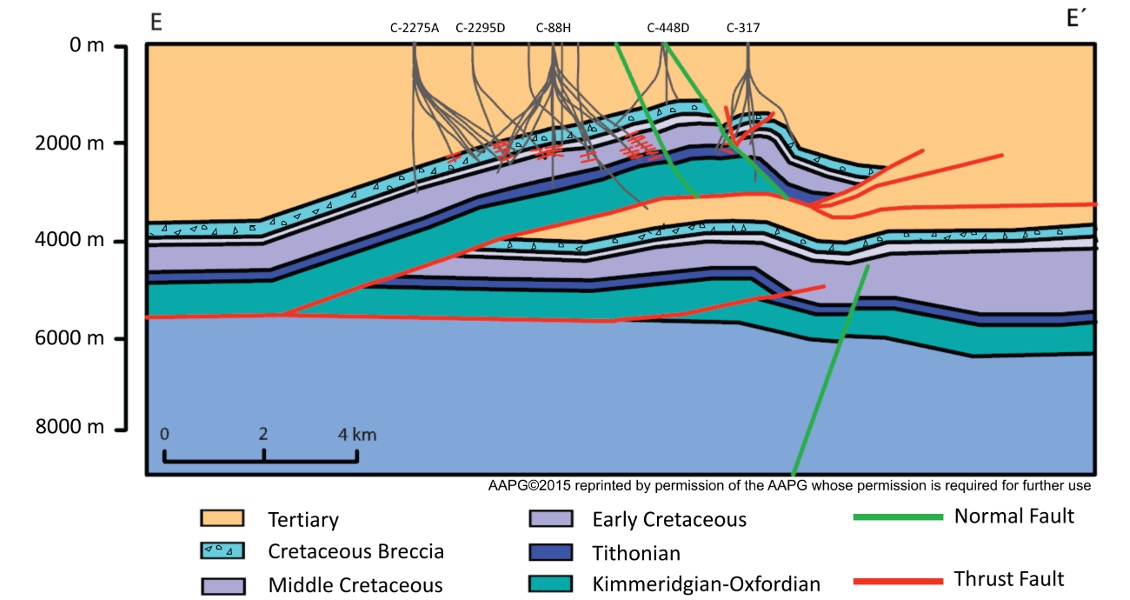
Figure 7. Cross section through the Cantarell field (after Mitra et al. 2005)
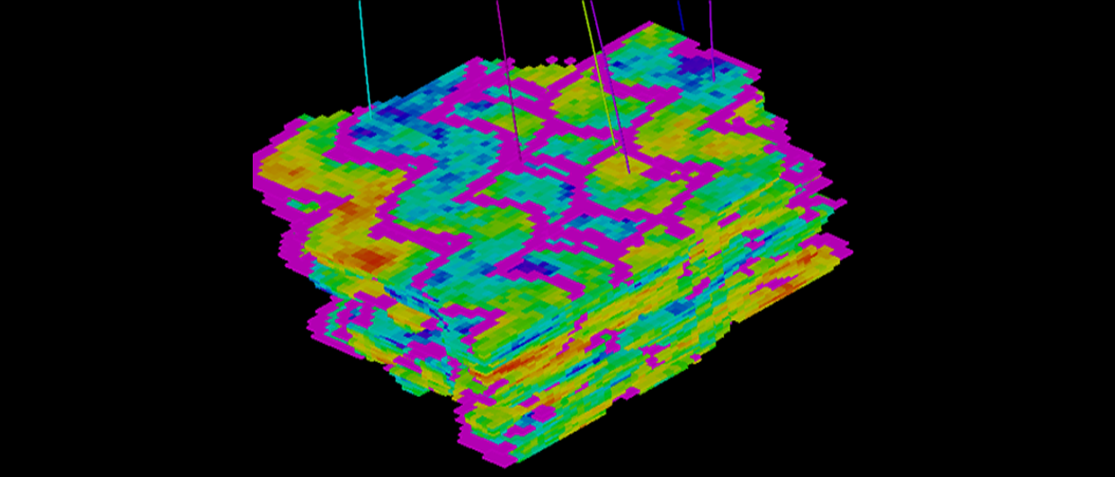
Rapid deposition of Pliocene to Recent clastic sediments further enhanced the deformation of the salt sheets, forming deep minibasins in the South East Basin; up to 5 km of sediment has been deposited in the last two million years. The corrugated base and top of the salt sheets have different shapes which makes single azimuth 3D seismic imaging very difficult, and the underlying structures are poorly imaged (e.g. Gomez-Cabrera and Jackson 2010, Figure 8). Better quality multi- or wide-azimuth 3D seismic data will be required to image the structures below the salt sheets to image the traps and identify if mid- and early Tertiary sandstone reservoirs are present. Fourteen of the blocks being offered in the South East Basin are dominated by deformed allochthonous salt sheets.
The blocks are also in a region of large Miocene channel systems which transported sand from the uplifted Chiapas massif and fold belt and this area is considered to have excellent potential for sub-salt plays in shallow water.
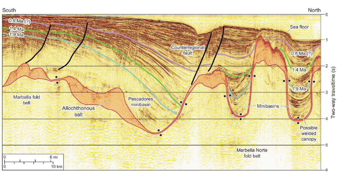
Figure 8. Cross-section through the South East Basin. (From Gomez-Cabrera and Jackson, 2009, AAPG©2015.)
An Historic Event
The opening of the Mexican offshore for exploration is a historic event and undoubtedly the better blocks in the opening Ronda Uno will be highly contested. A recurring theme in many of the offshore areas is the presence of large allochthonous salt sheets which have complex deformed geometries. The use of new seismic acquisition techniques using multi-azimuth,and/or wide-azimuth shoots will hopefully reveal much more of the underlying structures and lead to some bold wells testing these large sub-salt plays in the coming years.
This article stems from a regional multi-client study of the hydrocarbon potential of Mexico; further details can be obtained on the Earthmoves website.