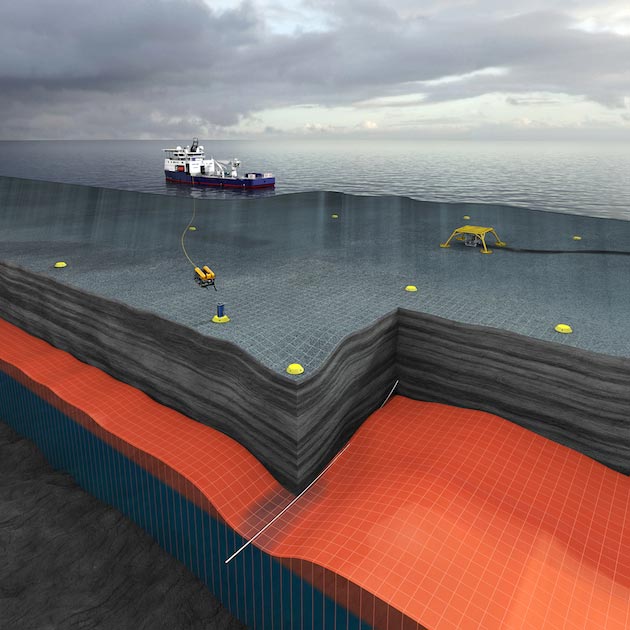
Conceptual picture of water influx in reservoir during gas takeout. Water replacing gas in the reservoir will lead to large density changes, which can be detected by timelapse measurements of gravity at the seafloor.
Conceptual picture of water influx in reservoir during gas takeout. Water replacing gas in the reservoir will lead to large density changes, which can be detected by timelapse measurements of gravity at the seafloor.
Conceptual picture of water influx in reservoir during gas takeout. Water replacing gas in the reservoir will lead to large density changes, which can be detected by timelapse measurements of gravity at the seafloor.
Geophysical data available for reservoir characterisation and for the monitoring of offshore reservoirs are mainly represented by seismic and electromagnetic data. Gravity data is currently emerging as an additional and independent source of information after proving its value through numerous gas monitoring projects offshore. The increasing success of gravimetric surveys as an integrated part of reservoir monitoring programmes can be explained by new technological developments, enhanced software for data processing and experience from years of field case studies. With the superior acquisition design and data quality, important information related to reservoir performance such as the volume of available reserves, fluid flow, identification of depleted parts of the reservoir and seafloor subsidence can be found with greater confidence. This will lead to enhanced recovery of the reservoirs.
Gravity and Pressure Data
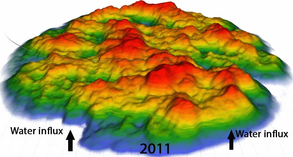
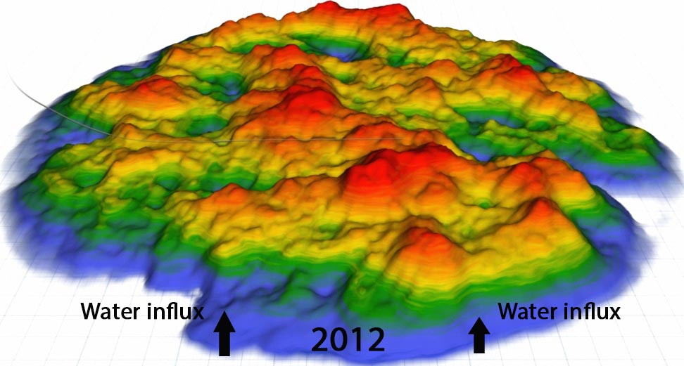
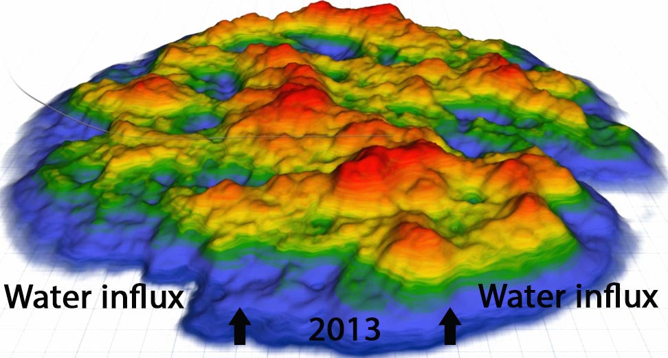
During a gravimetric survey, gravity and pressure data are measured at selected locations on the seafloor above the target of interest. Gravity data yield information about the density distribution in the subsurface and can be utilised to delineate subsurface structures and fluid distributions. By performing time-lapse gravity surveys, the changes in the density of the subsurface are monitored. The information revealed is seen to be highly valuable for identification of production-related changes in the reservoir such as water influx, fluid flow, pressure buildup and reservoir compaction.
Short video illustrating how hydrocarbon production leading to water influx results in subsurface subsidence that creates gravity and pressure changes, providing information on reservoir compartmentalisation and barriers to flow.Gas takeout will in general lead to pressure reduction. This effect may be counteracted by water influx from surrounding aquifers. Hence, uncertainties on the aquifer strength and potential influx mechanisms can be reduced by interpretation of gravity changes at different locations of the reservoir. Moreover, if evidence of pressure depletion is found in one region of the reservoir whereas other regions are not affected, this may indicate compartmentalisation or barriers to flow and provide information on fault block transmissivity.
The acquired pressure data provides accurate measures of seafloor subsidence and in several studies changes in seafloor elevation with subcentimetre accuracy have been obtained. The pressure data is also important for improving the accuracy of the gravity data by reducing noise introduced by density variations in the water column and providing valuable corrections to modelled astronomical tide effects.
Acquiring the Data
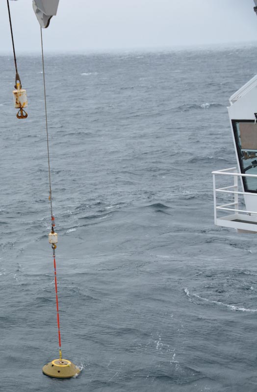 Deploying concrete stations from a survey vessel.The layout design for the acquisition of gravity and pressure data is done by a pre-survey feasibility study where the focus is to ensure best possible illumination of the target area. Typically, this is performed in collaboration with the asset team of the field by optimising the gravity model towards the reservoir model. As a result of this study, it is possible to estimate the distance between and the number of seafloor locations, or stations, which will be needed for obtaining data within predefined uncertainties.
The acquisition itself is done by deploying a package of sensors at the different seafloor stations where the interval and frequency of the station visits will be determined by the main objectives of the survey. During data acquisition, the sensors are connected to the survey vessel through cables attached to a remotely-operated underwater vehicle (ROV) for continuous data recording. Compared to other geophysical services, the cost associated with operation and equipment is low.
A key factor for reducing uncertainties and to ensure acceptable 4D results is to have as accurate information about the location of stations and sensor tilt as possible. For the repeatability of measurements, efforts are taken to make the seafloor stations stable over time and state-of-the-art gauges for measuring tilt and automatic leveling of the sensor package are developed. We have already seen an exceptional improvement in data accuracy both due to improved data acquisition and processing. Today it is possible to obtain a level of accuracy in the gravity and pressure data which can enable the identification of as little as a one metre rise in the water gas contact under right conditions.
In addition to the spatial coverage of the data, the strength of the attainable gravity signal depends on factors such as the volumetric extent of the target, the density contrasts within the reservoir, and reservoir depth. For flow monitoring, a large density contrast between fluids will increase both the lateral and vertical resolution. Hence, this methodology is especially suited for monitoring gas reservoirs and also for CO2 sequestration projects.
New Yet Mature Technology
Gravimetric data for offshore reservoir monitoring has proven valuable through years of research and field applications on the Norwegian continental shelf. The procedures for data acquisition and data processing were developed mainly by Statoil ASA and Scripps Institute of Oceanography at the University of San Diego. Until now, the technological development has been driven mainly for research purposes, but the technology has now reached a stage where it is mature and ready to be commercialised worldwide.
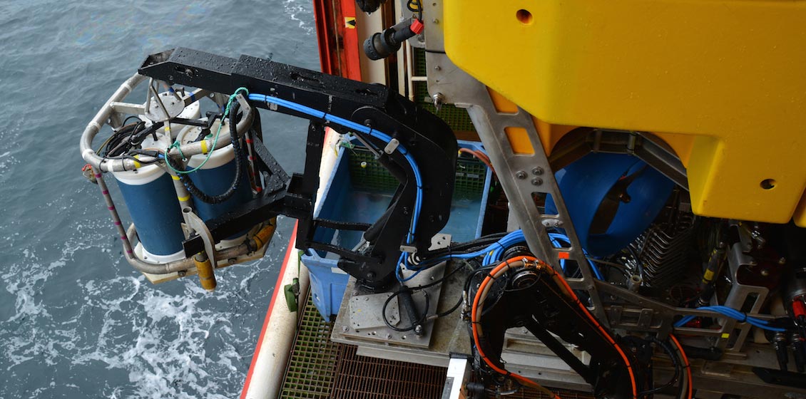
Launch of ROV with gravimetric sensor package.
As a result, Gravitude AS was launched in 2012 by Statoil ASA as an independent technology company to bring this expertise forward and commercialise the services. Today Gravitude AS offers gravimetric surveys on the same basis as other geophysical services. The company aims at further developing this technology by offering a complete acquisition package including survey management, data acquisition and processing. The services can include detailed gravity/density modelling towards dynamic reservoir simulation models.
Affordable Data
Why are gravity data interesting and emerging as a preferred technology on several of the world’s larger gas fields?
Gravity data are well proven and work well on a standalone basis. Due to the low cost of gravimetric acquisition and processing, gravity data can be acquired more frequently than seismic data. The latter provides information about the elastic properties of the reservoir, and a prerequisite for accurate interpretations on other reservoir properties such as saturation and pressure is to get the density profile as correct as possible. Gravity data offer direct measurements of the density of the reservoir, and hence will be a very valuable tool for assisting and constraining seismic data interpretation. Another advantage of gravity data as compared to, for example, electromagnetic measurements is that it is relatively insensitive to existing seafloor installations such as pipelines and well paths, which makes it a viable option for mature fields at a late stage of production.
 Schematic showing subsea assembly of typical 4D gravity survey. Compared to other geophysical services, the cost associated with operation and equipment is low.Gravimetric measurements provide a high lateral sampling density with coverage over the entire reservoir. Hence, in contrast to information such as well or core data, which provide point measurements at selected and restricted locations in the reservoir, gravity data offers information about both lateral and vertical variations within the reservoir. In contrast to active source geophysical data, the gravimeters do not require any ambient source to generate a signal; the signal measured is the fundamental gravitational force of the earth itself. No requirement for an active source coupled with a simplistic operational mode makes gravimetric surveys an affordable investment for most offshore reservoirs today. Moreover, the survey methods used are environmentally friendly with limited footprints and impact on the environment and animal life.
Gravity and pressure data are important tools for monitoring reservoir integrity and safety. Subsidence and uplift can be measured on subcentimetre scale and can be related to compaction and expansion in the reservoir. Compaction is one of the critical factors in managing reservoirs as it may have a potentially huge impact on the drainage properties. Surface deformation may be critical for installations on the field and by monitoring this it is possible to have an early warning system for any related hazards during operation.
Gravity Today!
High quality gravimetric services at low cost can be delivered all over the world by using state-of-the-art technology derived from gravity acquisition on the Norwegian continental shelf during the last decade by Statoil. An integrated package of sensors is used to measure gravity and pressure on pre-deployed concrete stations on the field. The package of sensors is handled by a ROV and depending on the size of field and weather conditions, a typical gravity campaign is one to two weeks. The processed data can be ready to be delivered within a week after a survey because of the fast and accurate measurement and processing of the data.
Since the beginning of development of the technology, there has been a large and continuing improvement in data quality for offshore gravimetric acquisition. Developments range from designing packages with state-of-the-art sensors, designing concrete stations, planning the survey operations, to processing of data, and today the repeatability of gravity data is as low as 1 μGal and subsidence can be measured on the millimetre scale!


