Innovative Technical Solution in a Dynamically Changing Industry
Unmanned Aerial Systems (UAS) have the potential to transform operational efficiency and technical solutions across the energy sector, and are providing an additional tool for training geoscientists.
UAS, more commonly known as drones, have now developed to the point where they can provide affordable and easily controllable platforms for all manner of aerial work that previously would have involved expensive manned vehicles such as helicopters or aeroplanes. Applications of this relatively new technology range from real-time inspection of inaccessible and remote infrastructure; remote sensing surveys for unexploded ordnance (UXO); topographic surveys for operational planning and environmental baselines, to providing 3D digital outcrop imagery for training purposes.
The benefits in cost-effectiveness, understanding, safety and security are significant to an industry which has undergone radical change during the latest down-cycle.
Drone in the process of capturing outcrop imagery. (Source: RPS Energy)
UAS in Training
The use of UAS has enabled RPS Nautilus to develop new methods of interactive training to improve understanding of the geological environment both in the field and in the classroom. The 3D digital outcrop models (DOM) derived from drone imagery and real-time video sequences allow students to interact with entire outcrops, thus complementing existing training materials and facilitating the learning experience when time, resources and cost are at a premium.
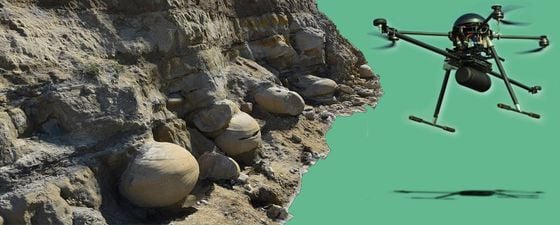
Extract from the DOM of the Bencliff Grit outcrop at Osmington Mills, Dorset. Large concretions or ‘Doggers’ are found at the base of the unit, while yellow-brown staining in the upper parts of the sandstones mark oil seeps and illustrates variations in permeability and the presence of barriers to flow. Sedimentary structures and architecture are clearly visible in three dimensions in the model. Access to this outcrop is restricted due to a high and periodically unstable rock face above. The Dogger in the foreground is about 1m in diameter. (Source: RPS Energy)
Aspects such as the understanding of scale, new viewpoints and perspectives on the relationships of rock units and access to otherwise inaccessible outcrops all serve to clarify, consolidate and enhance what can be learnt from the study of rocks at outcrop. The ability to manipulate scale from macro geology down to fine detail can deepen the learning experience for geoscientists and engineers in the field.
Classroom learning has been enhanced by the combination of 3D models from UAS photogrammetry, HD video fly-throughs, high resolution photographs and hand samples as well as the traditional paper maps and well logs, to provide a more interactive, multi-faceted and effective experience. In play fairway analysis training, for example, these innovative materials engaged participants by providing a hands-on approach to the understanding of petroleum systems and reservoir heterogeneity as applied to the creation of play fairway maps and risking.
Modern approaches to training such as this are proving to be very effective means of learning and can be improved further by the use of additional innovations including 3D visualization software, virtual reality (VR) and augmented reality (AR) techniques both in the field and the classroom.
Digital outcrop model (DOM) from the Culm Measures of south-west England. This aerial view provides a broad overview of the fold trains and overall structural style of the outcrop – a perspective not available from the ground. Zoom functions enable individual folds and their internal structure to be examined closely and ‘nested’ models can provide resolution to centimeter or even millimeter scale. Tides often constrain access to certain parts of the outcrop. Length of outcrop is approximately 1 km. (Source: RPS Energy)
Wide Area Operations
Drone with LiDAR attachment. (Source: RPS Energy)
The nature of these operations requires cost-effective and efficient solutions, which can range from initial screening through to camp and personnel security.
UAS systems provide a quick overview of an area or site to allow more detailed planning of ground survey and to aid in the planning of operations from line layouts to siting infrastructure. During operations drones can be effectively used to monitor progress and site security.
Research is ongoing into the use of drones for harvesting data as well as using these platforms for deployment and recovery of equipment. In these types of operations it is likely that a number of platform types would be utilized, ranging from short duration quadcopters to long endurance fixed wing assets.
The use of drones for exploration using gravity and magnetics is at an early stage, in part driven by the requirement to miniaturize the sensors so they can be mounted on the platforms, as well as the cost-effectiveness of UAS versus current technology. Drones may simply be just part of the solution.
From Unexploded Ordnance to Archaeology
Drone set up with case, controls etc. (Source: RPS Energy)
A game-changing use of UAS has been in the detection of unexploded ordnance, traditionally both personnel-intensive and risky. The use of unmanned and roboticized platforms alongside other solutions such as ground buggies has the potential to significantly reduce those risks and costs.
Currently, associated technology is developing rapidly, allowing more equipment and sensors to be carried on a drone. However, the need for stable and accurate flight and positioning requires significant detailed engineering, integration and testing.
Further applications for this technology are wide-ranging across all parts of the industry, from land fall survey for cable and pipeline shore landings to archaeological investigations during developments. Survey and inspection techniques can be enhanced by the use of UAS carrying a range of sensors from visual and infra-red cameras to LiDAR and laser scanning. The ease of use and cost-effectiveness means that these systems are increasingly being used during infrastructure inspections, from platforms to wind turbine blades.
Drone in flight with camera. (Source: RPS Energy)
Challenges
As well as the ability to miniaturize the sensors and the drone components, battery chemistry is still a major limiting factor, but fuel cell technology, amongst other ideas, is rapidly advancing. Integration of sensors and accurate positioning still remain key factors around the use of UAS in the energy sector but these challenges will be overcome as drones are finding their place as part of collaborative project solutions.
Further reading from GEO ExPro
Field-based Training: Luxury or Necessity? by Gary Nichols and Simon Baker, Nautilus Ltd.
What is the role of field geology today, what will it be in the future and what specifically is the importance of field-based training to petroleum geosciences? Is it a ‘luxury’ we cannot afford to give up? This article appeared in Vol. 12, No. 3


