Resolving Neogene clastic fairways
Using modern analysis techniques to understand the true potential of reservoir systems in a diverse basin.
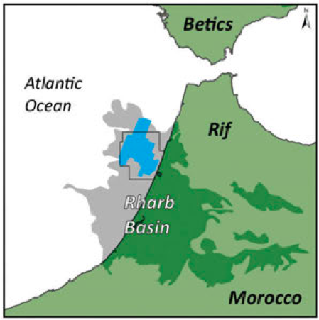
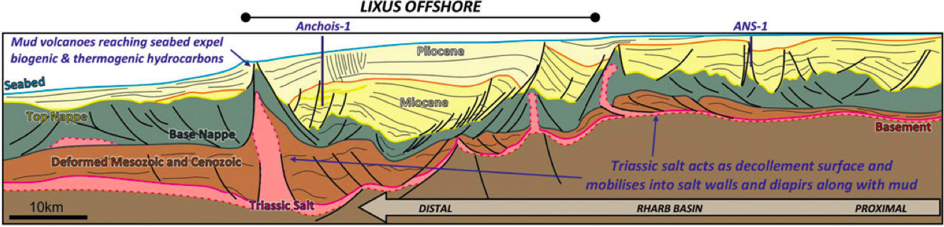
The Lixus Offshore block is located within the Rharb Basin on the north-west Moroccan Atlantic shelf (Figure 2). The Rharb Basin represents the westernmost foredeep of the African Rif Belt, part of the greater Betic-Rif-Tell range, which spans the Mediterranean margins of North Africa and southern Iberia. The focus of recent exploration throughout the Rharb Basin has predominantly been the post-nappe Neogene basins, so called as they are set atop a thick, argillaceous, olistostrome known as the Pre-Rifaine Nappe.
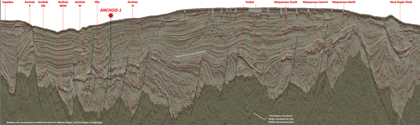
The significant Upper Miocene–Pliocene post-nappe section is dominated by deep marine sediments, composed of hemipelagic mudstones punctuated by massive deposits of sand-rich turbidite flows. The sands are represented on seismic data (Figure 3) by high amplitude, high relief, laterally coherent reflectors; a stark contrast to the underlying Pre-Rifaine Nappe, which is imaged as a chaotic, slow velocity, amorphous unit.
A characteristic feature of the post-nappe section is the division into a complex network of ‘mini-basins’. These are created by the mobilization of underlying Triassic salt and olistostrome muds, which is driven by rapid sediment loading of Upper Miocene–Pliocene units. Soft sediment withdrawal takes place below areas of greater overburden, causing the redistribution of salt and mud into tall sediment walls and diapirs. This process also led to the development of significant basin-edge listric and normal fault systems, providing major structuration throughout the post-nappe section.
In 2009, the Anchois-1 exploration well penetrated three stacked high quality reservoir sand intervals. The two upper sands were gas bearing, both with 50m gas columns; the third sand at the base of the well was water-wet. This well was key in calibrating the seismic response of gas-filled reservoirs and in demonstrating that thermogenic gas is able to migrate through the Nappe from deeply buried, gas-mature source rocks.
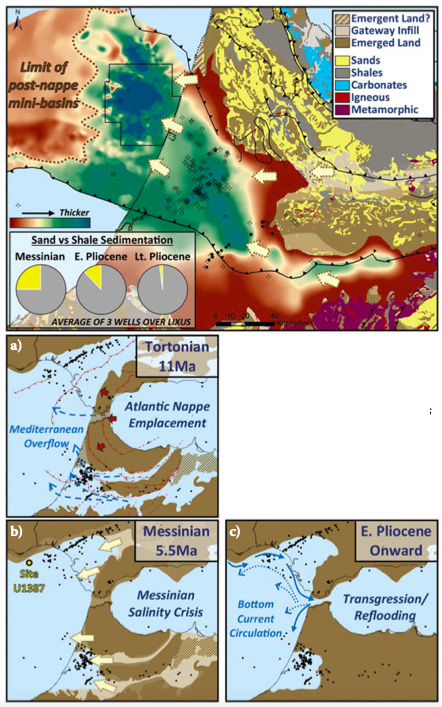
a–c: Maps showing Late Miocene to Pliocene paleogeographic evolution, modified after Capella et al. (2018).
Clastic source and reservoir distribution
The Alpine orogenic event led to the emplacement of the Pre-Rifaine Nappe, an allochthonous unit that reached the Atlantic in the Late Miocene (Figure 4). Well data suggests that emplacement was complete by the Late Tortonian (Figure 4a). During this period, the Atlantic–Mediterranean marine gateways, also referred to as the Betic and Rifian corridors, allowed throughflow of marine waters (Capella et al., 2018). Current direction through these gateways and the Straits of Gibraltar, which was also open at this time, was controlled by westward propagating tectonics.
Increased uplift rates across the Alpine belt and the resulting closure of these gateways caused a major increase in clastic sediment supply to the Atlantic basins in the Messinian (Figure 4b). This termination of ocean circulation triggered the Messinian Salinity Crisis in the Mediterranean and allowed Atlantic basins to access greater clastic sediment supply shedding off from the growing orogen.
When the Gibraltar Straits reopened in the Early Pliocene (Figure 4c), renewed circulation of Atlantic–Mediterranean bottom currents caused a gradual shift from sand-rich turbidite to mud-rich contourite deposition by the Late Pliocene. This depositional system is mirrored in the Gulf of Cadiz, as confirmed by research drilling at Site U1387. The distinctive Early Pliocene Unconformity marks this reflooding as a regionally extensive, erosional event.
The magnitude of sand supplied into the basin by the orogenic wedge during this tectonic evolution is supported by wells drilled on-block that penetrate the Upper Miocene–Pliocene (Figure 4, inset pie charts). Biostratigraphy data in these wells also confirm the deposition of turbidite systems in a distal, deepwater setting. Through mapping of regional data, it is evident that this area marks the terminal point of deposition into the basin.
Data analysis and prospectivity
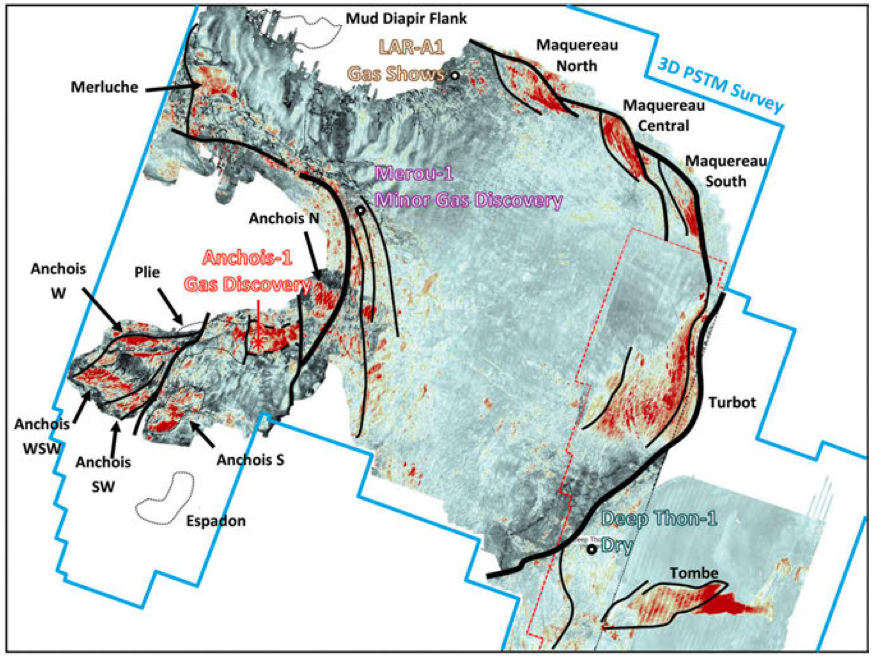
Correlation of seismic, well and outcrop data across the entire Rharb Basin clearly shows that the Lixus area is an extension of the proven onshore oil and gas producing basin. Larger resource potential exists offshore owing to a combination of the greater accommodation space and the distal setting, leading to the deposition of thicker and more aerially extensive reservoir bodies (Figure 5). Feeder systems that originate from the onshore supply mature clastics into lower slope to basin floor channel and fan deposits in the offshore domain. Channel systems can be seen clearly on spectral decomposition maps (Figure 6), where sands show a strong contrast against background shales on the frequency spectrum. Brightening on spectral decomposition not only aids mapping of sand fairways but also provides geophysical evidence of the presence of gas, as demonstrated at the Anchois discovery. Using spectral decomposition as a tool in facies identification and to map the distribution of reservoir systems has been very powerful compared to the use of conventional seismic amplitudes alone.
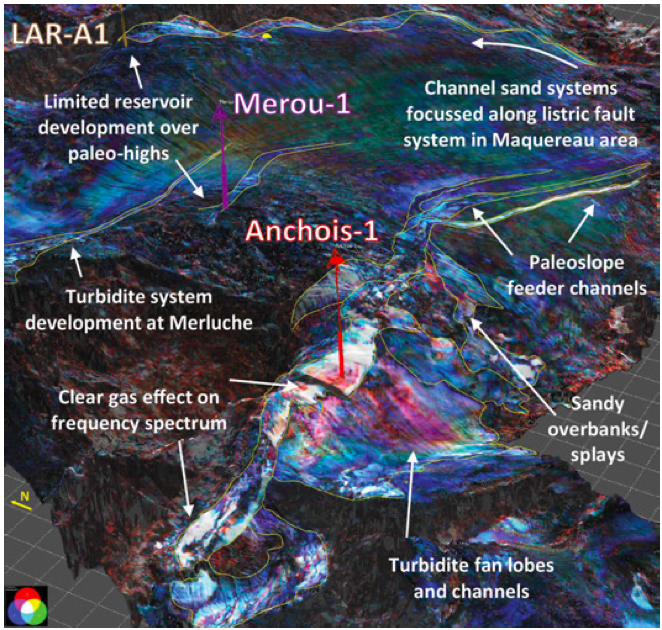
Restoration of depositional environments, achieved by combining these observations with isopach reconstructions, was also key to understanding how the sands entered the basin and were distributed within different mini-basins. For example, a basin entry point is interpreted at Turbot, with a sand-rich succession thickening against the easternmost basin-bounding growth fault of the Lixus mini-basin (see Figure 1). Extensions of this system can be tracked around the basin edge to the north, through the Maquereau prospects area, where thick sands have accumulated along this fault system as accommodation space has opened during deposition. Subsequent inversion due to reactive mud tectonics has created trapping geometries.
Petrophysical analysis of well data proved that the Miocene sands have excellent reservoir properties, with up to 30% porosity and >1 Darcy permeability. Well-to-seismic ties demonstrate that these gas-bearing sands, mapped as soft (trough) events, show increase in full-stack amplitude response and strong class III AVO anomaly on offset stacks. These properties, along with other qualitative attributes such as flat spots, velocity push-downs and low frequency wavelets, are found in mapped prospects, but absent in proven water-bearing sands. The well-seismic calibration of proven gas-bearing sands at the well location has proven invaluable in de-risking remaining basin prospectivity.
Recent PSDM reprocessing of the vintage dataset is further de-risking discovered and prospective resources within the proven Miocene gas play, as well as opening new play systems for gas in the Pliocene and for oil in the sub-nappe section through the significant improvements in deep imaging. With proven resources ready for commercialization and long-term growth opportunities through a diverse set of exploration plays, the high potential of this area is only just starting to be fully resolved.


