New seismic interpretation study uncovers the hydrocarbon potential of the underexplored Mid North Sea High
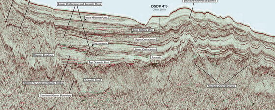
The 29th UK Licensing Round, launched by the UK Oil and Gas Authority (OGA) in July 2016, made significant acreage in the large and underexplored frontier area of the Mid North Sea High (Figure 1) available.
Government-funded 2D broadband seismic shot in 2015, together with reprocessed legacy data, were made available at the same time (Figure 2). This provided a dataset which can be used to better understand the hydrocarbon potential of the area.
In 2016, as part of the OGA’s Exploration Licence Competition (see OGA Launches Exploration Licence Competition), the Aberdeen-based consultancy Geop4ysics Ltd undertook a structural 2D seismic interpretation and rock physics study in the Mid-North Sea High (MNSH) area. This provided a seismic, structural and stratigraphic interpretation.
The study was undertaken over the course of seven months, which involved an initial feasibility phase prior to the final project.
Figure 2: Broadband and legacy seismic dataset for the Mid North Sea High used in the study, together with location of blocks identified in the text. (Source: Geop4ysics)
Challenges in the MNSH
Both regional tectonic setting and depositional character show noticeable contrasts in their geological development across the MNSH area. Devonian strata include marine limestones and continental deposits of the Old Red Sandstone. In the Carboniferous, sedimentation began with a shallow marine transgression and limestone deposition, followed by the Millstone Grit Formation, comprising delta front sandstones. Later in the Carboniferous, fluvial channels and swamps were developed, resulting in the deposition of rich organic material in the Westphalian Coal Measures.
The main tectonic phases – rifting at the end of Devonian, compression with inversion during the Carboniferous and extensive erosional episodes – were analysed using the seismic data described above. The Carboniferous sediments may have been heavily folded and faulted due to Variscan compression, which was followed by erosion at the base of the Permian (Base Permian Unconformity, or BPU) and then by the development of the Zechstein salt. Diapirs induced by halokinesis in the Zechstein salt are widely present in the MNSH area and lead to significant seismic imaging problems. Further tectonism during the Mesozoic influenced older pre-Permian deposits causing reactivation of faults, and this feature is critical to the understanding of hydrocarbon migration and trapping.
Competition Background
In 2016 the Oil and Gas Authority launched a £500,000 competition to encourage innovative interpretations of the data acquired during 2015’s surveys of the Rockall Basin and Mid North Sea High areas. We asked Kinga what motivated her team to take part in the Competition.
‘It was difficult to resist undertaking broadband inversion on the new acquired seismic data. I believed that acoustic impedance could improve lithofacies understanding and delineate possible reservoirs. During a feasibility study the challenges of well seismic tying, along with conventional and broadband wavelet extraction, were addressed and QC tests were performed to define inversion parameters.
In addition to understanding facies distributions, I have also been trying to solve the structural complexity of the MNSH and determine the main structural lineaments. This involved using 2 different software platforms (one for rock physics and the second for structural interpretation) and handling vast amounts of data during the short period of 2.5 months to deliver results.
As a direct result of the study, I will then be able to assist awarded companies in 29th Round in their further scope of work. Now, together with Ossian Consultancy, we will continue this research to provide a geophysical and geological assessment of the complex subsurface.’
Hydrocarbon Kitchen
The prolific Southern Gas Basin, lying to the south of the MNSH (see Figure 1 and Figure 2), was extensively explored in the past, with wells drilled to the Carboniferous providing evidence of a working petroleum system. The basin contains great thicknesses of Carboniferous sediments which were deposited during subsidence and include the Westphalian coal beds, a proven source of gas. This was expelled from the Westphalian coal beds at depth and high temperature, migrated into the sand prone units and was trapped at the base of the Permian over much of the area.
Reservoir and Trap Mechanism
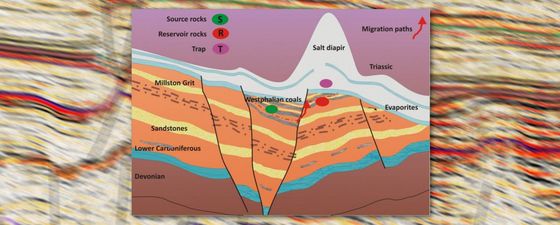
The main erosional event at the base of the Permian removed younger Westphalian sediments from the uplifted fault blocks and from the crest of anticlines. Figure 3 shows the trapping mechanism, illustrating Carboniferous sandstones which are truncated by the Base Zechstein (BPU). Sandstone reservoirs may be interbedded with shales, which provides an additional intra-formational sealing mechanism. Faults are possible conduits for the vertical migration for gas.
Figure 3: Example of a trap in Westphalian sandstones. Gas reservoirs are likely to be sourced by Westphalian coals, although older deposits might also be the source of hydrocarbons. Gas can be trapped in Carboniferous sandstones sealed by the base of the Permian or by intra-formational shales.
The discovery of the Breagh field situated in Block 42/13 (see Figure 2) on the northern edge of the Southern Gas Basin may be explained by a very similar trapping mechanism. Seismic profiles provide evidence of a clear closure at the base of the Zechstein which is interpreted as the upthrown side of the fault. This uplifted block was eroded and the reservoir sands were found to be fluvial channels of Lower Carboniferous age. The downthrown side of the fault may contain younger Westphalian sediments and they are probably the source rocks for the gas. Lower Carboniferous coal seams, encountered in well 42/13-4, may also be considered as a possible source of hydrocarbons.
Another example of a gas field situated in the Carboniferous Southern Basin in Block 44/12 is shown in Figure 4, where the thick Westphalian and Namurian age sediments can be seen to be truncated by the BPU.
Figure 4: Seismic profile over block 44/12 in the Carboniferous Southern Gas Basin. Coal Measures of Upper Carboniferous age comprising high porosity sandstones, coal seams and interbedded shales were eroded at the base of the Permian (BPU).
The Permian Rotliegendes is present in much of this area and may be represented by the claystones of the Silverpit Formation or by the prominent Leman Sandstone. Well 44/12-1 found gas in the Leman Sandstone and also in high porosity Westphalian sandstones. This well also encountered middle Carboniferous (Millstone Grit) tight sandstones with poor reservoir quality.
Devonian Reefs and Palaeozoic Platform
Carbonate build-ups which grew in situ or were transported to the shelf edge may show high porosities and are well known as an excellent trap for hydrocarbons when sealed by overlying impermeable shales.
In the more central part of the MNSH, much of the Upper Carboniferous appears to have been eroded during the Variscan orogeny. Devonian and Lower Carboniferous deposits overly the older Palaeozoic platform in block 37/12 (see Figure 2). It is evident that the structural setting in this area is very different from that of the Southern Gas Basin because the Westphalian deposits are absent. The source rocks therefore need to be found in the Lower Carboniferous or Devonian.
Below the Zechstein succession well 37/12-1 encountered only Devonian deposits with thin limestone beds, referred to as the Kyle Limestone. Some small organic build-ups were found, but with disappointingly low reservoir properties. Although hydrocarbons were not found in this well, facies analysis suggested a better depositional environment, favourable for growing reefs, is more likely to be found to the south. However, the next well drilled did not confirm the presence of either reefs or hydrocarbons. The situation in this area is shown in Figure 4 and is open for interpretation.
The seismic line shows evidence of strong reflectors which might be a thicker, faulted carbonate formation (however the presence of volcanic intrusions should not be excluded). Faults were interpreted as extending up to Base Zechstein level, while other faults might be syn-depositional, terminating at the end of carbonate deposition. The seismic is unfortunately contaminated by residual multiples and there is also the possibility of apparent anomalous reflectors, such as sideswipes. Hence, improved seismic processing is crucial for the understanding of seismic reflectors at pre-Permian level and to aid the interpretation of unconformities.
Figure 5: The older Palaeozoic platform is overlain by a strong reflector encountered in the well as thin beds of limestone. The whole Palaeozoic block is faulted. However, a bright package of reflectors is visible at the outer edge of the platform and may represent thicker limestone, possibly organic reef.
Why Choose Stratigraphic Interpretation?
Some wells which were drilled on structural highs in Quadrants 37 – 39 of the MNSH encountered uplifted blocks of Devonian Old Red Sandstone. Hydrocarbons were absent in these wells, but we can observe the erosional character of the BPU and pinch-out of reflectors on seismic, which provide evidence that stratigraphic traps are possible in the area. The combination of structural and stratigraphic interpretation provides more opportunities to unravel the potential of new plays in underexplored areas of the MNSH. Improved seismic imaging and using attributes allows for better definition of angular unconformities, enhanced understanding of depositional character and improved fault interpretation.
External link
OGA Competition winners