
Newly acquired, high quality 3D date accelerates exploration insight in the Zechstein Play
The Zechstein play in the UK sector is increasingly in the industry spotlight after the 2019 Ossian-Darach well discovery and with Shell preparing to drill the Pensacola prospect later this year. The known imaging challenges in this area combined with the operational complexities of a tidally complex, shared-use environment required a range of technologies and methods to ensure the delivery of a 11,000 km², high quality seismic image within the timeframe to influence critical decisions as this play gains momentum.
The ION MNSH Prime 3D™ multi-client program of the greater Mid North Sea High is a primary acquisition campaign off the UK continental shelf that commenced in 2020 with the Phase 1 survey. Phases 2 and 3 were acquired concurrently in 2021, presenting numerous operational challenges given the proximity of the areas.
The presence of ION personnel and software onboard the two survey vessels ensured both operations were planned and managed effectively. The specialists on each vessel coordinated acquisition to ensure the seismic vessels maintained a minimum distance of 12 km between active sources to comply with Joint Nature Conservation Committee (JNCC) environmental requirements whilst also ensuring no downtime was incurred by either survey.
As these surveys were a continuation of the program started in 2020, lessons learnt from Phase 1 were carried forward to the 2021 acquisition with the two principal strategies implemented infield: tidal racetrack and tidal matching multi-swath matching.
The multi-swath technique seeks to reduce the elective infill by subdividing each swath and matching lines with similar feather direction and magnitude. As monthly feather amplitude changes, acquisition moves between sub-swaths to achieve an optimal feather match. This aims to reduce elective infill and replaces this with ‘progressive’ infill at sub-swath boundaries which are fewer in number and straighter to steer.
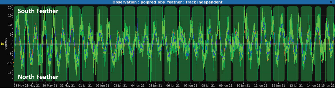
The surveys were broken down into three discrete areas to maximise potential efficiencies presented by the geometry. The line lengths in the north section were favourable for a straightforward two-swath tidal racetrack acquisition method. This allowed each line to be acquired at the same phase of the semidiurnal tidal cycle as the adjacent line, resulting in minimal feather mismatch and reduced requirement for infill (Figure 2).
In the central area, a four-swath tidal matching strategy was employed. Each full line required an average of 24.5 hours to complete with a nominal line change time of 3.3 hours. This timing allowed the completion of four sail-line passes over nine full rotations of the semidiurnal tidal cycle with each line in tidal phase with the adjacent pass.
A multi-swath acquisition method was also considered for the southern sections. However, as the Phase 2 survey is in a heavily congested area, line selection was focused on working around extensive simultaneous operations. This included extensive fishing activity, a 2D regional survey, numerous site surveys and sub-sea construction.
To minimise the impact of these ongoing operations on acquisition, ION’s Marlin™ software was installed on both vessels and received live AIS positions of all vessels in the area. This ensured that the ION specialists had a complete view of all vessels in the area to plan acquisition around the operations while maintaining tidal synchronisation where possible with the adjacent line.
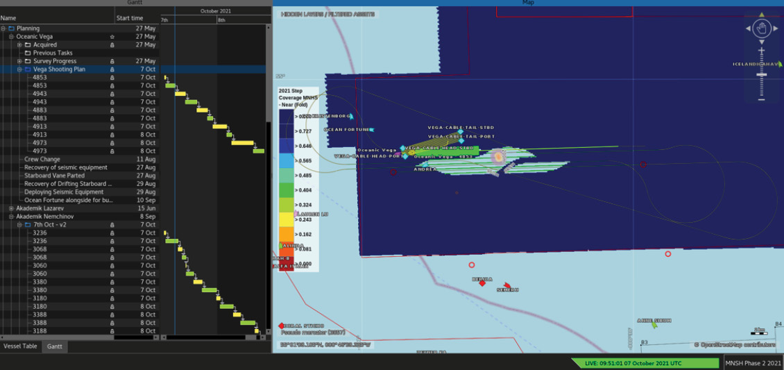
ION’s connected software was utilised to provide onshore personnel with near real-time survey progress and QC updates, providing valuable insights into the operations for informed decision-making (Figure 3).
Overcoming imaging challenges
The ION Imaging and Reservoir Services team uses a full range of up-to-date processing and imaging methods for the MNSH Prime 3D program.
Due to the triple source used in acquisition, the flow begins with deblending and an inversion-based approach. Denoise and deghost follow the deblending, prior to demultiple.
North Sea surveys are associated with shallow-water challenges and this project was no exception with some of the shallowest bathymetry in the Southern North Sea being found within the MNSH Prime 3D survey area. There was a demultiple challenge to overcome with the fast chalk outcropping in the western seabed combined with the shallow water depth across the entire survey. Careful modelling and subtraction of the multiple using wave equation and model-based technologies attack the short period water layer multiples, while muted surface related multiple elimination addresses the longer period multiples and interbed multiple elimination techniques remove internal bounces associated with specific horizons. Following demultiple, the data is regularised prior to migration.
Creating a velocity model to image over 10,000 km² whilst accounting for changes in the geological units and the structures requires attention to detail and experience. The challenges are addressed with a combination of machine learning first break full waveform inversion (FWI), guided move-out tomography, interpretation and reflection FWI. Within the areas, eight wells are used for velocity QC and mis-tie analysis. Products for Phases 2 and 3 include TTI Kirchhoff (90 Hz) and reverse time migration (40 Hz) stacks to merge seamlessly with the available Phase 1 data, offering 12,000 km² of high quality data (Figure 1B).
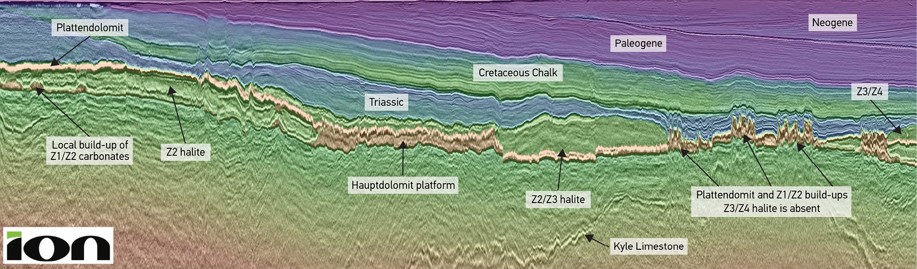
Interpreting variations in the Zechstein Play

The imaging of Phase 2 builds on knowledge developed from Phase 1, revealing the expansive Zechstein Hauptdolomit platform area across the Mid North Sea High. The main platform can be mapped across the survey, stepping down towards the south (Figure 4). The platform is predicted to extend to the north and east outside the current 3D survey. There is a clear contrast between the extensive platform in the east and the slope to the basinal area in the west (Figure 1B). The platform is characterised by thick, high-velocity layers of (Z1/Z2) anhydrite and dolomite with halite lenses overlying the Hauptdolomit; these are linked to in-filling of structural depressions in the base Zechstein by sea water. In the west, there is an increased amount of halite and polyhalite present below the Plattendolomit while the Hauptdolomit is represented by a series of promontories which are postulated to be relatively isolated build-ups above Carboniferous highs (e.g., the Ossian-Darach and Pensacola prospects).
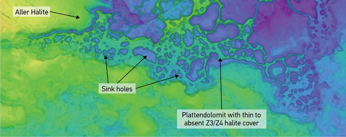
In the east of Phase 2, there is a distinct zone where the upper Zechstein halite units are thin or absent and Triassic strata downlap directly onto the Plattendolomit. This zone is coincident with a Devonian high, potentially leaving this area emergent during the deposition of Z3/Z4 halite units (Figure 5). The upper Zechstein is also thin to absent in the shallow section to the west where the Zechstein is thinner overall as accommodation space was reduced. In the platformal areas, the Plattendolomit is characterised by the presence of sink holes formed through dissolution of underlying evaporate units and collapse.


