Exploring the deeper potential of the Central North Sea
With recent successes, such as the Glengorm and Isabella discoveries, the Central North Sea is proving that the deeper potential may hold the key to future exploration.
The complex geology of the Central North Sea (CNS) has historically proven to be a challenge for the seismic imaging of deeper targets in the basin. These challenges include the relatively shallow water (<100m), complex Tertiary and Quaternary deposits with shallow channels, contourites and shallow gas anomalies, a thick and hard layer of Cretaceous chalk and complex deep tectono-stratigraphic evolution related to Mesozoic rifting and halokinesis of the Permian Zechstein salt. These, combined with a thick overburden within the basin axis that leads to high-pressure, high-temperature (HP/HT) reservoir conditions, have meant that the targeting of deeper plays in the area has historically been high-risk. Fortunately, recent advances in seismic imaging technologies, including improvements in depth imaging and migration techniques, are providing new insights to reduce the risks associated with these plays.
An ‘evolution’ in seismic imaging
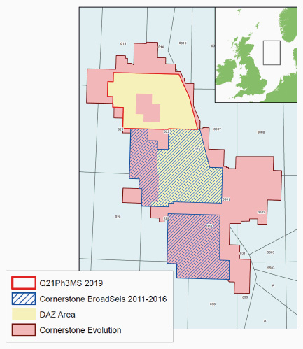
CGG recently undertook a two-year, ground-up, reprocessing project of its entire Cornerstone data set in the CNS. The new Cornerstone Evolution data consists of over 50,000 km2 of 3D long-offset seismic data acquired over the past three decades, across 10 quadrants of the UK and Norwegian Central North Sea, from UKCS Quadrant 38 in the south to UKCS Quadrant 15 in the north (see foldout map). The final Evolution data comprises a series of surveys acquired with conventional flat-tow acquisition in a north-south orientation. It also includes the data from CGG’s first multi-sensor streamer survey in the region, using Sercel’s Sentinel® MS technology, and its BroadSeisTM, variable-depth steamer broadband data, acquired in a west–east azimuth to provide over 18,000 km2 of dual-azimuth (DAZ) data coverage in the region.
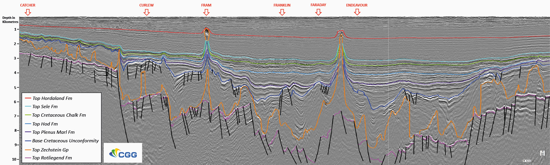
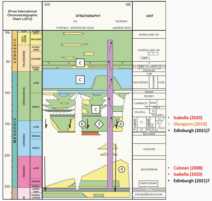
The main objective of the Evolution reprocessing project was to improve the illumination and depth positioning of deeper targets (Figure 1), increasing the signal-to-noise ratio, whilst ensuring the amplitude-versus- offset (AVO) fidelity of the data. To achieve this, the data was reprocessed from its original raw state (i.e., field tapes) and the latest imaging technologies were applied, including enhanced joint source and receiver deghosting and fully data-driven model-based shallow water demultiple and short-period multiple suppression algorithms. To achieve the most reliable velocity model to date for accurate depth imaging, it was calibrated to 10 regional structural horizons and more than 200 wells. The key horizons incorporated into the depth model building included: Top Sele Formation, Top Cretaceous Chalk, Top Cromer Knoll Group, Base Cretaceous Unconformity, Top Salt and Base Zechstein; some of which are indicated on the foldout image.
Furthermore, with advances in computation power and algorithm efficiency, Q-FWI (Full Waveform Inversion) was run across all input data, inverting for both absorption (Q) and velocity for high-resolution modelling of the overburden. In addition, CGG’s proprietary Time-Lag FWI which incorporates reflections and refractions was also run for deeper velocity updates within the complex Cretaceous chalk layer. The velocity modelling sequence incorporated salt scenario testing with targeted Reverse-Time Migrations (RTM) for 24 piercing salt diapirs within the region. This, combined with a velocity model constructed in both the north–south and east–west azimuths, resulted in the most advanced regional velocity model constructed in the area to date, to achieve reliable depth imaging of the deeper structural targets (Figure 1).
Exploring deeper
In the last 10 years of exploration in the CNS, 124 exploration wells have been drilled in UK and Norwegian waters. Of these, over 50% have targeted the deep Jurassic and Triassic plays with varying success. Yet, recent successes targeting these plays have increased focus on the deeper potential of the basin (Figure 2). The first of these successes was the Culzean discovery in 2008 by Maersk, when well 22/25a-9 encountered hydrocarbons within Middle Jurassic Pentland Formation and Triassic Skagerrak Formation sandstones. This was followed by several smaller discoveries prior to the discovery of Glengorm in 2018 in Quadrant 22. Drilled by well 22/21c-13, it encountered hydrocarbons in high quality Upper Jurassic reservoirs. More recently, however, the Isabella discovery has further increased focus on the deeper potential. Drilled by Neptune with the 30/12d-11 well in early 2020, the well encountered 64m of net pay, again within Upper Jurassic and Triassic sandstone reservoirs. This exploration trend looks set to continue with the planned drilling of the high-impact ‘Edinburgh’ well, by Shell and its partners in 2021. The reservoir target, similar to Isabella, is within a tilted-fault block adjacent to a Permian salt diapir and likely contains Jurassic and Triassic reservoir intervals.
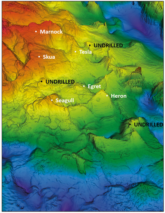
A clearer view
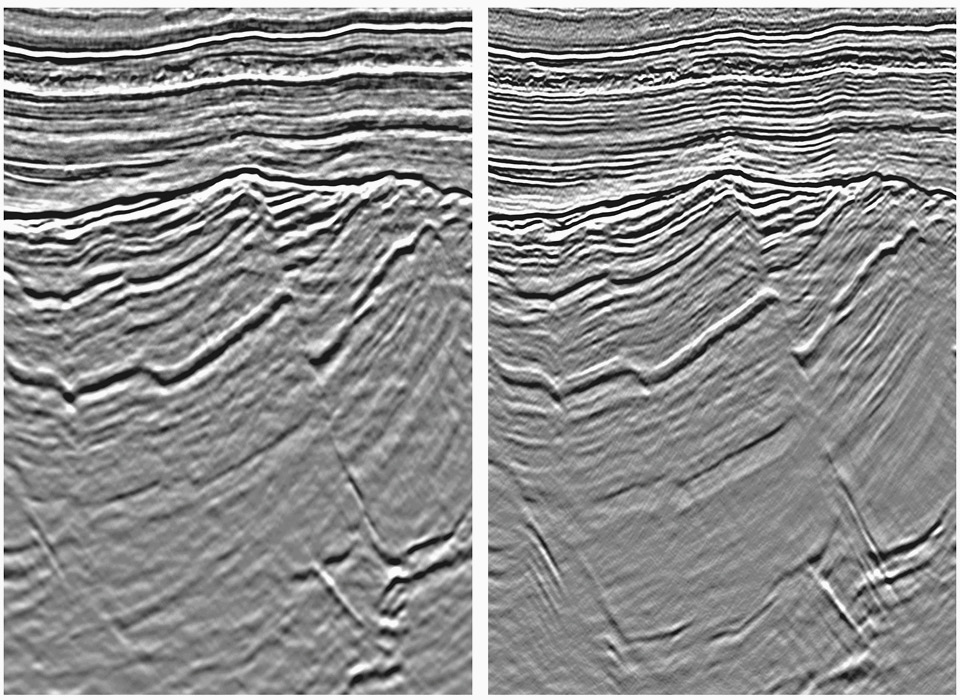
Reservoir presence and effectiveness are critical risk components when targeting the deeper HP/HT plays of the Central Graben. High quality seismic data is therefore essential to de-risk these plays. With Cornerstone Evolution, particular attention has been paid to the deeper imaging. Historically, the presence of peg-leg, inter-bed and water-bottom multiples has adversely affected the imaging below the Base Cretaceous Unconformity (BCU), where structural targets are comprised of highly faulted and rotated fault blocks. The use of advanced multiple-suppression algorithms, such as 3D SRME, MWD and Wave-Equation deconvolution, has dramatically improved the signal at depth. This, combined with Least-Squares Kirchhoff migration, which has further enhanced the deeper image by reducing the high-frequency random noise, is helping to identify new deep potential with the identification of a number of undrilled structural targets based on the new data (Figure 3).