T&T: A closer look at oil and gas exploration prospects
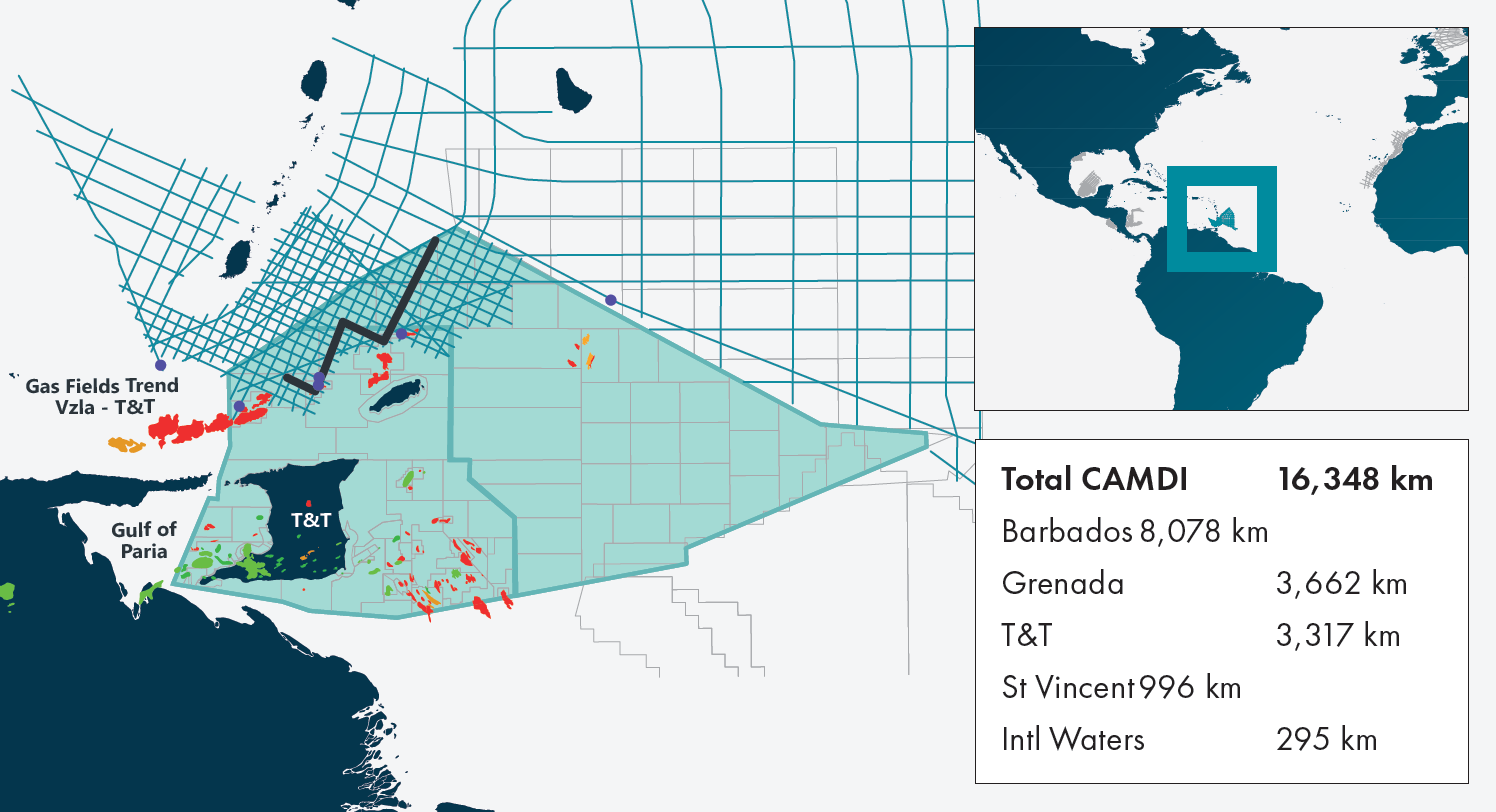
The Caribbean Atlantic Margin Deep Imaging seismic survey (CAMDI) spans 16,348 km, with long offsets (12 km) and a deep record length (18 seconds). This transnational survey covers acreage across the maritime borders of Barbados, Trinidad & Tobago (T&T), Grenada, and St. Vincent.
The survey was originally designed in two grids. The regional grid provides a better understanding of the tectonic framework of the different basins along the Southeastern Caribbean and Western Atlantic Margin of Northeast South America. The detailed grid, offshore Trinidad & Tobago, and Grenada is designed to provide more localized detail, and to outline potential prospects. Seismic within the detailed grid ties the producing areas of T&T to the underexplored deeper part of the Tobago Trough. Approximately 3315 km of the CAMDI survey are located offshore Trinidad & Tobago, covering shallow and deep-water blocks.
Geological proximity to producing fields
The CAMDI MC2D survey is situated in close proximity to the producing areas of the Orinoco Delta and Northern T&T. The tectonic history of the region has afforded a preferential setting for hydrocarbon accumulations.
Tectonics offshore T&T were significantly influenced by the North/South American tectonic plates and their interaction with the Caribbean plate. During the Late Jurassic to Early Cretaceous, significant rifting occurred between North and South America. Following this rifting, the Caribbean plate migrated eastward from the Late Cretaceous onwards, relative to the North and South American plates to its present-day position.

During this migration and throughout the Cenozoic, the Caribbean plate converged obliquely with the North and South American plates in a diachronous manner. The points of collision shifted from westernmost Colombia during the Santonian era to western and central Venezuela in the Paleogene & eastern Venezuela in the Neogene. Present day convergence is believed to be between the Paria Peninsula of Venezuela and the Northern Trinidad Range. The Atlantic lithosphere has been subducting beneath the Lesser Antilles throughout these epochs and into the present day. The collision between these plate boundaries created a range of geodynamic processes including subduction, transpression and transtension, creating a large accretionary ridge which contributes to the regional geology.
The Tobago Trough is a curved-shaped forearc basin with a sedimentary fill of approximately 11-14 km of Oligo- Miocene to Pleistocene sediment. It is bounded by the Lesser Antilles arc to the west, the Barbados accretionary prism to the east, and the St Lucia Ridge to the north. To the east the Tobago Trough transitions to the Carupano basin offshore eastern Venezuela. The origin and age of the Tobago Trough basement is unknown. However, radiometric and paleontological ages from outcrops found in Tobago seem to indicate a Late Cretaceous forearc origin. This is supported by basement ages from Oil & Gas exploration wells in the Carupano basin. The complex structural setting, geometries and subsidence mechanisms of the basins located in this area are controlled by several fault systems, that were the result of major tectonic events in the southeastern Caribbean.

Direct connection to world class source rock (equivalent to La Luna)
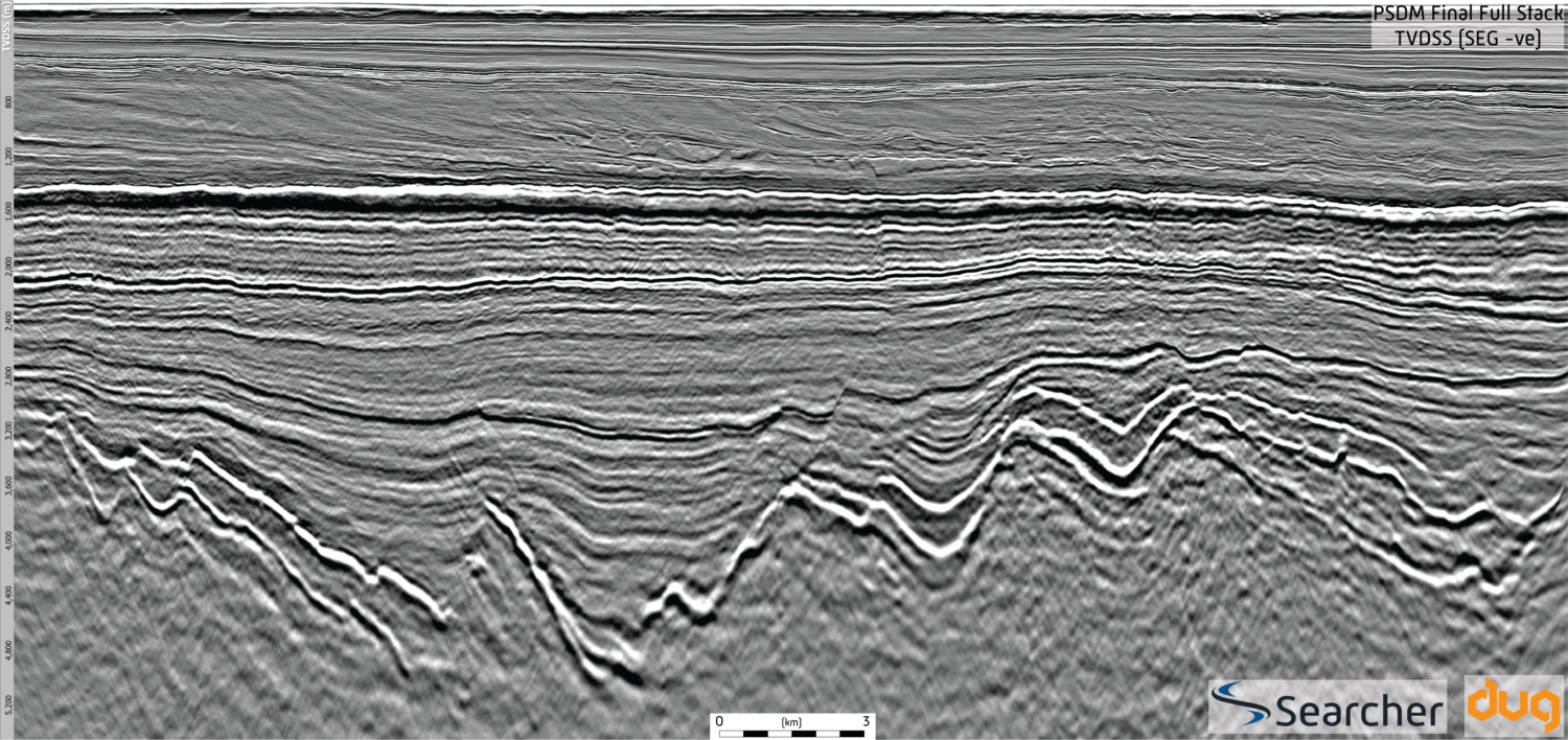
Distal DSDP and ODP wells offshore Venezuela and Barbados have shown evidence of a regional Upper Cretaceous source rock equivalent to the La Luna Formation of Venezuela. Maturation is predicted to have started during the Miocene in the Eastern Venezuelan Basin and during the late Miocene-Recent offshore Trinidad. Onshore Barbados, the Woodbourne oilfield produces oil and gas from the Eocene Scotland Group, sourced from a La Luna age equivalent source rock. This oil play remains unproven as there are no well penetrations in the Tobago trough. However, the CAMDI MC2D survey reveals a distinctive regional high amplitude horizon that could represent the Top Cretaceous Mejillones Complex (Figure 1).
Structural trapping plays a major role
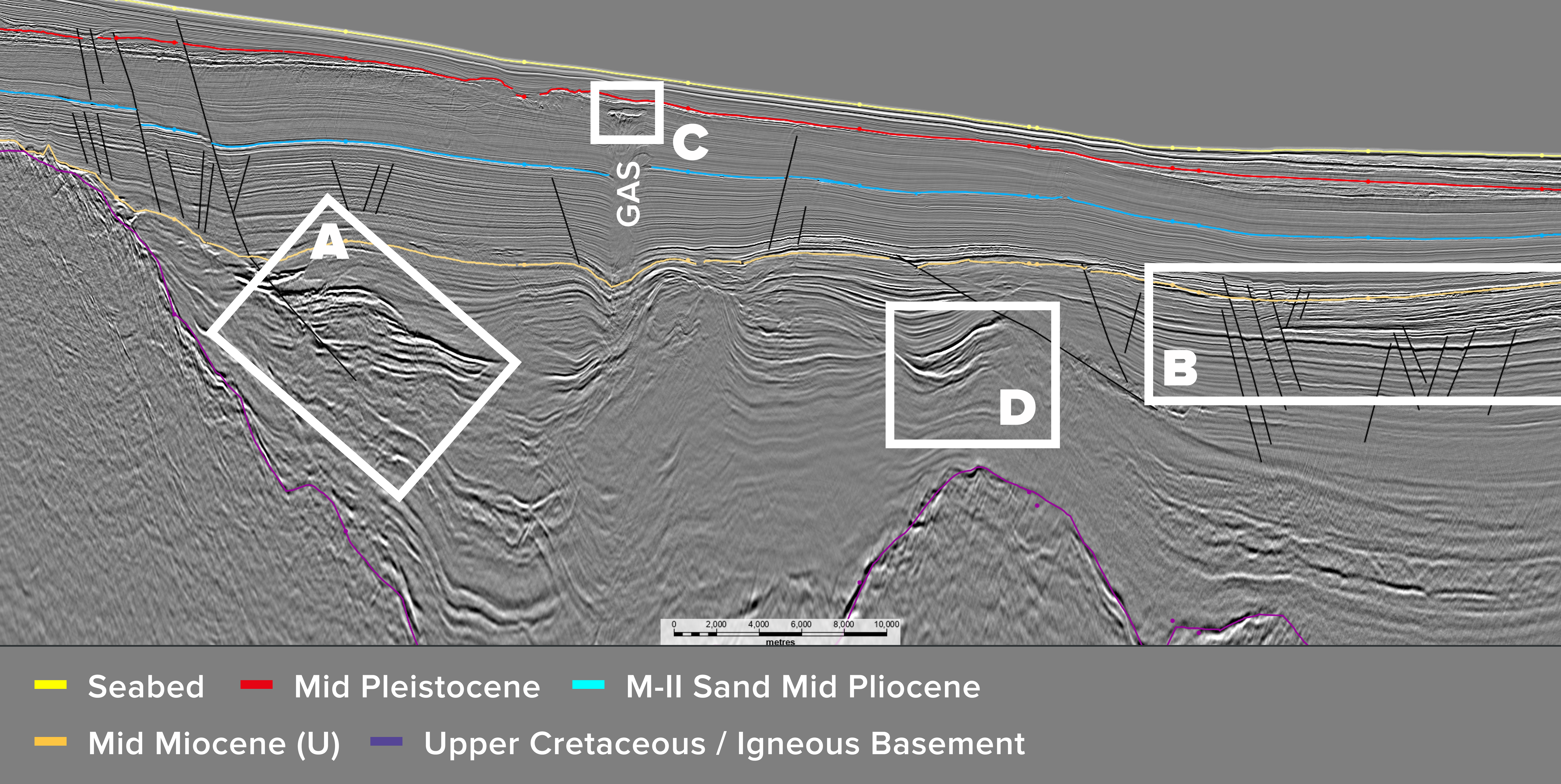
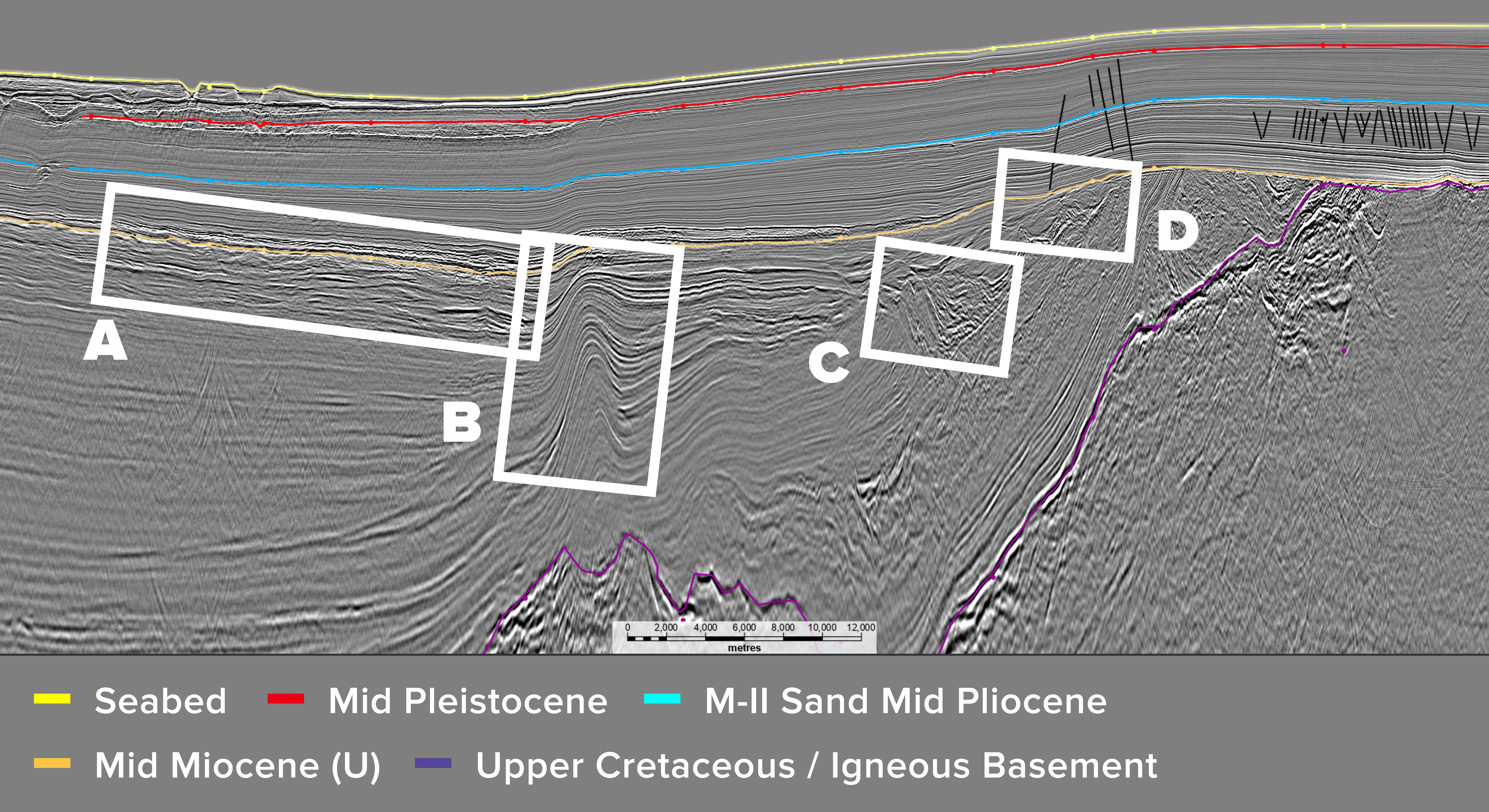
The area covered by the CAMDI survey is significantly underexplored. However, several biogenic gas fields (Hibiscus, Sancoche, Orchid, etc.) have been discovered in close proximity. The producing intervals are Miocene and Pliocene aged turbiditic and deltaic sands, which were deposited during the progressive easterly progradation of the Orinoco Delta. Structural trapping plays a major role within the study area as reservoirs are often trapped against faulted structures and turbidites. While most target intervals and discoveries are situated in Pliocene intervals, Mid Miocene and Eocene sands are also possible reservoirs. Sands in the basin are predominantly turbiditic and channelized features. Above these sands, there is a highly contrasting interval representing a good seal for the system. Example leads include (Figures 2 and 3):
- Mid Miocene and older Turbidite Deposits
- Mid Miocene Channels exhibiting DHI’s (Amplitude anomalies)
- Four-way closures exhibiting DHI’s
- Three-way closures against a fault exhibiting DHI’s
- Truncational play against the Ridge

All the necessary hydrocarbon elements for a working petroleum system are present in the region. Gas production from nearby fields offshore T&T, along with the onshore Barbados Woodbourne oil field production provide evidence for commercial hydrocarbon potential in the region. The CAMDI MC2D survey shows a regional distribution of multiple, structural traps and potentially high-quality sheet turbidite reservoirs. Overlying hemipelagic marine clays would form the sealing facies with migration into the reservoirs (Miocene – Eocene) occurring along a combination of thrust and transtension strike slip faults associated with the deformation front. The presence of a La Luna age equivalent source rock suggests a potential oil play within the Tobago Trough, with further reservoir-seal pairs provided by the Plio–Pleistocene deep marine pelagic sediments.
A unique frontier opportunity
The Tobago Trough is an underexplored area flanked by oil and gas production in Barbados, T&T and a new gas discovery offshore Grenada. Seismic interpretation shows a thick sedimentary succession with high hydrocarbon potential. A Cretaceous, La Luna age equivalent, oil prone source rock is believed to have been identified, charging prospects in the area. The CAMDI survey offers the most modern PSTM, PSDM, gravity and magnetic data in the region, ideally positioned to support the upcoming license bid rounds in Trinidad & Tobago.
References
Aitken T., P. Mann, a. Escalona, G. Christeson (2011) Evolution of the Grenada and Tobago Basins and implications for arc migration, Mar. Pet. Geol., 28(1), 237-260.
Escalona, A., and P. Mann (2011), Tectonics, basin subsidence mechanisms, and paleogeography of the Caribbean-South American plate boundary zone, Mar. Pet. Geol., 28(1), 8–39.
Exploration Consultants Limited. (2004) Evaluation of Exploration and Production Opportunities in Trinidad and Tobago.
Frost, C.D., A.W. Snoke, (1989) Tobago, West Indies, a fragment of a Mesozoic oceanic island arc: Petrochemical evidence. Journal of the Geological Society of London 146, 953–964.
Masi, J. “Seismic imaging of the Upper Mantle structure and dynamics beneath the Southern Caribbean plate boundary and Venezuela.” (2013) Diss., Rice University. Houston 145 pp .
Osman, A., Steel, R.j., Ramsook, r., Olariu, C., and Chen S. (2020) The Arrival of the paleo-Orinoco Delta at Trinidad: The Cruse Formation delta lobes and delivery to deepwater Atlantic. Journal of Sedimentary Research, 90(8), 938-968.
Ysaccis, R. (1997) Tertiary evolution of the northeastern Venezuela offshore. Ph.D. thesis, Rice University, Houston, 1997. 285 pp.


