Although the UK North Sea is becoming increasingly mature as an exploration province, the search for hydrocarbons continues, albeit with new focuses. One of these in recent years has been the Triassic play. Statistics show that the Triassic is one of a few under-explored plays that is able to deliver substantial resources with a high commercial chance of success (Figures 1 and 2). Westwood Global highlight that the Triassic commercial success rate is 40% with an average discovery size of 95 MMboe (Figure 1). When we look at the number of exploration wells in the last 8 years (Figure 1) and the creaming curves broken down by plays (Figure 2) we see that the Triassic is very under-explored. So although not a frequent target for exploration, Triassic prospects are generally low risk and high reward.
This article highlights how the use of new data and best practice techniques can help companies unearth opportunities and value. While new seismic helps define traps previously too deep to be well imaged, it is the integration of this data with a regional basinwide understanding of the Triassic geology which provides detailed insight into reservoir quality, one of the key risks in the play. The big picture informs the local detail!
Triassic Stratigraphy
Triassic deposition is interpreted to have occurred in a dryland fluvialacustrine setting (McKie & Audretsch, 2005; McKie 2014; Cope, 1992). The overall depositional setting for the Lower Triassic was one of relatively arid conditions, with ephemeral terminal fluvial systems discharging into desiccated and evaporitic playas as terminal splay systems. In contrast, facies associations in the Middle to Upper Triassic suggest a dry land depositional system which was typically wetter than in the Lower Triassic, allowing the formation of well developed river courses which sourced perennial lakes and marshes (McKie, 2014). Fluvial channel facies are typically fine to medium grained and characterised by a low clay content, while lake margin terminal splay facies are finer grained, and more argillaceous and micaceous (Akbokodje et al., 2017). These depositional textures retain a primary control on porosity evolution through burial. Consequently, well-sorted, clean, fluvial sandstones provide the most important Triassic reservoir targets in the North Sea.
The Triassic stratigraphy of the South Viking Graben is poorly understood compared to the Central Graben, owing to fewer well penetrations in the axial parts of the basin. Along the basin’s Norwegian eastern margin, detailed chemostratigraphic, sedimentological and petrographic analysis means we are able to update our understanding of age and facies and integrate this with recent seismic interpretation. This has important implications on our understanding of the expected reservoir quality of these units and may, in part, explain the poor reservoir properties observed in at least some of the Triassic wells along the flanks of the South Viking Graben. Despite the greater depth of burial in the basin axis, better reservoirs can be expected in these more basinal locations, where we would expect a high dominance of fluvial channels throughout the Triassic.
New Eyes, Improved Clarity
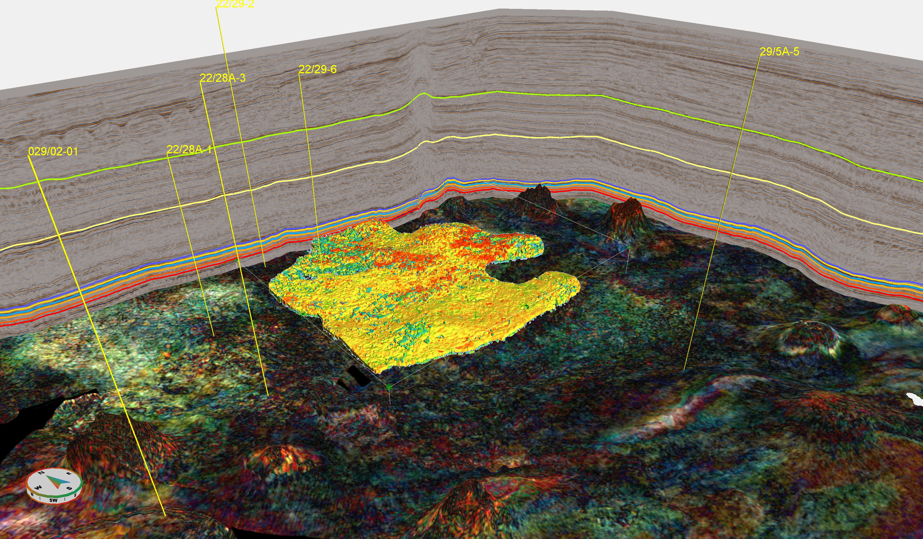
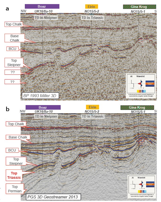
In addition to new insights into the depositional settings and facies types, new broadband seismic data provide much better imaging of the deep trapping mechanisms. Figure 2a shows the large, untested Boaz tilted fault block prospect on vintage data. Well 16/8a-10, drilled in 1988, reached total depth in the overlying Middle Jurassic Sleipner but did not reach the Triassic sands. In the adjacent blocks to the east in Norway lies the Eirin field, which flows gas condensate from the Triassic. In the vintage seismic, it is difficult to interpret below the Sleipner coals, which is why the industry has historically struggled to gain confidence in defining the Boaz trap. With new broadband seismic data (Figure 2b), there is far greater clarity at depth, and we can now correlate new prospects to known discoveries – Boaz to Eirin and to surrounding wells. We now have the ability to not only map the top of the Triassic directly but also to define important intra-Triassic reflectors and deeper stratigraphy, such as the Permian.
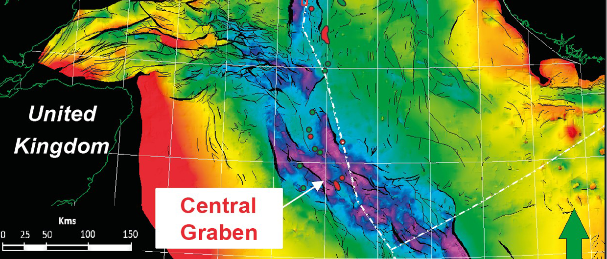
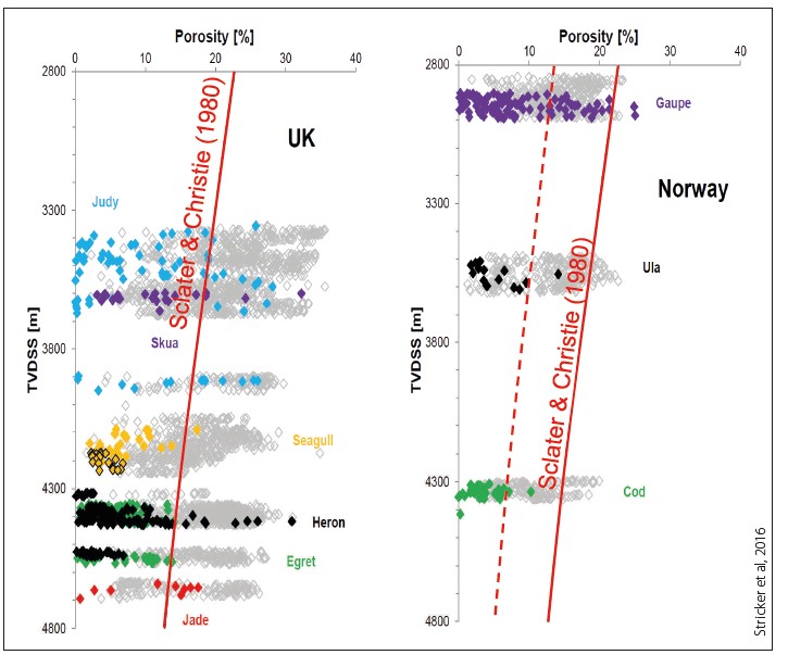
The next challenge is reservoir quality. Big Data, such as regional 3D seismic, allows for a detailed understanding of the basin history and architecture. This is fundamental to making the correct analogues when comparing new basins with better-known critical wells and fields within the same play. The closest Triassic fields to the South Viking Graben are those on the Sleipner Terrace in Norway (Figure 1). Slater et al. (2016) show that if you take Norwegian core data from the Sleipner Terrace (Figure 3, right), and project to depths of known structures (~4,500m) within the South Viking Graben, sandstone porosities will be degraded and provide only poor conduits to fluid flow. The dotted line represents the mean porosity, indicating porosities of below 10% at a depth of 4,500m. However, if you take the UK trend (Figure 3, left), predominantly driven by wells in the Central Graben, the indication is that porosities and therefore permeabilities will provide good quality reservoirs that can flow hydrocarbons. Porosities on this trend average 15–20% for depths around 4,500m, and could be expected to have a reasonable permeability.
Further to the primary facies control, reservoir quality is controlled by opposing subsurface processes that can either degrade the reservoir or act to preserve porosity. To understand the rock properties, we need to understand the regional forces acting on them. Degradation is caused by two main controls: mechanical compaction (controlled by vertical effective stress) and chemical compaction (pressure solution and quartz cementation, primarily temperature controlled). Preservation is assisted by three key controls inhibiting quartz cementation: presence of clay grain coatings, early migration of hydrocarbons and overpressure. Understanding the rates and timing of all these controls is the key to forward predicting new areas of effective reservoir quality.
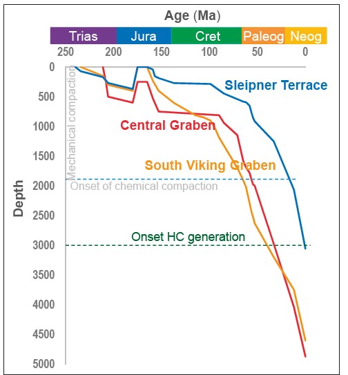
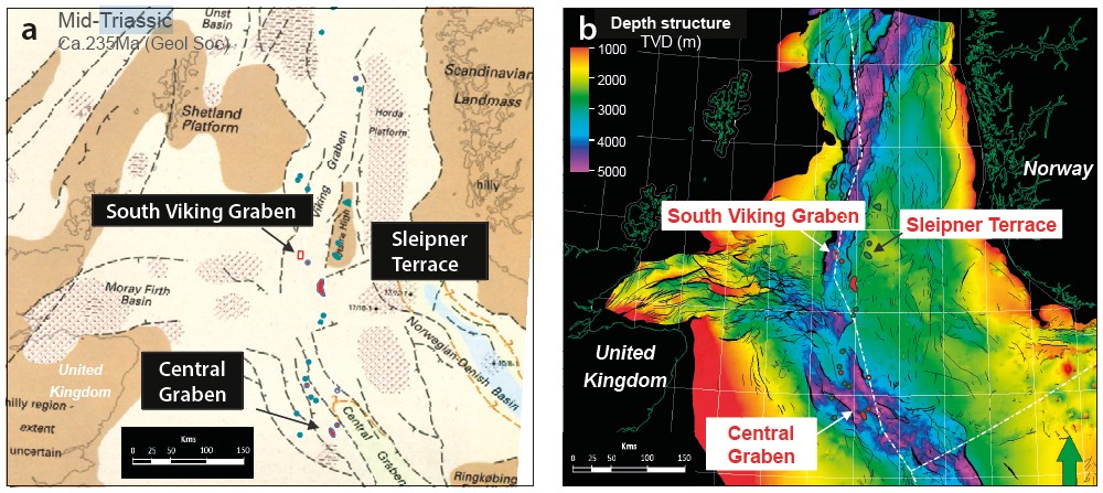
By comparing burial history models for the South Viking Graben to the better-known Sleipner Terrace and Central Graben, we see that the South Viking Graben undergoes rapid burial from the Upper Jurassic period, unlike the Central Graben and Sleipner Terrace (Figure 4). Rapid burial creates overpressured reservoir bodies and causes earlier entry into the hydrocarbon generation window than in the other two areas. Both of these physical processes Will assist in preserving porosities and permeabilities.
In addition to high sedimentation rates in post-Triassic times, the low thermal gradient in the South Viking Graben, along with regional gravity maps, indicate that it was a longstanding depocentre prior to the Triassic. The net effect of this is that, while the rocks may have been buried quickly, they have been exposed to lower temperatures than other rocks at equivalent depths in the Central Graben, for example. This has positive connotations for reservoir preservation.
It also illustrates that the South Viking Graben is more analogous to the Central Graben than to the Sleipner Terrace area, and in the Central Graben reservoir quality is known to be good at a considerable depth. The regional basin modelling and loading of the South Viking Graben rocks mean that the physical processes acting upon this area would allow for preservation of adequate reservoir qualities, unlike those indicated from the trends identified from the Norwegian Sleipner Terrace; the Sleipner Terrace area is an inappropriate dataset for guiding trends within the Viking Graben.
Quantitative Predictions
Observations from the Triassic show that from a rock physics viewpoint it is actually very well behaved, and sands are almost always softer, i.e. lower acoustic impedance (AI), than the encasing shales. This is due to the sandstone structure maintaining a relative consistent framework, while the shales through time have undergone a larger degree of change.
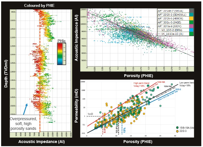
This is shown in Figure 5: highly porous sands are soft (low AI) while tight low porosity shales and silts are hard (high AI). When a formation behaves in this way it is incredibly useful – the seismic can be inverted to acoustic impedance, and from this we can get an indication of porosity and then permeability through rock physics transforms built around the data and relationships presented.
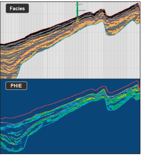
Rock physics models and transforms give us the ability to convert seismic reflection data and seismic velocities into petrophysical properties (facies, porosity and permeability), as shown in Figure 6.
Bridging Basins
By driving for Big Data and detailed understanding, the industry can support pushing plays beyond previously recognised conventional boundaries, extending them into new sub-basins. Big regional datasets and high-powered computing allow us to build large regional maps and isochores crossing several basins, letting us bridge basins and draw on more distal analogues. New data and integrated studies provide clarity and new insight into the subsurface.
We can clearly see the benefits of using the data to extend the Triassic play from the more conventional Central Graben area north into the Viking Graben and possibly beyond. The Triassic section, in particular, shows very few anomalous rock properties and this can, and should, be taken advantage of in both exploration and production predictions.