To see the full seismic lines please download our PDF for the print issue available through this link: GEO ExPro Vol. 10 No. 3
New insights with broadband data
New seismic acquisition and processing techniques can be used to shed new light on a very mature basin like the UK North Sea.
Recent advances in seismic acquisition and processing technology such as broadband seismic help the geologist to understand the subsurface structure and properties in greater detail. Using its curved variable-depth streamer solution, BroadSeisTM, CGG recently acquired a new broadband survey in the UK North Sea West Central Graben (WCG) area with several objectives in mind:
- Provide high-resolution imaging of the shallow subsurface to help identify potential drilling hazards and better constrain the Pleistocene channels geometry;
- Resolve in greater detail the Lower Tertiary geology, especially the Tay Formation which represents a major exploration target in the area;
- Improve the understanding of the Chalk facies and fluid distribution, knowing that several discoveries and prospects have been identified over the West Central Graben Margin;
- Help with the geological interpretation of deep targets below the Base Cretaceous Unconformity aided by the deeper penetration of the low seismic frequencies.
Geo-hazards and the shallow subsurface
The western part of the Central North Sea is known to have numerous channels near the seabed inducing sharp velocity contrasts in the shallow section, which can create unwanted pull-downs on the seismic data. If these velocity contrasts are not accurately accounted for, these channels can have a detrimental effect on the interpretation of structures in the depth domain and exploration companies may potentially leave behind some missed pay intervals.
This new broadband dataset provides high-resolution imaging of the near-surface to tackle this problem in the West Central Graben. There are also benefits for drilling hazards identification, reducing the uncertainty on the location of potential shallow gas caps.
Mapping the Tay sands
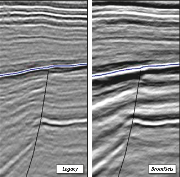
A number of producing fields are found within the Tay sands in the WCG area where these reservoir sands can show porosities of up to 35% with high net-to-gross and high permeabilities. The Guillemot and Gannet field clusters have been producing from this reservoir for about two decades. The Guillemot field is characterised by a high-amplitude seismic anomaly highlighting the presence of hydrocarbons within the Tay reservoir sands, which is made more evident by the low-frequency component of the broader bandwidth of the seismic data. Typically, the top of the Tay Formation is defined by a bright continuous reflector on seismic data, marking a sharp transition from clay-dominated Eocene sediments to clean turbidite sands.
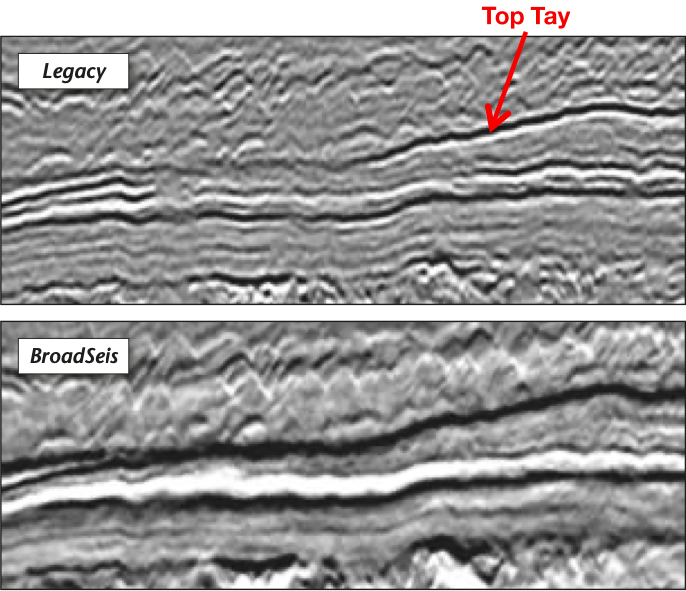
Looking at seismic data from an interpreter’s point of view, the benefits brought by broadband seismic are twofold. First, the introduction of lower frequencies into the signal reduces the side-lobes of the zero-phased wavelet which interferes with the picking of a specific reflector. This is illustrated in the figure below, where we can see that conventional, band-limited data display a prominent side-lobe (i.e. the white halo appearing above and below the Top Tay reflector) around the actual Top Tay reflector.
Secondly, the introduction of higher frequencies sharpens the central peak of the wavelet, pushing the tuning limits further and increasing the resolution of top and base of thin beds and subtle structures. This image also shows the presence of a dim zone on the conventional data through the central part of the section which affects the Top Tay reflector, which is not the case on the BroadSeis data. This demonstrates that broadband seismic brings additional, useful information from outside the conventional seismic bandwidth to better image the Tay sands, hence supporting the identification of potential new traps in the West Central Graben.
Chalk facies in the West Central Graben
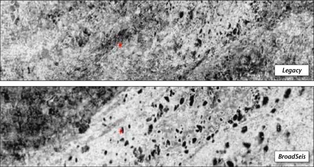
Back in 1993, well 21/25-12 discovered oil in the Ekofisk and Tor formations. An amplitude anomaly is visible at that level in the seismic section shown on the fold-out on the previous page. This was never developed, but then, in 2012, the Orchid discovery was made within UKCS Block 29/1c. This is now pending development, bringing the interest in Upper Cretaceous Chalk plays in the WCG area to the next level. The amplitude anomaly is also clearly visible on the seismic data and is probably due to a combined porosity and oil saturation response. In the light of these discoveries, it is easy to understand that mapping facies variations within the Chalk is of paramount importance in the search for new prospects, especially knowing that the upper Chalk section is affected by various diagenetic events, re-working of the sediments and carbonate dissolution.
The figure below illustrates the improvements brought by broadband seismic in mapping these facies. With an identical RMS amplitude extraction method, we can see that conventional seismic data struggles to define dissolution features within the upper Chalk interval, whereas they are very well delineated with broadband data (i.e. black features on the map). Also, the lower frequencies highlight a regional facies trend: marlier, softer chalk in darker grey shades, while the white and lighter grey shades indicate the presence of carbonate-rich, hard chalk.
Deep Jurassic interpretation
A number of fields have been discovered in the Jurassic Fulmar sands in the WCG area: Christian, Cook, Teal, Bligh and Selkirk to name a few. As low frequencies penetrate deeper into the earth, the broadband seismic data helps the imaging of these deep targets in the West Central Graben. These low frequencies also give more character to the seismic data, which provide useful information to correlate deep Fulmar sands across adjacent fault blocks (see figure above). In addition, knowing that a number of those deep fields in the WCG area are considered high-pressure/high-temperature, the extra low-frequency content of broadband seismic data can potentially be used to determine pressure gradients more accurately from seismic velocities.
A powerful technology
Located in an established producing area of the Central North Sea, this BroadSeis survey recently acquired in the UK West Central Graben demonstrates the huge value of the broadband curved variable-depth streamer solution. The exploration industry is now using these enhanced seismic data to unveil the remaining potential of the area. Further broadband seismic datasets are being acquired across the Central North Sea, which will no doubt shed new light on our geological understanding of an already very mature basin.
Images courtesy of CGG Data Library.