
The geography of continents and oceans has changed through geologic time. The supercontinent cycle describes the assembly, duration and fragmentation of the largest landmasses on Earth as a result of large-scale, long-term plate tectonic processes originating within the mantle and the crust. While its causes and patterns are little understood, the supercontinent cycle has first-order impacts on sea levels, climate, ecology, evolution, and mineral resources.

Alfred Wegener’s map of Pangaea and a modern reconstruction. Source: Wikipedia Commons.
Continents and Oceans
There are, depending on how you count, five or seven continents and five to seven oceans in the world. For the geographer, continents and oceans are respectively the largest landmasses and water bodies in the world. For the geologist, they also represent different types of crustal rocks. Continents are mainly made of quartz-rich (typically granitic) rocks with a density of 2.7 g/cm3. They include the emergent lands as well as adjacent continental shelves under water depths of 200 metres or so. Oceanic crust is mainly made of denser basalt (2.9 g/cm3). That is why oceanic curst easily subducts beneath continental plates, while continental crust, once formed, may last for billions of years.
Continental margins are important not only for land–ocean interactions but also for mineral resources. In passive continental margins, both the continent and adjacent ocean are parts of the same tectonic plate, while in active continental margins, the ocean floor is a separate plate subducting beneath the continent, and producing a volcanic arc with active seismicity.
Suess, Wegener, and the Path to Pangaea
The jigsaw fit of coastlines on opposite sides of the Atlantic Ocean drew the attention of several scientists as far back as the 16th century. It appeared that South America and Africa were once together but were later torn away. In the 19th century, geologists believed that as the Earth cooled and shrank, the crust underwent collapse. Therefore, land bridges for example between South America and Africa sank and gave way to the South Atlantic Ocean. Based on this thinking (‘contractionism‘) and using similarities in rock formations and fossils on continents currently far apart, the Austrian geologist Eduard Suess in his influential book Das Antliz der Erde (Face of the Earth, 1904) postulated the existence of at least three supercontinents in the geologic past: Gondwanaland (comprised of India, Africa, Australia, South America, and Antarctica, and named after the Gond tribes of central India), Laurentia (North America and Europe, and named after the Laurentian mountains in Canada), and Angaraland (East Siberia and parts of China, named after the Angara river). Nevertheless, Suess still believed that the present continents were always where they are now (‘permanentism’ or ‘fixism‘).

Histogram of detrital zircon ages determined by U-Pb indicating crystallisation ages of rocks from various parts of the world (compiled by Peter Voice et al., Journal of Geology, 2011) coinciding with ages of widespread mountain-building events (orogenies) suggested by Keith Runcorn.
By the 1910s, three findings discredited both contractionism and permanentism. First was the discovery of radioactive elements in rocks, which implied the Earth’s crust was actually heated by radioactive decay. Second was the principle of isostasy, suggesting that the Earth’s crust was floating on a denser and mobile layer. Third was the observation that the oceanic crust was not made of continental rocks but of basalt. The German scientist Alfred Wegener embraced these findings and expanded on Suess’s geologic comparisons of continents; but unlike Suess, he concluded that continents had drifted apart. He envisioned that during the Permian all the continents were united as a supercontinent he called Pangaea (‘all earth‘) surrounded by the Panthalasa (‘all ocean‘). Pangaea consisted of Gondwana in the southern hemisphere and Laurasia (combined Laurentia and Angara) in the north. Wegener published his ideas in his 1915 book Die Entstehung der Kontinente und Ozeane (The Origin of Continents and Oceans, 1924). Wegener had all the evidence for continental drift but could not explain what forces could enable it.
Although rejected by the majority of geologists in the first half of 20th century, the discovery of seafloor spreading and subduction zones in the 1950s–60s validated Wegener’s idea in the form of plate tectonics. Today, we can even measure the movements of tectonic plates from remote sensing and GPS technologies.
Pulse of Earth
Plate tectonics is a continuous process although not at constant rates. Is global tectonics random, or is there some order and cyclicity in its operation? Several geologists reflected on these questions even before the birth of plate tectonic theory. The culmination of these thoughts was a 1942 book, Pulse of the Earth, by the Dutch geologist Jan Umbgrove, who compiled various data on tectonic, magmatic and sedimentary records for the Phanerozoic Eon worldwide, and suggested that there were two ‘pulses’ of widespread tectonic activities. This line of thinking was taken up by Thomas Worsley of Ohio University at Athens and his colleagues R. Damian Nance and Judith Moody (his wife) in the 1980s. They argued that tectonic and magmatic activities, as well as climatic shifts, sea-level changes, biogeochemical signatures, and biological evolution observed during specific intervals are related to the assembly, duration or breakup of supercontinents, and that Pangaea was the last of a series of supercontinents Earth has witnessed. Based on clustering of radiometric ages, Worsley and colleagues identified five supercontinents at 250 million years, 650 million years, 1,100 million years, 1,600–1,800 million years, 2,100 million years, and 2,600 million years ago, consistent with similar geochronologic patterns recognised by Gordon Gastil, Keith Runcorn, and John Sutton in the early 1960s. Other geologists such as Kent C. Condie and John J.W. Rogers have also contributed to tectonic episodicity and formation of supercontinents.

Reconstructions of Rodinia at 1 billion years ago as originally suggested by Mark and Diana McMenamin in their book The Emergence of Animals: The Cambrian Breakthrough (Cambridge University Press, 1990), and a recent reconstruction by John Goodge (Wikipedia Commons, 2011). © Rasoul Sorkhabi.
Supercontinents Before Pangaea
To identify supercontinents, geologists correlate the ages and facies of rock formations, tectonic deformation, and sedimentary and fossil records across the continents. Collisional mountain belts (and their structural and metamorphic signatures) and geologic parallelism between the Precambrian ’shields‘ or ‘cratons’ (continental cores) provide particular clues to the former supercontinents. Today’s geologists are also equipped with radiometric dating, geochemical analyses, and paleomagnetism which gives paleopositions of rock samples (if remained undisturbed or corrected for tectonic tilting).
The Permian–Triassic Pangaea underwent fragmentation in the Jurassic, thus opening the present Atlantic, Indian and Antarctic oceans. Pangaea, being the most recent supercontinent, is well documented. As we go back in time, our knowledge of the size, configuration, and timing of supercontinents diminishes because the geologic records are destroyed by tectonic and erosional processes. For 4.5–3.0 billion years of Earth’s history, the term ‘supercontinent’ may even lose its meaning, and we perhaps better use the term continental block or blocks.
In 1976, Andrew Button identified Kaapvaal craton in southern Africa and Pilbara craton in Western Australia as remnants of an Archean continent; he called it Vaalbara (Kaapvaal + Pilbara). John Rogers extended this continent to include several cratons in southern India and Madagascar; he called it Ur (after the world’s oldest city in Mesopotamia), dating back to 3.1 billion years ago. This seems to be the oldest continental block we know of. Next came Kenorland (named after the Kenoran orogeny) at 2.8–2.2 billion years ago, which included the core of North America, Greenland, Baltica (north-west Europe), and also possibly extending to Ur.
Rogers also envisioned the formation of Arctica (cratons of North America, Greenland, and Siberia) at 2.5 billion years ago and Atlantica (consisting of West Africa and South America across the present Atlantic) at 2.0 billion years ago.

Reconstruction of Columbia originally suggested by Rogers and Santosh (Gondwana Research, v. 5, 2002) and a recent reconstruction (Alexandre DeZotti, Wikipedia Commons, 2016).
For the period 2.1–1.7 billion years ago, there is evidence for a supercontinent, initially called Nena (after North Europe and North America) or Nuna (an Eskimo word for ’lands bordering the northern oceans‘). Paul Hoffman, who gave the name Nuna, included Laurentia, Baltica, and Angara (Siberia). John Rogers extended it to an all-inclusive supercontinent called Columbia (from the geologic records in the Columbian river area of western North America). Columbia fragmented during 1.7–1.4 billion years ago. Continental fragments came together again at 1.2–1.0 billion years ago to form Rodinia, so named by Mark and Diana McMenamin after the Russian word rodit, meaning ’to give birth’, on the assumption that this supercontinent gave birth to all subsequent continents. Rodinia broke up from 750–600 million years ago.
During 600–500 million years ago, Greater Gondwana or Pannotia (‘all southern lands’) in the southern hemisphere formed. It merged with Laurasia to create Pangaea at 300–250 million years ago (the Permian period). Pangaea was the largest supercontinent ever.
John D.A. Piper has given the names Neo-pangaea (250 million years ago), Paleo-pangaea (1,000 million years ago), and Proto-pangaea (2,500 million years ago) to the supercontinents Pangaea, Rodinia and Columbia, respectively. This 800 million period is divided into three phases of assembly, stability, and breakup, each lasting 200–300 million years.
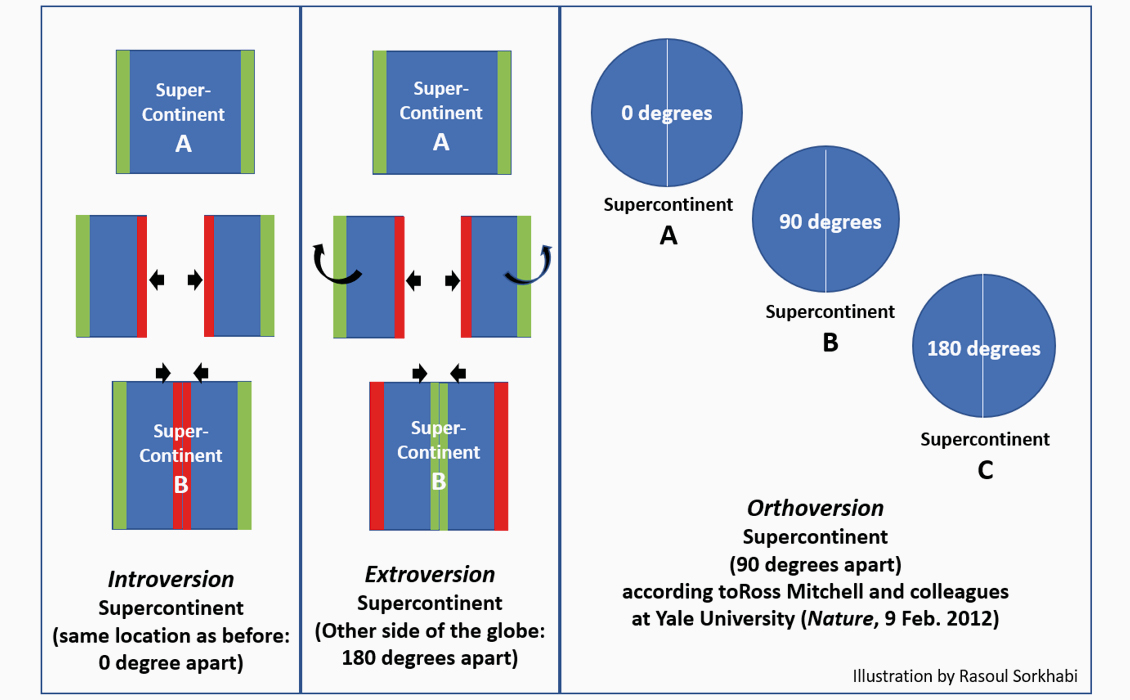
Three modes of assembly of a supercontinent. © Rasoul Sorkhabi.
Causes and Patterns
Supercontinent cyclicity is related to several major puzzles in tectonics including the growth of continental crust through the geologic time and the birth of plate tectonics. Earth’s oldest rocks (Acasta Gneiss of the Slave craton in Canada) are dated as 4.0 billion years old, and the oldest minerals (detrital zircons from Australia) are 4.2–4.4 billion years old. Tectonists like Kent Condie believe that plate tectonics on Earth was operational by at least 3 billion years ago. Prior to plate tectonics, Earth’s earliest lithosphere was possibly a single stagnant plate (‘lid tectonics’) as we also observe on the Moon, Mercury, Venus, and Mars. Geologists have also debated whether the continental crust grew progressively though the eons, or the bulk of Earth’s crust formed in the Hadean Eon – the first 500 million of Earth’s history.
Is a supercontinent cycle periodic? For tectonic episodicity, Umbgrove considered a 250 million-year cycle for the Phanerozoic, and Worsley and his colleagues suggested a 440 million-year cyclicity. However, a regular periodicity is not necessary for a cyclic process, especially given that Earth’s heat budget from both internal and radioactive sources has decreased through time. The driving forces for supercontinent cycles lie within the mantle, related to the physical heterogonies, evolution and large-scale circulations in the mantle. However, we do not have a clear understanding about these hidden mechanisms. Worsley and colleagues postulated that the assembly of a supercontinent is facilitated by the subduction of dense and cold basaltic oceanic crust beneath continents (slab pull), thus closing the oceanic basins; while the long stability of a supercontinent, because of its thickness and radiogenic heat, leads to accumulation of heat beneath the continental lithosphere as the granite-rich crust is less conductive and more insulative of heat. This thermal contrast causes ‘epeirogenic upwarp’ or thermal doming of the supercontinent that may eventually lead to its extension and rifting. Relating these ideas to the deep mantle processes, it seems that ‘avalanches’ of subducting slabs from the upper to the lowermost mantle, the so-called ‘slab grave yard’ at the core-mantle boundary, facilitates the assembly of supercontinents. In contrast, the rise of hot mantle plumes, especially superplumes from the ‘large low velocity provinces’ in core-mantle boundary, leads to the supercontinent breakup.
The assembly of supercontinents may take place according to a geographic pattern: Introversion (same location, 0 degree), Extroversion (the opposite side of the globe, 180 degrees), or Orthoversion (90 degrees from the previous location).
Consequence and Impacts
The assembly, duration, and fragmentation of supercontinents have first-order impacts on sea-level changes, climate, biogeochemical cycle of key elements, evolution of life, formation of minerals, and so forth. Here we look at their impacts on petroleum resources.
Works by T. Worsley, R.D. Nance, and J.B. Murphy show that with an elevated supercontinent (epeirogenic uplift), global sea level falls; during the supercontinent breakup with young oceanic crust, the sea level rises; and as the continental drift matures into old ocean basins the sea level falls again. Supercontinent breakups and ocean-floor spreading are associated with intense volcanic activities, which emit large quantities of carbon dioxide into the atmosphere and warm the climate via greenhouse effects. The plankton, which live in the upper 200 metres of the oceans and seas (the photic zone), source the bulk of hydrocarbon resources worldwide. Therefore, periods of high sea levels and warm climates flourish the plankton populations and expand their geographic area coverage. The Jurassic–Cretaceous ‘hothouse’, which accounts for more than two-thirds of petroleum reserves, is the best example of this phenomenon.
The assembly of a supercontinent is associated with continental collisions and increased rates of chemical weathering and erosion which remove carbon dioxide from the atmosphere and cause climate cooling. If the supercontinent is situated close to the pole, as happened in the case of the Permian Gondwana, it leads to a glacial age.
The vast majority of oil and gas fields are found in rift basins and passive continental margins (Atlantictype margins) during the supercontinent breakup, while active subduction margins (Pacific-type margins) have not been proven to be favourable sites for oil and gas fields.
Future Supercontinents
By projecting the present direction and rates of plate motions, geologists have postulated future supercontinents. Such projections for the next 50 million years or so may be reasonable, but beyond that, they are highly speculative as plates may undergo different deformation trajectories. In 1982, Christopher Scotese envisioned Pangaea Ultima (later called Pangaea Proxima, ‘Next Pangaea’) that will form 250 million years in the future. Paul Hoffman in 1992 suggested Amasia that will bring Asia and North America together as the intervening Pacific completely subducts. In the late 1990s Roy Livermore suggested Novapangaea (‘New Pangaea’). In 2016, João Duarte and colleagues at the University of Lisbon published a more circular tight configuration called Aurica, with Australia joining the Americas, Africa, and Antarctica close to the equator.

Four possible scenarios for the next supercontinent, 250 million years in the future. © Hannah S. Davis, Lisbon University.
As the Earth’s interior is gradually losing heat, plate tectonics will eventually stop. When that happens in an estimated two billion years’ time, our planet will possibly end up again with lid tectonics. In the meantime, we have more immediate problems to worry about.
For more information:
- Nance, R.D. and Murphy, J.B. 2014. The supercontinent cycle: a retrospective essay. Gondwana Research, v. 25, pp. 4–29.
- Nance, R.D., Worsley, T.R. and Moody, J.B. 1988. The supercontinent cycle. Scientific American, July 1988, pp. 72–79.
- Nield, T. 2009. Supercontinent: Ten Billion Years in the Life of Our Planet. Harvard University Press.
- Rogers, J.J.W. 1996. A history of continents in the past three billion years. Journal of Geology, v. 104, pp. 91–107.
- Rogers, J.J.W. and Santosh, M. 2004. Continents and Supercontinents. Oxford University Press.
Further Reading
The Wilson Cycle and Petroleum Plays
Rasoul Sorkhabi, Ph.D.
The Wilson Cycle describes the opening and closing of oceanic basins as a result of plate movements. It provides a scientific framework to follow the creation, development and destruction of sedimentary basins and how these processes impact on petroleum plays.
This article appeared in Vol. 17, No. 6 – 2020


