The Western Barents Sea from an Atlantic Margin Prospective
Cretaceous and Paleocene reservoirs have been proven in clastic turbidites in the Western Barents Sea. Oil- and gas-prone source rocks are expected to be widespread in the Cretaceous, as observed in other sectors of the Atlantic Margin in Norway and UK.
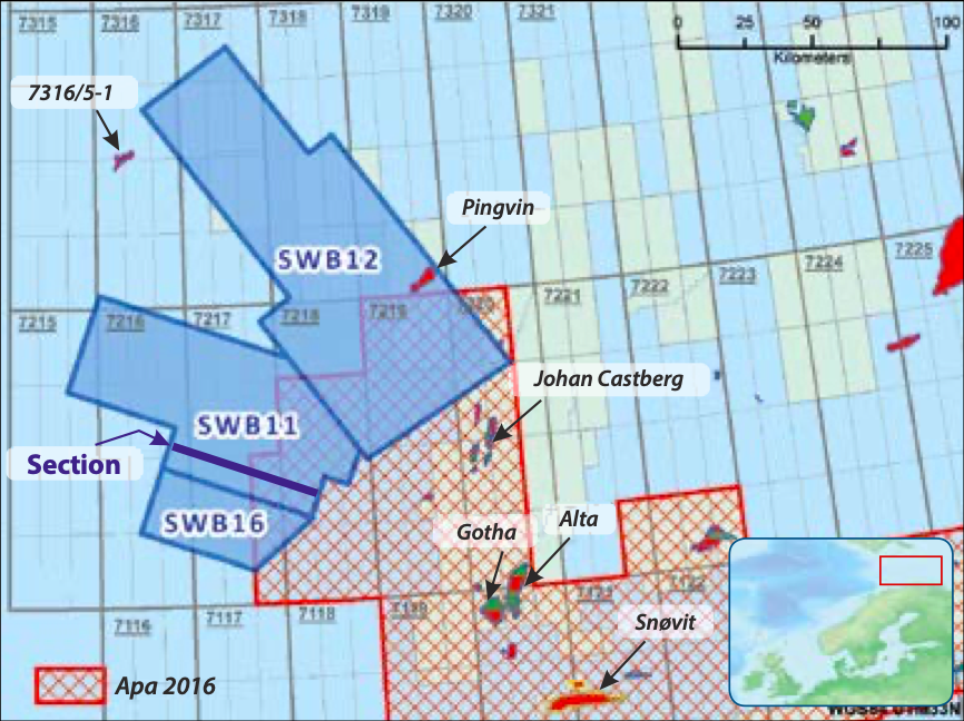
The Western Barents Sea has seen the highest rate of exploration success in all the Norwegian Barents Sea; it also includes active production facilities (Snøvit field) and future plans for development (Johan Castberg field). Successful hydrocarbon exploration in the Barents Sea relies on several hydrocarbons plays, laterally stacked in different basins (Figure 1), and vertically distributed in a variety of reservoirs. Triassic-Jurassic sands are historical targets for oil and gas; however, the recent discoveries of Gotha and Neiden have proved good reservoir properties even in Permian-Carboniferous carbonates. The westernmost margin is currently considered a new venture area, where gas sands have been already found from the Cretaceous to the Paleogene.
Between Arctic and Atlantic Plays
The Barents Sea is a well-established hydrocarbon province in the circum-Arctic region. Its prospectivity relies on the structural and paleogeographic evolution of the region from the Paleozoic through to the TriassicJurassic, which created the shallow continental platform of the Norwegian Barents Sea. Source rock deposition was widespread from the Paleozoic to the Jurassic, starting maturation and expulsion during the Triassic and the Jurassic. Tectonics remained relatively quiescent, with the formation of few structures, mostly related to halokinesis in PermianCarboniferous evaporites, as seen in the Nordkapp and Maud Basins. Cretaceous subsidence did not make a significant contribution within the main continental platform, being followed by erosion and uplift during the Paleogene and Neogene, with neo-formation of regional tectonic structures and consequent re-migration of the hydrocarbons already in place.
The opening of the North Atlantic margin enhanced the hydrocarbon habitat in the Western Barents Sea, rejuvenating the tectonic subsidence and allowing Triassic-Jurassic source rocks to generate oil and gas. The extensional tectonics reactivated previous faults from the Paleozoic in the Loppa High and Hammerfest, creating several basins. PAOLO ESESTIME, Spectrum Geo Cretaceous and Paleocene reservoirs have been proven in clastic turbidites in the Western Barents Sea. Oil- and gas-prone source rocks are expected to be widespread in the Cretaceous, as observed in other sectors of the Atlantic Margin in Norway and UK. Some discoveries, including Gotha and Neiden, are preserved in Permian-Triassic structures, while the majority of the fields and discoveries are sited on tilted fault blocks from the Jurassic and Cretaceous.
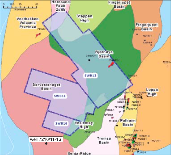
The tensile tectonics of the Atlantic rift migrated westward and northward from the Upper CretaceousPaleogene, and also combined with volcanism and oceanic spreading during the Neogene. The Tromsø, Bjornøya and Sørvestsnaget Basins have developed since the Lower Cretaceous, separated by structural highs which were subsequently reactivated. Tectonic extension remained active during the Upper Cretaceous to Paleocene, leading to the subsidence of the Sørvestsnaget Basin and its southern sector and creating accommodation space for the deposition of 3,000- 4,000m of clastic sequences and thick sand turbidites.
Risk Reduction in Cretaceous-Paleogene Plays
The revaluation of the regional prospectivity will reduce the exploration risk in Cretaceous-Paleogene targets, for both oil and gas in the western Barents Sea.
Source rocks: Understanding fault chronology is an excellent approach to reduce the risk related to the distribution of Lower Cretaceous source rocks. Good sources have been recognized in other sectors of the Norwegian Atlantic Margin, and in the Vøring Basin. Atlantic rifting resulted in a connected system of basins that extends north to the Lofoten Basin, so Lower Cretaceous source rocks are likely to be present up to the Tromsø and Sørvestsnaget Basins. In addition, future exploration may prove potential source rocks in Upper Cretaceous shales.
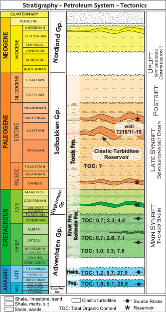
Thermal maturity: Jurassic source rocks can be considered oil and gas prone along the western margin of the Loppa High and the Bjornøya Basin. To the south, these units have been deeply buried since the Upper Cretaceous, generating almost exclusively gas. Lower Cretaceous source rocks show lower values of TOC than the Jurassic sources, and are around 3,000m thick, much larger than the tens of meters that characterize the Jurassic (Figure 2). The additional 2,000–3,000m of Upper Cretaceous-Paleogene may have even triggered the generation of oil and gas in Cretaceous source rocks. The Neogene section is almost entirely represented by glacial deposits of the Upper Pliocene sequence, which pushed the oil and gas windows up to the Paleogene sequence.
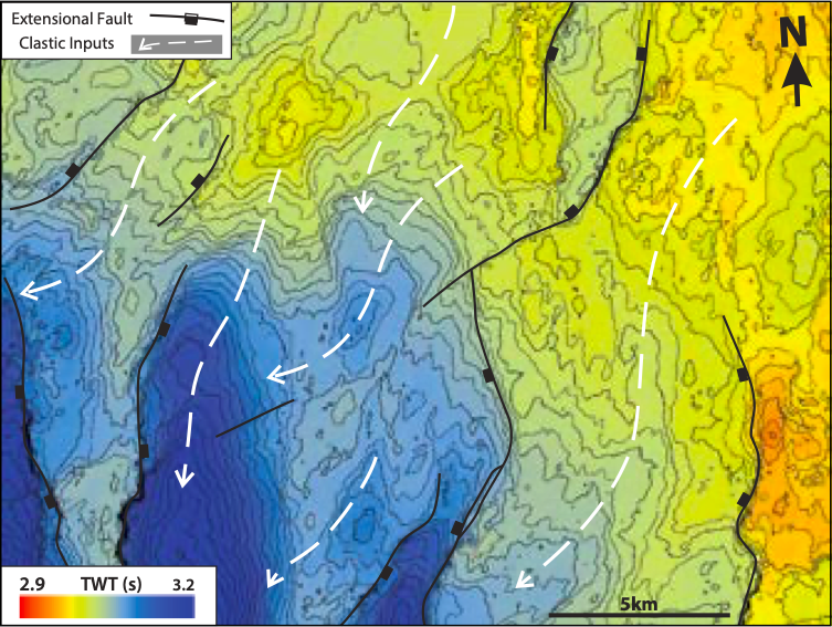
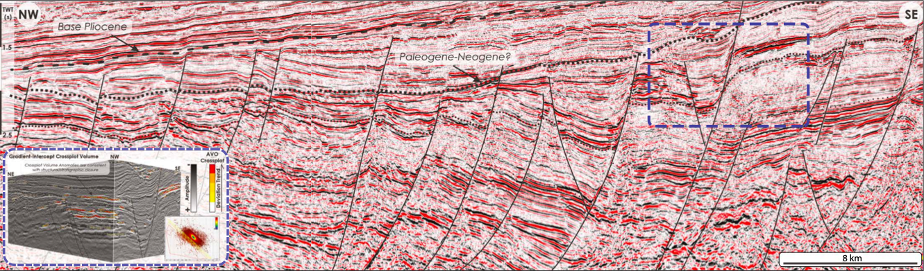
Reservoir: Reservoir properties are proven in clastic sediments deposited since the main syn-rift period in the Lower and Upper Cretaceous. Paleocene-Eocene sands turbidites were encountered in well 7216/11-1S (Figures 1 and 2). Fault chronology may have strongly influenced the provenance and distribution of the Upper Cretaceous and Paleogene turbidite systems. Coarser clastic deposits are more likely to be present within the syn-sedimentary growth of the faults. Regional tectonic subsidence has shifted most of the turbiditic input southward, flowing into the Sørvestsnaget Basin, even parallel to fault trends (Figure 3). Turbidite sands are marked by strong amplitude events and are frequently associated with AVO anomalies. Quantitative amplitude studies can be a useful tool to isolate the event or interval of interest. Interpretation of AVO responses will require accurate assumptions to model the anomalies; petrophysical information is currently limited to regional stratigraphy and the few drilling results potentially available.
Trapping mechanism: Cretaceous-Paleogene tectonism has created numerous structural 4-way dip closures, several kilometers wide (See 3D image on foldout on page 42). Large prospects may combine structural relief and sediment patterns along regional dips. The risk of trap integrity exists for shallow prospects close to or above the Paleogene-Neogene unconformity, which may have been exposed during the Pliocene.
Additional prospectivity for oil and gas
Spectrum’s modern 3D multi-client seismic coverage over the Western Barents Sea allows detailed analysis of the petroleum system elements resulting from Atlantic margin processes. This highlights significant additional hydrocarbon prospectivity in relatively unexplored Cretaceous-Paleogene plays proven in other sectors of the Atlantic Margin in Norway and UK.