
NVG: igniting exploration
How a high quality seismic dataset can impact regional exploration in a mature basin.
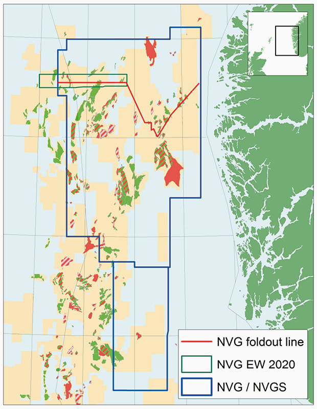
After the 2013 Exploration Revived Conference in Bergen highlighted the need for improved data quality and regional seismic coverage in the Northern North Sea, CGG acquired the Northern Viking Graben 3D BroadSeis™ seismic dataset in a north-south direction in several phases (NVG and NVGS), from 2014–2018. This contiguous dataset enables seamless interpretation of the petroleum provinces and structural elements, from the Stord Basin across the eastern Utsira High to the Northern Viking Graben. An example of the latest PSDM data can be seen in the main foldout line. Several discoveries made in the Northern North Sea since the survey was acquired, testimonies from E&P companies and acknowledgement from the Norwegian Petroleum Directorate, attest to the impact of the dataset. With several of the producing fields having their lifetime extended by 10–20 years there is a drive to develop additional resources. This, in combination with the recent success rate, suggests a continued high level of exploration and development in the area for many years to come. To assist this, CGG recently completed the first phase of acquisition of east-west new data over the existing NVG that, together with a complete reprocessing of the existing data, will create a dual-azimuth volume over the Northern Viking Graben, with the plan to continue east-west acquisition in the coming years.
Developing plays
Exploration in the Northern North Sea has a long history with several hydrocarbon plays present, yet new fairways are still being identified and exploration models developed. The Middle Jurassic Brent Group is an example of an established producing play holding important reservoir rocks. Figure 1 highlights the fault complexity at the top Brent Group which hosts multidirectional fault systems. In fields such as Snorre, the entire Jurassic section is eroded and not present. The Dugong oil and gas discovery (2020), which encountered hydrocarbons within the Rannoch Formation (Brent Group) on the northern flank of the Snorre structure, opened up an underexplored region for the Brent play. This, and the Echino South discovery (2019), highlights the importance of having a high quality dataset to identify new targets in proven mature structural plays through detailed mapping of the trap elements.
The Upper Jurassic Intra-Heather Formation sands (Sognefjord, Fensfjord Formation and equivalents) have been re-explored over the Horda Platform, the Uer and Lomre Terraces and in the Måløy Slope in the past decade. Wells targeting these sands have resulted in many recent discoveries (see seismic foldout line). The high number of new discoveries and remaining potential within these sands show the continued impact of a high quality regional seismic dataset, especially at depth.
Imaging of the Upper Jurassic Munin sands (and equivalents) over the Tampen area pose significant challenges, as they sit just below the BCU (Base Cretaceous Unconformity) and often below the hard limestones, marls and reworked carbonates that make up the Mime Formation (Lower Cretaceous). This is where some improvements are expected to be seen from imaging of the dual-azimuth data volume, which will result in a better signal-to-noise ratio, and enhance illumination and resolution, which are important for unlocking the remaining potential of this play.
After the initial discoveries of the Lower Cretaceous sands in the 1990s, the Agat play was not developed further. The sands and their relationship to basement structures and Jurassic canyons are now easily mappable with seismic on a regional scale. The Schweinsteiger, Duva (Cara) and Presto wells have tested the play more recently while others, such as Havhest, are planned and other prospects are yet to be defined.
The Paleocene Lista Formation sandstones are producing from the Gullfaks field and oil shows have been encountered at this level in the Tordis and Borg fields. Dual-azimuth data may help with regional mapping of this complex play. These sands, which have been identified within the Tampen area and on the eastern margin of the basin, require further investigation to mature this play further.
Establishing new plays
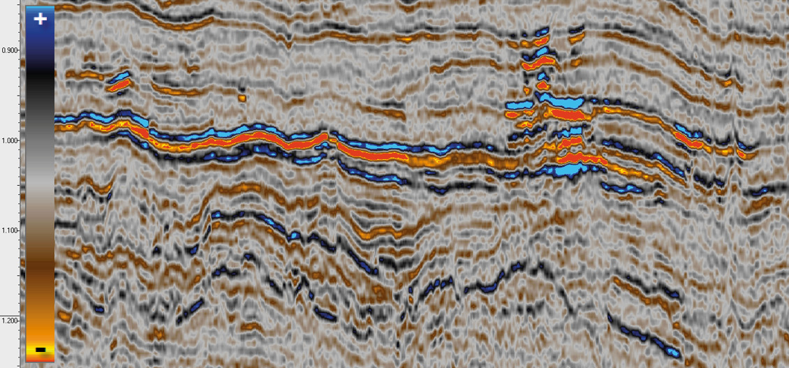
One of the most recent exciting oil discoveries in the Northern North Sea was Liatårnet (2019), which proved petroleum in the Miocene Skade Formation with an appraisal well planned for 2021/22. With the Eocene Frigg sands commonly being the main producing interval within the Cenozoic, the Liatårnet well has ignited interest in a shallower play in the NVG area. Figure 2, taken from the NVG north-south PSDM dataset, shows brightening at the reservoir level where the approximate lateral extent of the discovery can be identified. The new dual-azimuth data volume should significantly improve seismic imaging of the Cenozoic sands.
The next phase
CGG’s initiative to add a regional state-of-the-art dataset in the east-west direction will be an important step in enhancing exploration in this region. This next phase of acquisition and reprocessing will bring a step-change in both resolution and structural imaging through a multifaceted approach. The first clear benefit will be enhanced illumination of key target level faults from the second azimuth. The many regional stress fields in this part of the North Sea have aligned key structures in the north-south direction. This is particularly important sub-BCU, where the complexity of the fault systems increases and illumination of reservoirs is heterogeneous. East-west acquisition should significantly improve the available recording aperture to aid identification of these faults, especially when combined with the original north-south BroadSeis data in a full multi-azimuth reprocessing flow.
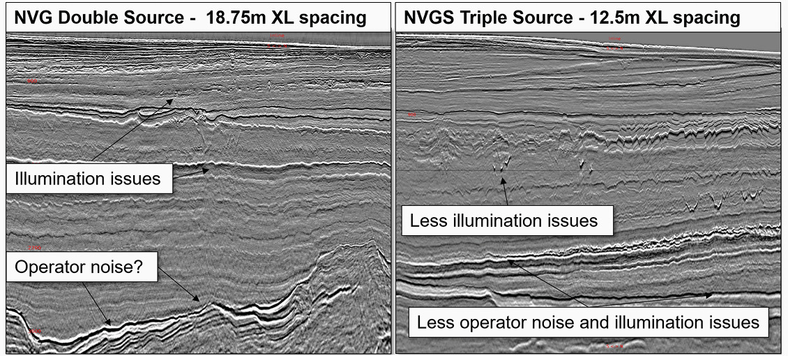
Further imaging enhancements are anticipated from having the more densely sampled triple-source data. This increases the ability to sample spatial reflectivity changes and hence mitigate corresponding operator noise. This is seen in Figure 3 comparing the NVG (north-south PSDM, double-source) and the NVGS (north-south PSDM, triple-source) data. Beneath injectites and along complex structures such as remobilised chalk or the BCU, the triple-source data shows fewer illumination issues and less operator noise. Beneath shallow attenuating bodies and under injectites, signal-to-noise ratio and resolution will benefit from a complementary azimuth, especially when combined with targeted dual-azimuth processing techniques. Reprocessing of the underlying data is also expected to significantly enhance imaging. Modern techniques such as 3D source and receiver deghosting, and multi-channel 3D deconvolution imaging and multiple modelling are likely to improve resolution and demultiple in this region.
The reprocessing of the underlying north-south BroadSeis data, combined with the illumination and resolution-enhancing benefits of the densely sampled wide triple-source multi-sensor east-west data, is expected to overcome multiple imaging challenges. This new dual-azimuth dataset will aid continued exploration for years to come, with the hope for new discoveries and further development of the area.


