
A new and improved velocity model for the Southeastern Caribbean
Generate powerful insights for the 2022 Barbados and T&T Offshore Licensing Rounds with the CAMDI (2019) and Barbados (2013) data.
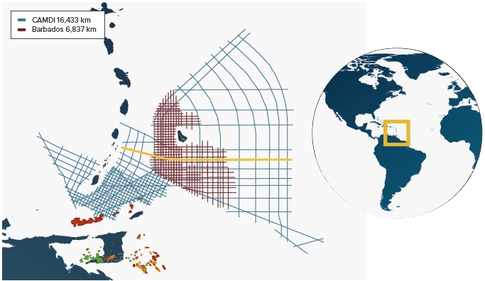
During 2018 and 2019, Geoex MCG acquired the Caribbean Atlantic Margin Deep Imaging seismic survey (CAMDI). This survey consists of 16,443 km MC2D long offset (12 km) and deep records (18 seconds) seismic data. This transnational survey continuously covers acreage across the maritime borders of Barbados, Trinidad & Tobago, Grenada, and St. Vincent.
The survey was originally designed in two grids. The regional grid is meant to provide a better understanding of the regional tectonic framework of the different basins along the Southeastern Caribbean and Western Atlantic Margin of Northeast South America.
The detailed grid, offshore Trinidad & Tobago and Grenada, is designed to provide more detail, outline potential prospects and tying the producing areas in Trinidad & Tobago to the underexplored deeper part of the Tobago Trough.
The CAMDI survey can be combined with the Barbados Survey acquired in 2012/2013 by Geoex MCG to outline potential prospects in Barbados. The Barbados Survey is comprising 6,837 km of long-offset 2D seismic data over a 14 x 14 km and 7 x 7 km prospect grid, covering the Barbados Trough, the Tobago Basin and crosses the Barbados Ridge.

Both surveys provide clear imaging and broad coverage of all play elements in the region, including the oil prone La Luna source rock or its regional equivalent.
Initial velocity model
The original processing sequence used a state-of-the-art broadband solution. A detailed velocity grid, that was estimated by global tomography was input into both the pre-stack time migration (PSTM) and the pre-stack depth migration (PSDM). This velocity model is structurally consistent, containing detailed shallow geological features such as mud volcanoes and potential gas anomalies (see left).
However, there is a lack of available well data in the area. In order to increase the accuracy of the velocity model, wide-azimuth beam tomography data was used that is typically unavailable in traditional tomography.
Beam tomography
Before beam tomography can update the velocity, the seismic data must be converted to beams, using a once-per-dataset, velocity-free procedure (Popovici et al., 2013 and Popovici et al., 2017).
The next step is to migrate the beams using the available velocity model. After the migration is completed, each of the resulting depth migrated beams contain the following information (among others):
- Seismic wavelet: The time signature of the event that is imaged;
- Beam correlation point: The (x, y, z) point in the subsurface locating the structure that the beam is imaging;
- Reflection angle: The angle at which the seismic waves reflected from the structure;
- Structural plane: These are the x and y dips of the subsurface structure. They are equivalent to the plane tangent to the structure at the reflection point.
We use this information to make groups of beams that are imaging the same structure. As with traditional tomography, the assumption is that beams that image the same structure should place it at the same point in the subsurface and any discrepancies are due to errors in the velocity.
For each group, we first align the beam seismic wavelet temporally. Then we calculate the spatial shift necessary to align the structure. We convert these space shifts to time shifts using the velocity to obtain a velocity correction along the ray trajectory. This correction is the residual for the tomographic equation and the tomographic matrix is obtained from the ray trajectories. The velocity update is obtained by solving the tomographic linear system of equations. Following the update, the procedure is restarted from the migration stage.
Since the above workflow does not require image gather or user input, beam tomography velocity updates can be done very rapidly so that the final model is the result of hundreds of iterations. Nonetheless, velocity model building is not a “black-box” procedure – image gather and other QC attributes can be generated at certain iteration numbers to allow monitoring and supervision of the algorithm.

Updated velocity model
After 120 iterations of Beam Tomography, an updated velocity model was obtained (figure left). This new velocity model produces flattens gathers and results in an improved signal strength (figure below). All iterations were conducted using Kirchhoff pre-stack depth migration (PSDM).
Additionally, Gaussian Beam migration (GBM) and reverse-time migration (RTM) were used in the imaging process. The new velocity model is highly resolved, and consistent with the geologic structures, containing detailed and subtle velocity changes within the sedimentary sequence and highlighting shallow geological features such as mud volcanoes and gas anomalies.
New plays and prospects
All the components for successful exploration are present offshore Southeastern Caribbean. The seismic line shown in the foldout is located south of Barbados, from the Tobago Trough, through the Accretionary Prism and into the Atlantic Abyssal Plain. Several trapping configurations can be identified: channels, rollover structures and anticlines.
An integrated interpretation of both CAMDI and Barbados MC2D surveys has led to the identification of multiple prospects. These prospects are expected to be charged by the La Luna formation (or its regional equivalent). Structural and stratigraphic traps have been mapped out and Direct Hydrocarbon Indicators (DHI’s) can be observed in connection with many of these traps.
The Southeastern Caribbean area is an excellent exploration opportunity, with only a few exploration wells are drilled in this vast untested area. Several world-class leads have been identified using both Geoex MCG surveys: CAMDI and Barbados.
Good quality offshore reservoirs appear in the data, optimizing the ‘below-ground risk’. Meanwhile, regional Governments have created an exploration environment optimizing the ‘above-ground risk’.
Ongoing licensing rounds
The Government of Barbados recently announced the schedule for their Offshore Licensing round. In addition, the Government of Trinidad & Tobago has recently also published the expected blocks on offer for Competitive Bidding in Q4 2022.
References
A.M. Popovici, N. Tanushev, I. Sturzu, I. Musat, C. Tsingas, S. Fomel; Fast Beam Migration Using Plane Wave Destructor (PWD) Beam Forming, 75th EAGE Conference & Exhibition, London, 10-13 June 2013.
A. M. Popovici, S. Fomel, N. Tanushev, I. Musat, I. Sturzu, C. X. Tsingas, Fast Beam Migration Using Plane-Wave Destructor (PWD) Beam Forming, U.S. Patent No. US9594176B1 (filed: Aug. 1, 2012, granted: Mar. 14, 2017).


