The Hoop Fault Complex is located in the northernmost part of the Barents Sea. North of the Maud Basin and along the narrow Hoop Basin a number of production licences have been awarded and six wells drilled in recent years. Two light oil and two gas discoveries have been reported, the most remarkable thing about them being their shallow depth – they are located in excellent Jurassic reservoirs only a few hundred metres below the seafloor.
Maximising the opportunity presented by shallow targets, the Hoop area has become a geophysical and geological testing ground for new technologies. Besides many new 2D seismic data sets and several seafloor sampling cruises, the area has a large continuous 3D seismic and 3D CSEM (controlled-source electromagnetic) coverage. Noteworthy among the new technologies tested are seismic de-ghosting processing techniques, P-Cable ultra-high resolution 3D seismic and induced polarisation (IP).
Interesting Structural Styles
Only a few deep north-north-east to south-south-west faults can be seen in and around the Hoop Fault Complex. These were active in Mid Triassic and Upper Jurassic times, as evidenced by thicker successions within the basin, consequently opening up the possibility of locally thicker reservoirs and source rocks. Mild shortening is also observed.
On the east side of the complex, in the area where the new oil discoveries are situated, intermediate deep faults are rooted in the Early Triassic. In the greater Hoop area, east to west trending shallow faults cross almost perpendicular to the older faults. These are important for the closures and leads seen in the Jurassic. In most cases, the faults continue as flexures at the onset of the Cretaceous. Most of these end in the upper channelised Upper Triassic and only a few offset the Mid Triassic. This points towards ductile Cretaceous and Upper Triassic, but a brittle Jurassic at the time of creation. Offsets of more than 100m are compensated a few hundred metres below. There are several theories explaining this, such as differential compaction due to diagenetic processes or being triggered by the channel systems in the Upper Triassic. Alternatively, perhaps the compensation could be due to salt movements deeper down. The problem with these theories is the regional scale of faulting which can be seen all across the large area covered by 3D seismic data. These Jurassic east to west faults can be followed westward to the Stappen High, several hundred kilometres away and in a totally different structural setting, indicating a more regional driver for these faults.
Regional scale bending or mild east-west strike folding/bending of the northern Barents succession may provide the regional mechanism required. In the upper part of a gentle fold, ductile layers (Cretaceous and Upper Triassic) might compensate the extension by stretching/thinning whilst more brittle layers (Jurassic) show extensional faulting. Weak compressional features or shortening have been observed on the large main faults deeper down.
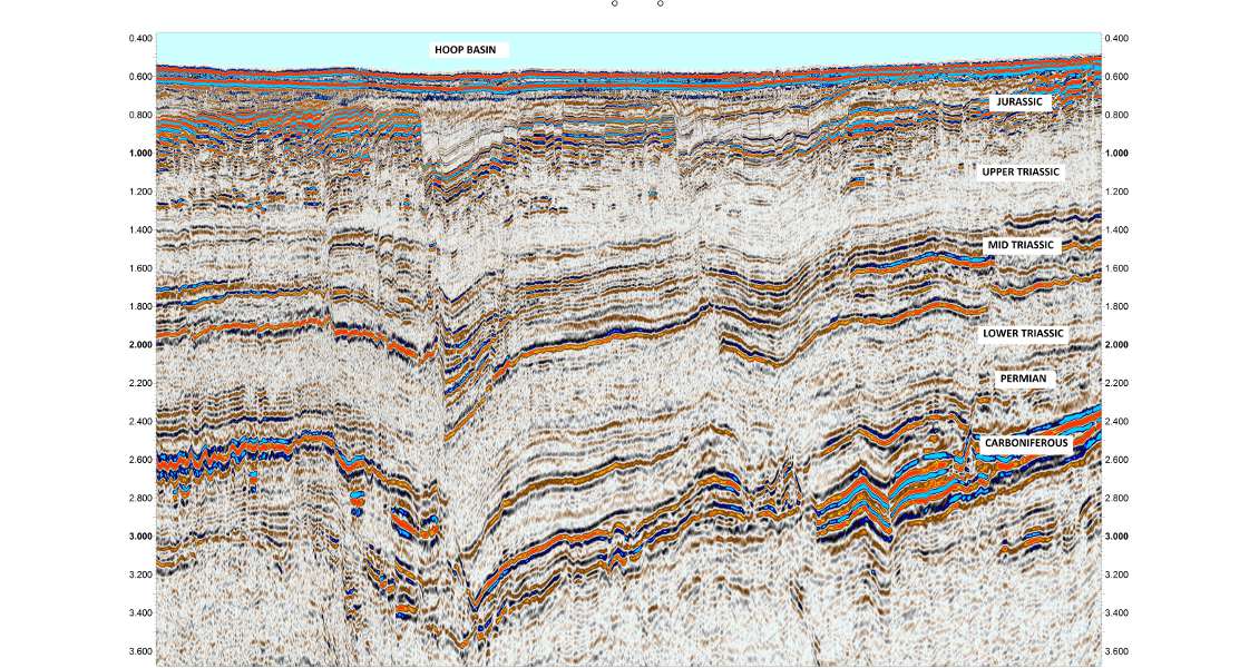
Seismic section in the Hoop Basin area. The area has a condensed geologic succession visible here from a Devonian or older seismic basement to the Lower Cretaceous with a thin Quaternary cover. The main reservoir-prone units are Permian karstified carbonates, Mid Triassic and Upper Triassic sandstones, Lower to Mid Jurassic sandstones and potentially Barremian sandstones. The main source rocks are of Mid Triassic and Upper Jurassic age. (Source: TGS)
Promising Reservoirs
The generally condensed Mesozoic succession in the Hoop area allows us to assess even Palaeozoic rocks as potential reservoirs. The recent ‘Gotha’ oil discovery in the southern part of the Loppa Ridge south of Hoop proves up a karstified carbonate play, giving hope for similar karstified carbonate reservoirs in the western part. Here, in the continuation of the Loppa High, the Mesozoic succession is uplifted and partly eroded, bringing Palaeozoic carbonates into a shallow position.
The Triassic succession is dominated by large scale deltaic deposits. High clinoforms from coastal progradation events in Mid Triassic shale out in the deep marine conditions towards the west. Potential sand in topset layers of these clinoforms, especially in the regression style prograding episodes, could create large stratified traps. The Late Triassic consists of a thick package of channelised coastal plain deposits that are also likely to contain good reservoir rocks. Two high-quality Jurassic reservoirs with thicknesses up to 70m are reported from the new wells. The Jurassic succession thickens within and on the eastern flanks of the Hoop Basin. The light oil discoveries in the Jurassic play make these the main targets to be tested further by the industry. The lowermost part of the Cretaceous is preserved and thickens significantly westward over the Fingerdjupet sub-basin with potentially sandy Barremian prograding units.
New and Innovative Seismic
At normal prospect depths of 2–4 km, the overburden is filtering or attenuating higher frequencies. At best, these targets have seismic frequencies up to 30 Hz, which limits the details of sedimentary patterns or subtle hydrocarbon effects that can be seen in the seismic.
Jurassic reservoirs in the Hoop area, however, are typically less than 1,000m below the seafloor. These extremely shallow targets create an opportunity for new and innovative seismic acquisition and processing, as well as technologies with higher resolution. When coupled with the high exploration activity in this area, advances are continuous and challenge-driven. By way of demonstration, the recent testing of P-Cable seismic acquisition and de-ghosting processing using TGS’ proprietary Clari-Fi™ technology has opened a previously unseen window to the subsurface that provides more certainty in lead identification and prospect appraisal, as well as reduced exploration risk.
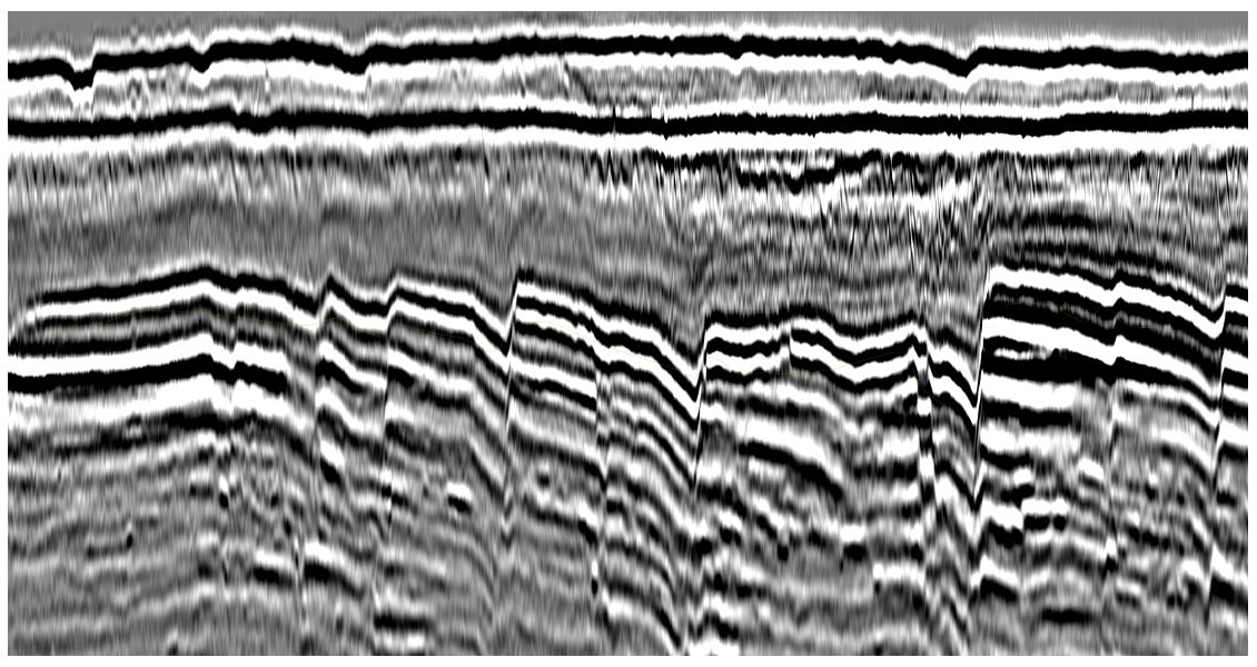
Two seismic lines from the same location. The first image shows conventionally processed semi-high density 3D data; the second image shows P-Cable and Clari-Fi processed data. The section is approximately 1 second two-way time and images the Quaternary, Lower Cretaceous, Jurassic and the uppermost part of Triassic. The second strong event in the middle of the first figure is the topmost Jurassic reservoir. (Source: TGS)
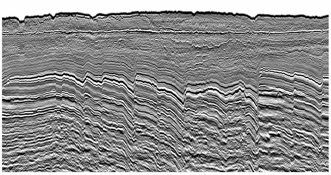
Two seismic lines from the same location. The first image shows conventionally processed semi-high density 3D data; the second image shows P-Cable and Clari-Fi processed data. The section is approximately 1 second two-way time and images the Quaternary, Lower Cretaceous, Jurassic and the uppermost part of Triassic. The second strong event in the middle of the first figure is the topmost Jurassic reservoir. (Source: TGS)
More than 20,000 km2 of semi-high density 3D seismic has been acquired in the Hoop area in recent years using a 3D spread of 10 streamers, 6,000m long and 75m apart, with streamers at 9m depth and gun arrays at 7m. As Jurassic targets lie before the first seafloor multiple, and customarily at less than 1,000m depth, P-Cable seismic is applicable here. P-Cable is an extreme type of 3D technology – with a typical 100m spread comprising 16 streamers, only 25m long, 12.5m between cables, streamers at 2m and gun at 2.5m depth – which maximises the potential of streamer acquisition technology to meet the specific needs of explorationists in this area.
On conventional 3D seismic processing with 4 ms vertical sampling, the contributing seismic frequencies range between 5 and 65 Hz. Clari-Fi de-ghosting processing techniques with 2 ms vertical sampling have been shown to double the measured frequencies in the top section up to 120 Hz. The P-Cable data processed at 1 ms and de-ghosted using Clari-Fi have contributing frequencies past 250 Hz in the top section.
As a result of drilling success, the Jurassic reservoirs are in focus. When imaging data based on conventional seismic, the two proven Jurassic reservoirs (the Stø and Normela Formations) are hard to assess in terms of reservoir thickness and vertical stratigraphic heterogeneity. Thickness variations start to be seen in the Jurassic reservoir levels on the de-ghosted 2 ms processed data, and sand and shale interpretation is also possible on the relatively thin reservoirs.
On the P-Cable ultra-high resolution 3D seismic, small and subtle sedimentation features like individual meandering channels with accretion of point bars and shore-face deposits including beach ridges can be identified. Hydrocarbon indicators such as flat spots and soft kicks, commonly seen in the Jurassic here, become sharper. On some leads, even a second flat event is seen.
CSEM and Seafloor Sampling
Since 2008, CSEM data has been acquired in the Hoop area and the major part is now covered with 3D CSEM data. The shallow targets make CSEM technology particularly applicable in this area. Numerous CSEM anomalies in different depths have been observed. To date, all of the oil and gas discoveries have been supported by CSEM anomalies with the exception of one dry well. Several such anomalies are observed on Jurassic leads elsewhere, but well-defined anomalies are also seen in the Cretaceous (Barremian) prograding system. In the western side of the Hoop Basin large CSEM anomalies are observed within the Triassic succession. Quite a few CSEM anomalies point to large structural and stratified traps in the mid-Triassic coastal prograding units and at specific clinoforms. In the east side of the Hoop Basin anomalies are seen in the channelised Upper Triassic, pointing to combined structural and stratified traps in this well-developed system.
Last year a seafloor sampling cruise (gravity coring) was carried out in the area. The sampling was done along three transects east and west of the Hoop Basin. The drop sites were densely spaced and carefully selected based on hi-res 3D seismic and sub-bottom profiler data. All the well locations in the area were also sampled for reference and background information. Three independent laboratories were used to analyse the data for the most trustworthy interpretations. The results suggest two types of oils, C5-7 and C8-14, in the area. Strong anomalies of oil microseeps were detected above specific Jurassic leads and oils were detected on both sides of the Hoop Basin.
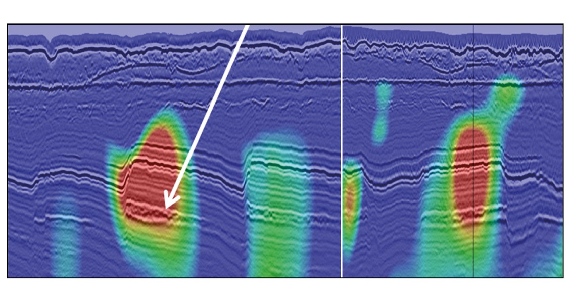
Figure shows HR14 (P-Cable 3D seismic data (courtesy of WGPS) – inline (left) and x-line (right)) with CSEM overlay (courtesy of EMGS). The P-Cable data has greater resolution in the Jurassic reservoir. Sedimentary features within the closures correspond to CSEM anomalies (arrow). (Source: TGS)
Untested Plays and Leads
In the greater Hoop area (>25,000 km2) there are still many untested plays and a lot of leads in the now proven Jurassic play. The area has significant potential. In the current constrained economic environment, it becomes increasingly important for oil and gas exploration companies to be able to reduce their risk by investing in areas with proven hydrocarbon potential – and also ones where they can rely on the best available geoscience-driven data to inform their energy decisions.
Please note that the copyright in these images is retained by TGS-NOPEC Geophysical Company ASA.


