Open running room in an emerging basin
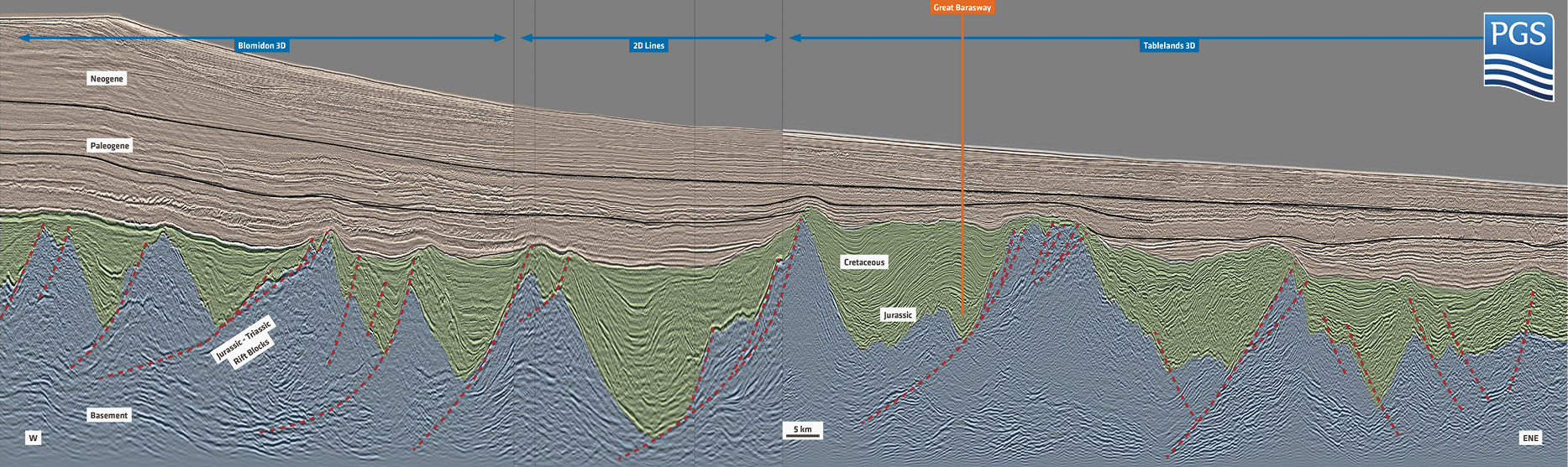
Three divergent plate tectonic systems control the offshore Grand Banks shelf platform. To the south, the Newfoundland–Gibraltar fracture zone limits the Triassic to Jurassic opening of the Central Atlantic. The northern shelf edge reveals a complex tectonic evolution related to the Cenozoic opening of the North Atlantic Basin and subsequent development of the southern Labrador Sea. The eastern Grand Banks shelf edge documents an intermediate stage in the northward migration of the Atlantic system and is dominated by the separation of the Iberia micro-plate from Avalonia, which completed after a Jurassic to Cretaceous rift stage. The rift-related extensional tectonics is prevalent throughout the Grand Banks subsurface (Figure 1) and underneath its present-day slopes. Extensional structures are the major element of the proven petroleum systems in terms of source rock presence and its maturity, due to the variable overburden in extensional systems. It further controls the reservoir distribution relative to structural highs and associated trapping mechanisms. Reliable seismic data significantly contributes to reservoir risk mitigation and improves the success rate for exploratory drilling.
Subsurface integration with modern 3D seismic data
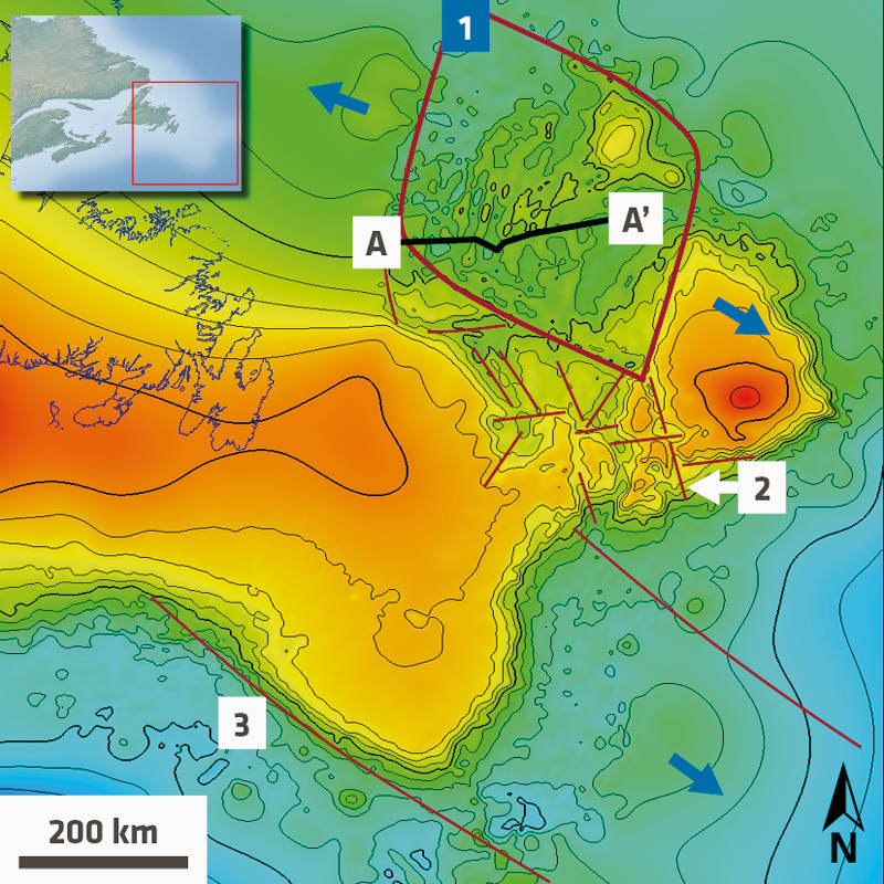
Regional seismic data analysis, based on 2D lines and extensive 3D multisensor broadband seismic coverage, suggests that the Orphan Basin formed as a pull-apart arrangement that is transient into Riedel-shear dominated arrays of extensional faults towards the prolific hydrocarbon domain of the Grand Banks distal shelf (Figure 2). The grain of the rifting architecture at the Grand Banks subsurface is evident from the morphology formed along the base of the passive margin sequence (Cretaceous Unconformity).
This reveals a NW–SE principal extension direction for the Orphan Basin based on the consistent regional trend of the underlying half-graben highs, while the Flemish Cap represents a rifted basement block that has been displaced by the Orphan extension. That rift pattern forms a rhombic shape, bound by a northern lineament that was presumably reactivated as a transform system during the Cenozoic North Atlantic opening, while the western lineament forms the conjugate to the Flemish Cap. The southern lineament marks the transition into an array of horst and grabens that indicate a crustal extension system with a Riedel-shear component, which is compatible with the simultaneous extension in the adjacent pull-apart. The Jeanne d’Arc or Flemish Pass sub-basins formed early in this system, while the Tableland Basin reaches into the pull-apart section of the Flemish Cap.
The Grand Banks basins have a prolific, rift-related petroleum system in common, which is primarily sourced by Kimmeridgian to Tithonian shales. The Great Barasway well, which successfully encountered an Upper Jurassic source rock sequence in the greater Orphan Basin, is illustrated on post-drill 3D seismic data (Figure 3).
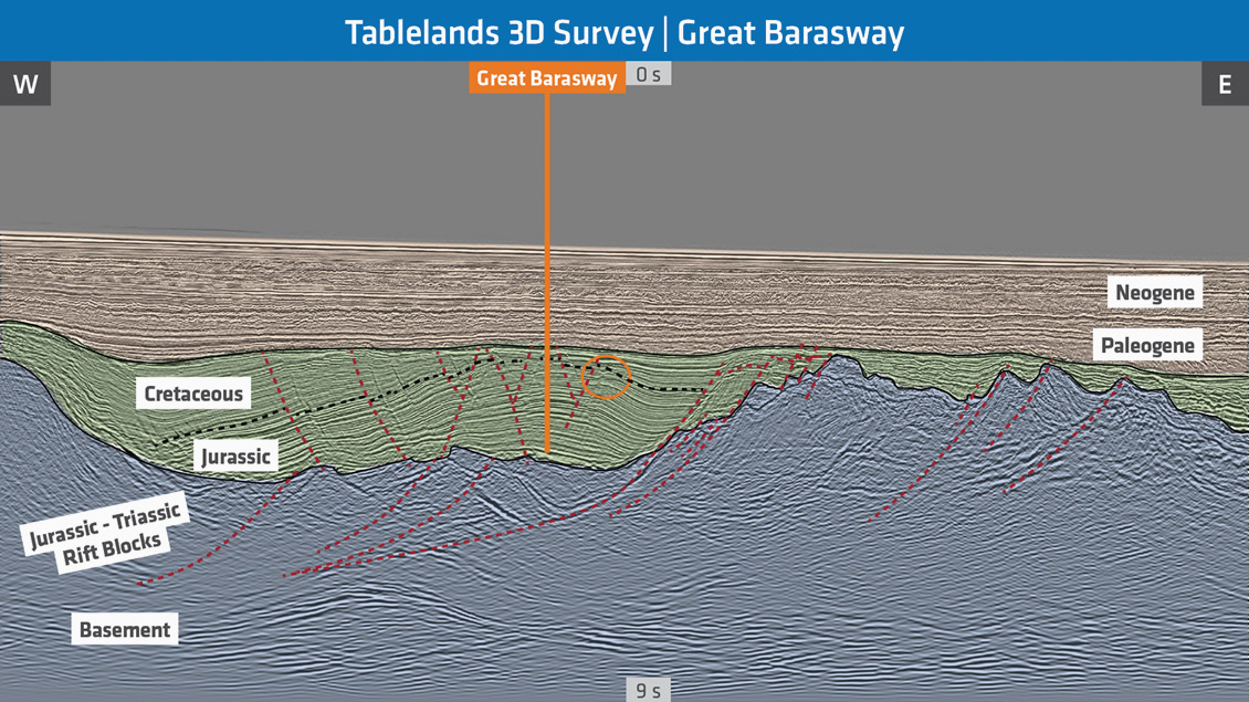
The seismic section reveals an extensional roll-over anticline driven by an eastward dipping low angle detachment fault, with the exploratory well targeting the crestal structure. Underneath the passive margin unconformity, the drilling merely found a reduced Cretaceous section before encountering the Upper Jurassic source rock sequence at a relatively shallow and immature depth. The 3D seismic allows for reliable tracking of the source rock intervals into the deeper roll-over syncline or half-graben where higher thermal maturity levels are likely. Evidence for up-dip hydrocarbon indicators are present on the 3D seismic line with anticlinal keystone faults forming the critical trapping mechanism for potential sandstone reservoirs (e.g., Figure 3).
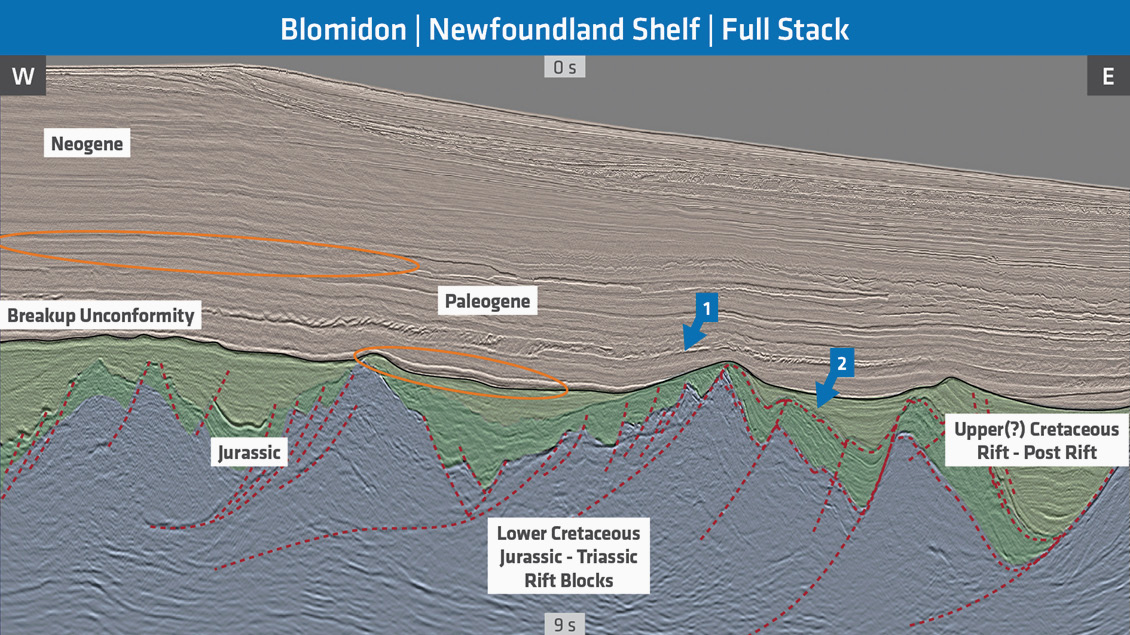
The locus of crustal extension in the greater Orphan Basin may have shifted during the Jurassic to Cretaceous as indicated by migrating depocenters for the sedimentary syn-rift accumulations (Figure 1). High quality 3D seismic imaging of the rift architecture and syn- to pre-rift sedimentary signature offers a complete picture of the depositional/burial history and provides enhanced control for modeling the petroleum system. Figure 4 illustrates an east–west section from a recent 3D survey in the Orphan Basin that resolves the structural elements of the rift section in conjunction with the imaging of an early syn-rift or pre-rift sediment sequence, possibly of Jurassic age, followed by a well-imaged syn-rift half-graben fill, presumably Cretaceous of age. The seismic data highlights amplitude responses for potential hydrocarbon reservoirs in the Cretaceous sediments on-lapping onto the structural highs and in late to post-rift deposits draping the structures. The assessment is based on the semi-quantitative analysis of potential exploration objectives and a quick, automated horizon interpretation to help screen the interval of interest. The analysis also comprises the passive margin sequence which gradually builds Paleogene to Neogene cover sequences of progradational sedimentary wedges, as illustrated on Figure 4.
New play concepts
The passive margin slope sequences of the Grand Banks reveal a promising play concept comprising Upper Cretaceous to Paleogene slope to basin-floor fan sand fairways. Prolific play analogs have been documented elsewhere along the margins of the greater Atlantic system.
This play type differs from the proven petroleum systems of the various sub-basins covering the Grand Banks area and it is assumed to be primarily sourced by organic-rich Albian, Cenomanian, Turonian (ACT) shales that have been penetrated and analyzed in research wells of the International Ocean Drilling Program which were located at the distal sector of the basin. The ACT source rock interval is associated with the separation of Newfoundland and Iberia and was presumably deposited in partially restricted marginal basin settings during the early drifting stage, while the developing slope of this basin received clastic input from the Canadian Shield via sand channel and fan complexes.
De-risk emerging Orphan Basin with optimized imaging
PGS and partners (Nalcor & TGS) classify the Grand Banks region as emerging hydrocarbon basins and acknowledge its exploration and production potential. This is the primary driver for our continuous commitment to high quality GeoStreamer 3D seismic acquisition campaigns accompanied by innovative time and future depth processing of the seismic data. The major focus of the seismic program aligns with the industry demand to optimize seismic imaging to completely capture the petroleum system and assess the reservoir potential of the rift play and the overlying passive margin sequences. The broadband multisensor seismic products offer a reliable database for appropriate exploration risk mitigation and potential drilling hazard assessment in this emerging basin.


