Work done by Polish scientists in the early 1800s laid down the foundations of the modern oil industry.
In the late 19th and early 20th centuries the northern segment of the Carpathians (present-day south-east Poland and western Ukraine) was one of the most prolific hydrocarbon-producing provinces in the world. Before that, however, at the beginning of the 19th century, when modern geology was being born in Germany, France and Great Britain, an attempt was made to summarize field observations from the Carpathians in the form of a geological map, showing, amongst other things, the natural field occurrences of hydrocarbons such as oil seeps and gas leakages.
This map was prepared by Stanisław Staszic (1755–1826), a Polish priest, philosopher, statesman, geologist, scholar, poet and writer, and the leader of the Polish Enlightenment. Staszic graduated from a Jesuit school in Poznań, and then continued his studies in France and Germany, where he was taught by eminent scholars such as Georges-Louis Leclerc Buffon. Later, he translated Buffon’s seminal work Les Époques de la Nature into Polish. Staszic was a very active supporter of industrial development in Poland, organized a mining school in Kielce, and served as president of the Society of Friends of Sciences (Towarzystwo Przyjaciół Nauk) in Warsaw for almost 20 years, from 1808 to 1826.
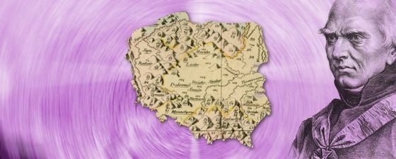
Map Shows Seeps and Hydrocarbons
His first geological publication, entitled O Ziemiorodztwie gór dawney Sarmacyi a późniey Polski (On Earth formation of previous Sarmatia, later Poland), appeared in 1806. Staszic compiled this and several other essays into his geological opus magnum, a book published in 1815 and entitled O Ziemiorodztwie Karpatów i innych gór i równin Polski (On the Formation of the Carpathians and Other Mountains and Lowlands of Poland). This book was accompanied by an atlas containing a truly impressive map entitled Carta geologica totius Poloniae, Moldaviae, Transylvaniae, et partis Hungariae, et Valachiae (Geological Map of the whole of Poland, Moldova, Transylvania and parts of Hungary and Wallachia). Dated 1806 (nine years before the famous William Smith map of England and Wales), this map is relatively unknown to geologists and historians of geology, especially those from outside Poland, but it certainly deserves much better recognition.
Hand colored, the map was published on four large 66 cm x 45 cm sheets, and covers approximately a million square kilometers – a very large area which stretches from the Baltic Sea to the Black Sea. Staszic adopted the rock nomenclature used by the famous German geologist Abraham Gottlob Werner, and used colours and numbers to indicate 150 different types of rocks and ore deposits. Of particular interest to petroleum geologists are the numerous oil seeps and the different rock types containing hydrocarbons, abundantly shown in the Northern Carpathians.
This geological map and other publications by Stanisław Staszic, together with the achievements of Ignacy Łukasiewicz (1822–1882), including the discovery of an efficient oil distillation process and the construction of a kerosene lamp, effectively laid the foundations of the development of the modern oil industry.
References
Grigelis A., Wójcik Z., Narębski W., Gelumbauskaite L.Z., Kozák J., 2011, Stanisław Staszic: an early surveyor of the geology of central and Eastern Europe. Annals of Science, 68: 199–228.
Sozański J., Kuk S., Jaracz C., Dziadzio P. S., 2005, How the modern oil and gas industry was born: Historical remarks. [in]: Golonka J. & Picha F.J., eds., The Carpathians and their foreland: Geology and hydrocarbon resources: AAPG Memoir 84, p. 811 – 834.
Wołkowicz S., Wołkowicz, K., 2014. Geological cartography in Poland in the 19th century. Geological Quarterly, 58 (3): 623–658, doi: 10.7306/gq.1198
Further reading from the GEO ExPro archive
Maps for Understanding the Earth by Jane Whaley
‘Strata’ Smith Enters the Digital Age by Peter Wigley


