A unique opportunity
Exploration interest in the North Sea is extending beyond the traditional areas and casting its eye upon frontier plays.
In this article we will show how the technological advancements of the dual-sensor broad bandwidth GeoStreamer® data reveal a new level of detail, highlighting structures not previously visible. We apply this to the definition of multiple Palaeozoic, Mesozoic and Cenozoic plays in UKCS Quadrants 9, 14, 15 and 16. Upper Jurassic deltaic to marine sandstones are the most important reservoir units on the platform margins (e.g., Claymore, Piper, Tartan), whilst the proven and potential targets on the main East Shetland Platform (ESP) range from Eocene to Palaeozoic in age (e.g., Mariner , Cairngorm).
Tertiary Potential
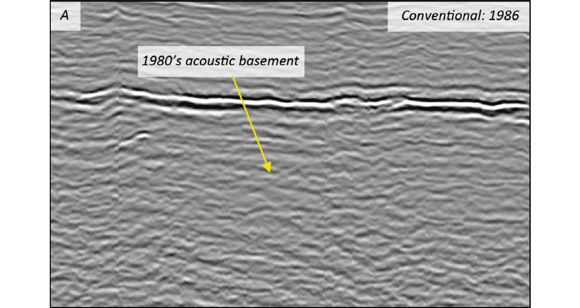
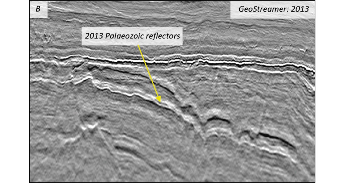
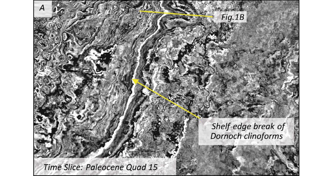
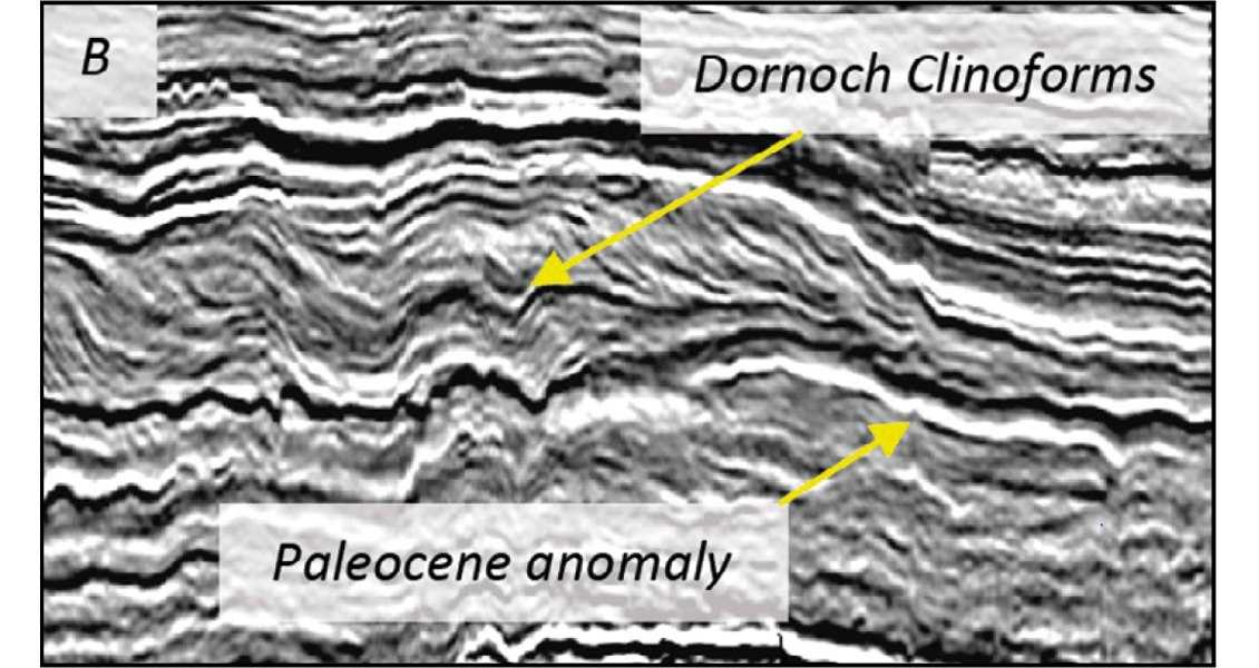
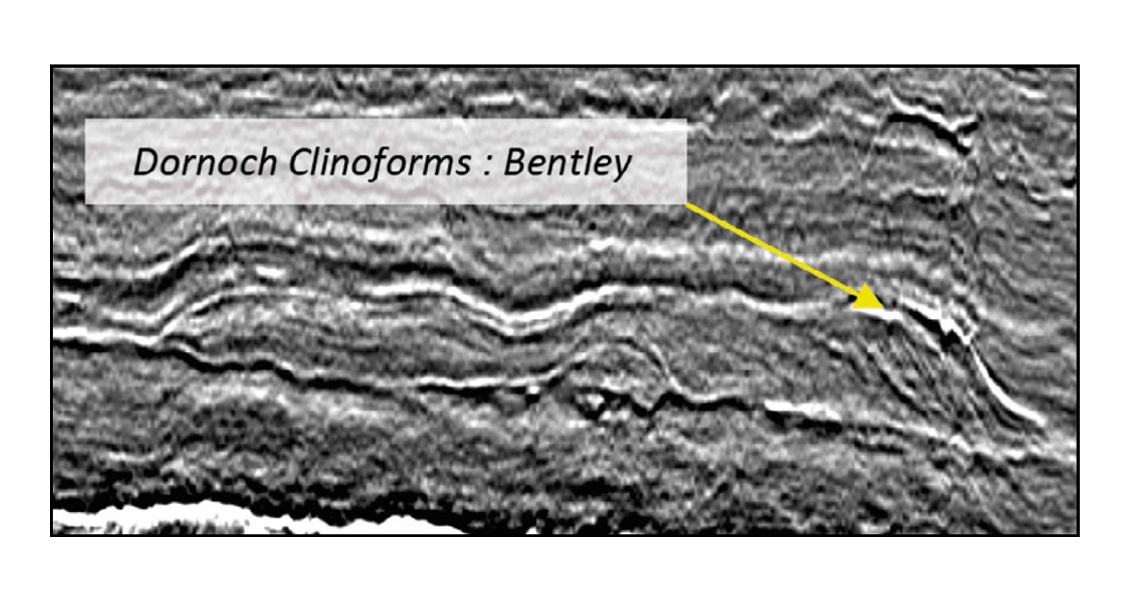
The Tertiary plays on the platform target shallow marine and turbiditic Paleogene sandstones, with key fields within the Dornoch, Lista, Sele and Vale formations (e.g., Mariner, Bentley, Kraken, Yeoman, in UKCS Quads 9 and 15). The high-fidelity of the GeoStreamer data improves imaging and interpretation in the Tertiary reservoir targets (e.g., Dornoch clinoforms, Figures 1–2). The additional undrilled Paleocene prospectivity of the Forties, Balmoral and Heimdal sandstones (Figure 1B) are also clearly identifiable and highlight new potential in this frontier area.
Palaeozoic and Mesozoic Potential
Several hydrocarbon discoveries in the Central North Sea have a working Palaeozoic (e.g. Cairngorm) or Early Mesozoic (e.g., Crawford) reservoir, proving the regional exploration value of these reservoir targets.
Fractured crystalline basement constitutes a reservoir component in hydrocarbon discoveries on the West of Shetland (e.g., Lancaster), Utsira High (e.g., Cliffhanger North, Edvard Grieg) and the eastern East Shetland Platform areas (Cairngorm). The Devonian alluvial ‘Old Red Sandstone’ forms a reservoir component in several hydrocarbon fields and discoveries, including Clair, Buchan, Stirling, Embla and Alma/Argyll. Buchan and Clair in particular are large fields (respectively, 220 and 1,100 MMboe total recoverable reserves), producing 25–34° API oil.
Carboniferous or Lower Permian Rotliegend sandstones are reservoirs in the Innes and Auk fields, in the South West Central Graben, and a subordinate component in Claymore and Highlander fields (UKCS Quad 14). Upper Permian fractured carbonates represent the main reservoir in Auk and Argyll/Alma and a subordinate component in other large fields, including Claymore, Johan Sverdrup and Ettrick.
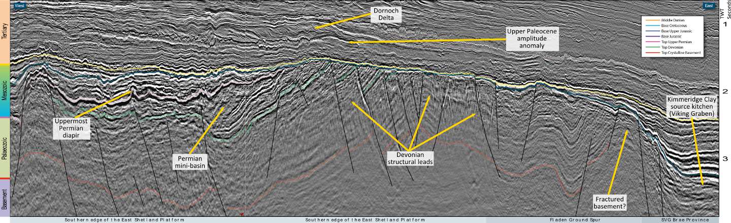
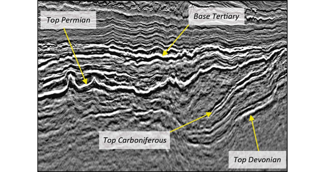
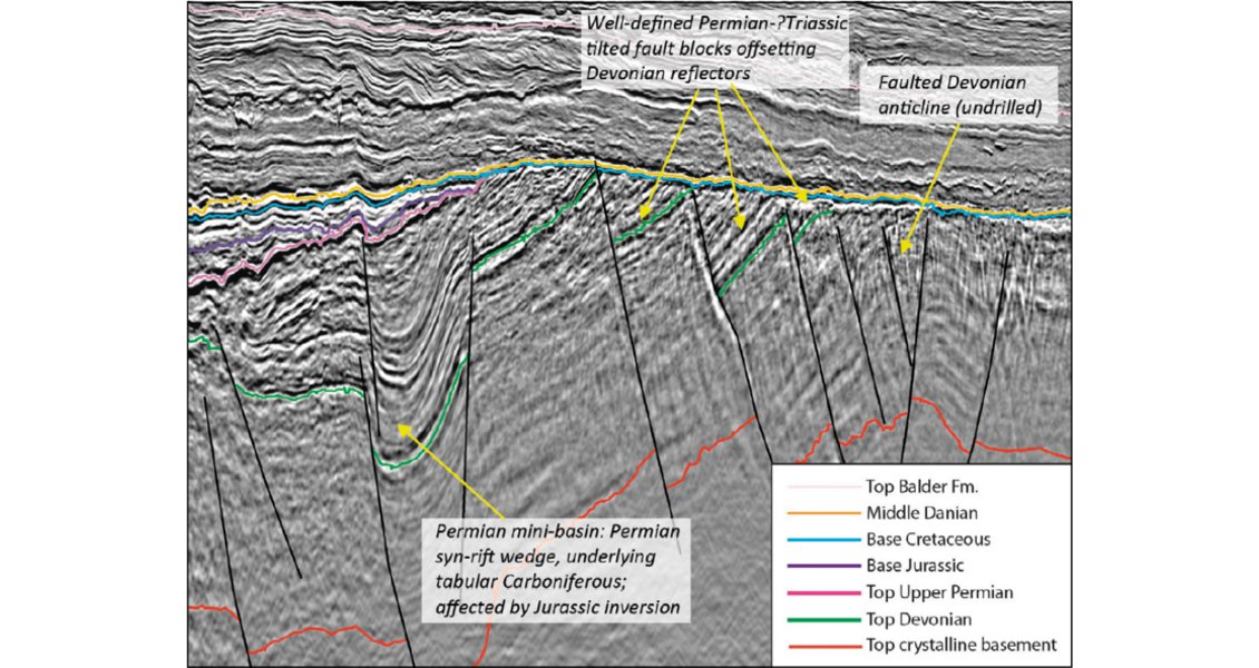
GeoStreamer enables improvements in seismic imaging in the deeper pre-Cretaceous section and has allowed the interpretation of the Palaeozoic horizons over the entire East Shetland Platform region for the first time, shedding new light on its evolution. Structural closures can now be mapped with confidence. A few of these are shown in Figures 3 and 4 . In particular, Figure 3 highlights undrilled Permian mini-diapirs with overlying potentially evaporite-cored Triassic-Jurassic anticlines. Furthermore, significant Permo-Carboniferous mini-basins and large Devonian structures (e.g., fault blocks and faulted anticlines) are clearly interpretable (Figure 4). These features are often truncated by the Base Cretaceous Unconformity (BCU) and sealed by the overlying Cretaceous and Tertiary strata.
Source Rock and Maturation History
Source rocks for the existing discoveries and additional leads on the platform could be provided by the upper Jurassic Kimmeridge Clay Formation. This unit is, however, thought to be immature over the East Shetland Platform, and lateral migration from the Moray Firth and Viking Graben source kitchens is understood to provide the charge for fields along the platform margins.
With questions surrounding long distance migration of this source, additional source potential, possibly from Devonian lacustrine shales, must be considered. The Devonian lacustrine shales are proven in the Inner Moray Firth (e.g., Beatrice Field), and several wells drilled Devonian source rock intervals over the East Shetland Platform (particularly, in UKCS Quads 9 and 14).
The key risks associated with the Devonian source rock are its distribution and the timing of maturity. If generation occurred early on, initial hydrocarbon accumulations might have been breached due to the later complex pre-Cretaceous tectonics.
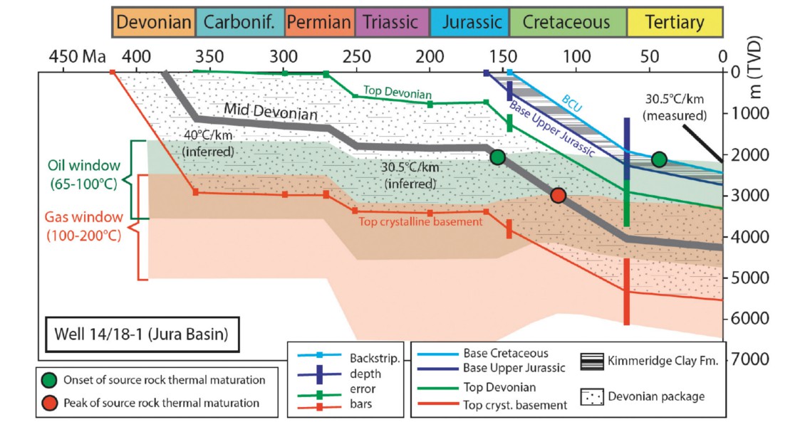
Temperature data from wells and geothermal gradients in geological analogues calibrate respectively the Palaeozoic and the presentday maturity model (Figures 5–6). In particular, Devonian mean geothermal gradients were constrained by post-orogenic extensional collapse analogues (c.f., West Italy, East Africa). Permian evaporites caused a geothermal decline; Jurassic rifting increased the gradient.
Seismically constrained thermal history modelling indicates that the Kimmeridge Clay is thin and at best marginally mature away from the graben axis. Furthermore, the mid Devonian source rock timing of maturation varies semi-regionally, but there are areas (e.g., Q14–15, Crawford area) where peak thermal maturation is believed to have been reached after the Jurassic. This post-dates the uplifting events which could have breached early hydrocarbon accumulations (Figures 5–6).
Glennie (2009) points out that higher sulphur oil is found in major Witch Ground Graben fields, such as Claymore (Figure 5), Tartan and Buchan. He suggests that this either represents a more sulphur-rich Jurassic facies or a contribution from a Devonian source rock.
Our analysis of a well close to Claymore (Figures 5-6) suggests that peak maturation of the mid Devonian was reached from the mid Cretaceous, which is compatible with migration into Jurassic structural traps, such as Claymore itself.
Summary
The East Shetland Platform and the surrounding Central North Sea area have many proven Devonian-Eocene fields and may still contain 1.9 Bbo and 3.4 Tcfg (USGS, 2005). Multiple plays have been identified across the platform area and include Palaeogene deltaic, shelfal and deep-water sandstones, Triassic and Jurassic sandstones, Permo-Carboniferous carbonates and sandstones, fractured Devonian sandstones and fractured basement in prominent structural traps. The Palaeozoic plays, in particular, have been successful in large fields such as Buchan, Clair and Auk, proving these units to be viable reservoirs, producing fields with >100 MMboe of ultimate recoverable reserves.
Potential oil-prone sources in the East Shetland Platform and Moray Firth regions may be provided by Devonian shales (e.g., Beatrice Field). Provisonal burial history modelling indicates that the best case scenario (late generation / expulsion) is viable over parts of the East Shetland Platform area, thus reducing the requirement of a long lateral migration from the Kimmeridge Clay source kitchen.
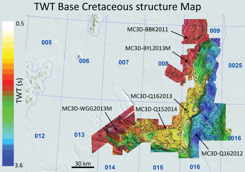
As 76% of the 205 wells penetrating pre-Jurassic units on the platform areas were drilled in the 1970–80s based on vintage seismic data, the East Shetland Platform remains poorly understood. With the acquisition of several recent 3D dual-sensor towed-streamer broadband surveys by PGS, there is now a unique opportunity to view the Palaeozoic reflectors with significantly more clarity (Figure 7). The existing coverage, combined with new 3D GeoStreamer acquisition over Quadrants 3 and 8, is allowing the true geological story and prospectivity to be unravelled.