Data, particularly information about subsurface geology, is key to successfully exploiting natural resources, be they mineral, hydrocarbon or renewables such as geothermal and natural hydrogen. Especially in Africa, where large swaths of the continent have not been mapped in detail, surveying large areas to produce nationwide subsurface resource maps would be a significant step forward and key to achieving a unified, cohesive understanding of subsurface geology and resource potential.
There have been some notable initiatives by organizations such as the National Geoscience Data Centre (NGDC), Operated by the British Geological Survey (BGS) and the U.S. GeoFramework Initiative (USGI), but national scale subsurface mapping projects in Africa remain elusive. The African Magnetic Mapping Project (AMMP) is one example which includes 1:2,000,000 and 1:5,000,000 shaded relief total field magnetic maps, as well as country digital grids with 1 km x 1 km resolution draped on topography.
There have been other commercial geological mapping projects, in some cases funded by African governments or via agencies such as the World Bank, which have contributed to geological mapping across the continent. These projects help the understanding of Africa’s geology and natural resources but are often at insufficient resolution, sometimes based on satellite-derived data or older geophysical airborne techniques.
Why airborne full tensor gravity gradiometry surveys at scale make sense
Innovative technologies can enable accelerated development of natural resources, especially when the technology in question can be deployed quickly and efficiently and with minimal environmental footprint. This is one of the key advantages of the deployment of the latest version of Full Tensor Gravity Gradiometry (FTG).
FTG is a way of measuring changes in the density of the subsurface caused by subsurface geology. It is used by natural resource and mineral prospectors to measure and map changes in the density of the subsurface.
Just as seismic geophysics has evolved over recent decades, the development of gravity gradiometry, when compared to conventional scalar gravity, can be likened to the jump in resolution from 2D to 3D seismic, and the latest advanced Enhanced Full Tensor Gravity Gradiometry (eFTG) can be further compared to the development of ultra high-resolution 3D seismic.
This information is used to construct a picture of subsurface faults, structures and lineaments, which can then be used to accurately identify a variety of oil, gas, groundwater and mineral targets.
Because FTG and other geophysical instruments such as magnetometers and LiDAR can be deployed at the same time in an aircraft, large areas can be surveyed rapidly with different and complementary techniques.
Large areas surveyed rapidly
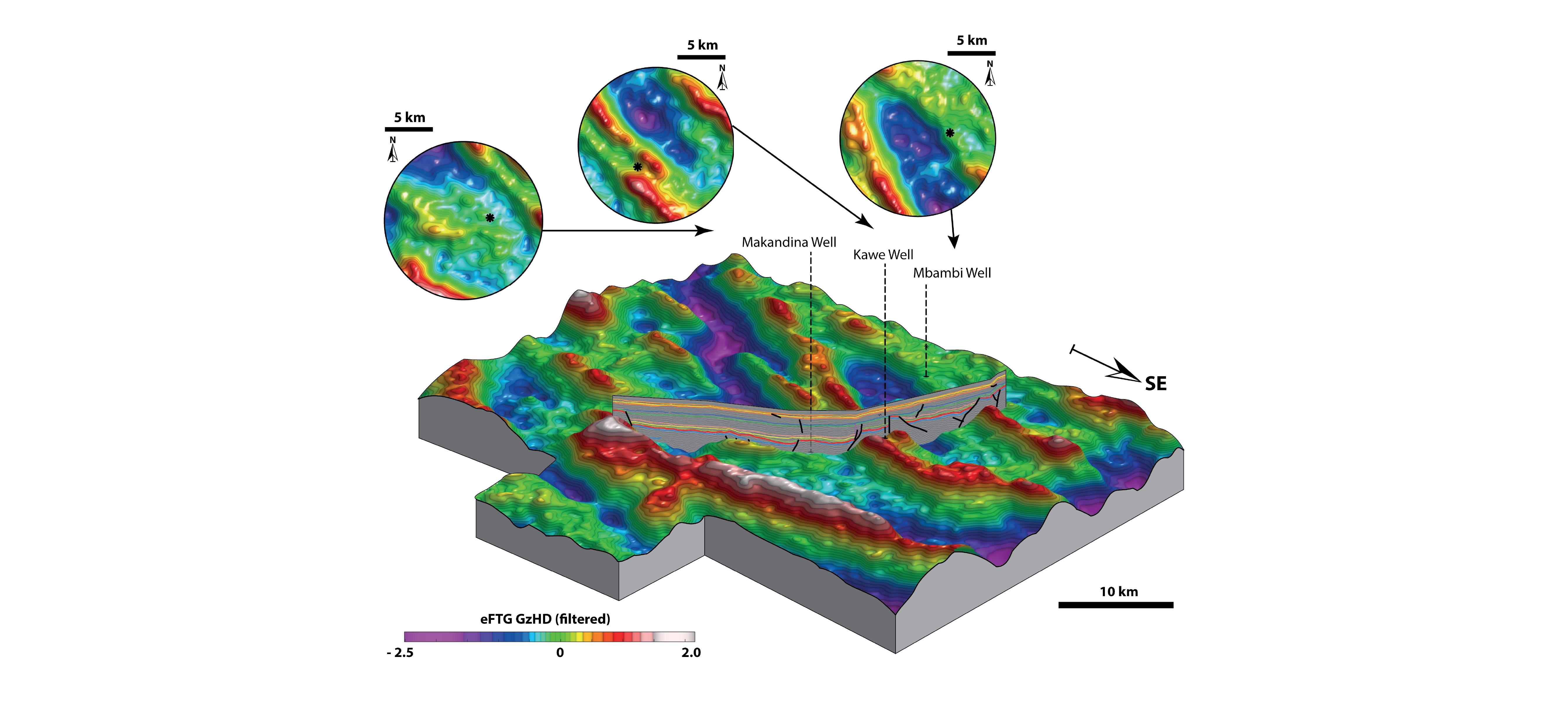
For example, in late August 2024 the commencement of airborne acquisition of eFTG, gravity, magnetic and LiDAR data began. Covering over ~28,000 km2 of the Kwanza Basin, onshore Angola, 38,000 + line kilometers of data will be flown by the end of September. Coverage includes 23 onshore exploration blocks with limited legacy geophysical data coverage.
This survey was conducted in conjunction with the Agencia Nacional de Petroleo, Gas e Biocombustiveis to provide data on the geological structures, sedimentary basins and salt tectonics in the Kwanza Basin to enable the participating operators to fast-track their exploration effort and to provide a basin-wide dataset to launch new international onshore bid rounds for the region.
The eFTG datasets will allow detailed information to be gleaned in terms of the structural composition, subsurface trends and lineaments and impact of the broader regional geology over the survey area, as well as highly-detailed information, achieved by infill over individual licence blocks. The magnetic data acquired at the same time is crucial to understanding the distribution and variation of volcanic rocks. Of particular interest is the identification of sedimentary basins and basement structures and specifically, the new eFTG data prepares the groundwork for challenging seismic imaging of the sub-salt structure.
Country-wide perspectives on resources
These larger scale ‘national’ surveys allow governments and agencies to have a country-wide geophysical dataset which can be used for multiple purposes such as mineral, hydrocarbon and renewables exploration as well as providing data that can be used for environmental and infrastructure planning purposes. The data also allows the unification of well data and numerous geophysical data sets, such as 2D and 3D seismic data, which is usually present over quite limited areas.
In many African countries where data coverage is sparse, such as Angola where only 10 percent of the country’s land has been geophysically and geochemically surveyed, these larger surveys can be an extremely cost-effective way of kick-starting or rejuvenating much needed resource exploration.
It is quite common, especially in oil and gas exploration for companies to abandon exploration in a sedimentary basin after just a couple of unsuccessful wells and temporarily at least, assigning that area to ‘barren status’. Early exploration in Namibia provides such an example with that country now a thriving production and exploration hotspot.
In such cases where there is a lack of early success, host governments often require new data to encourage entrants with a fresh approach to the area. Or if a new licensing round is initiated, an up-to-date, unifying geophysical dataset can be the catalyst to encourage new participants and fresh thinking to a basin with great potential but limited subsurface information.