
 STRATA. William Smith’s Geological Maps. Foreword by Robert Macfarlane.Most British geologists should be aware of the importance and significance of William Smith (1769–1839). The son of an Oxfordshire village blacksmith, with little in the way of formal education, he singlehandedly went on to produce in 1815, the first, largely complete geological map of England, Wales, and ‘part’ of Scotland. Much more than a map, it was a comprehensive account of the stratigraphy, associated fossils and uses of each of the principal rock types of Britain.
A Beautifully Curated Volume
What most of us who have been lucky enough to have had a career in geology have not easily been able to do until now, is to see these maps collected together in an easy to access, albeit weighty, single volume. Partly a showcase of Smith’s remarkable body of work and partly a sumptuous ‘coffee table’ art book, it is a lovingly and beautifully curated volume. The reader will find it filled with all of Smith’s individual sheets which made up the 1815 map and a host of beautifully reproduced plates of fossils, cross-sections, engravings, as well as the individual geological county maps he created later in his career.
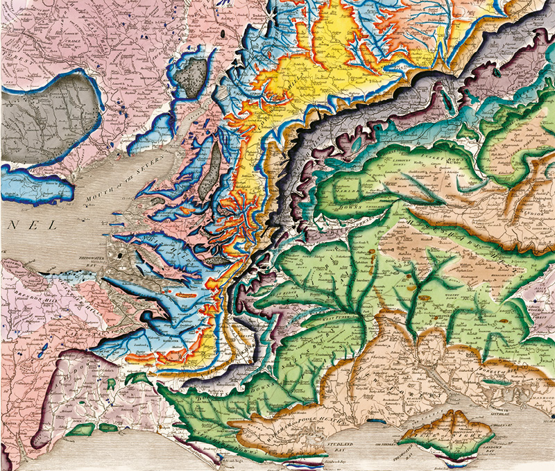
2 maps showing a Delineation of the Strata of England and Wales with part of Scotland. (William Smith, 1815. © University of Oxford, Museum of Natural History).
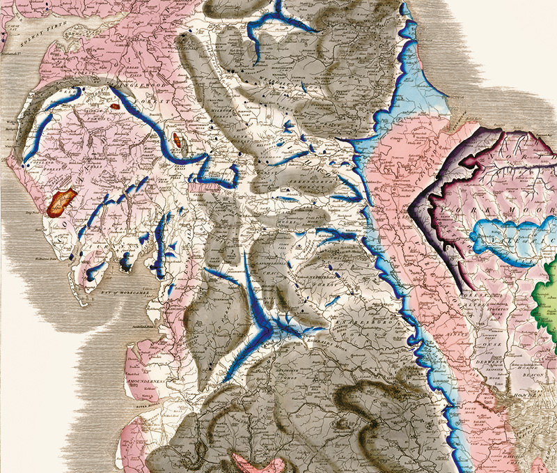
2 maps showing a Delineation of the Strata of England and Wales with part of Scotland. (William Smith, 1815. © University of Oxford, Museum of Natural History).
A Comprehensive Showcase of a Lifetime’s Work
The introduction to the book sets Smith’s work within the context of the geological theories and ideas of the time and then the volume is organised into four geographical sections, each represented by four sheets from the famous 1815 map. In each section the maps are beautifully accompanied by cross-sections and the appropriate county maps, as well as James Sowerby’s detailed fossil illustrations.
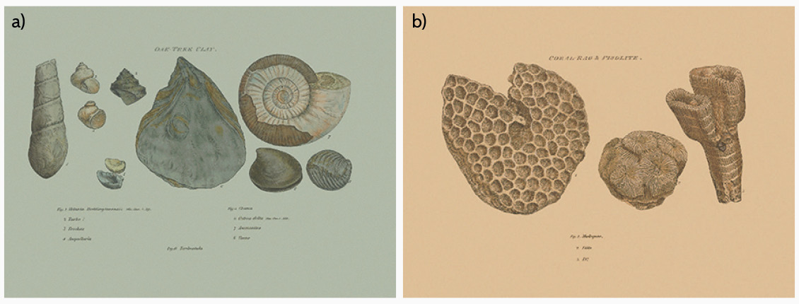
a) Fossils found in Oak Tree Clay; b) Fossils found in Coral Rag and Pisolite. (William Smith Printed by W. Arding, London 1816).
Between the various sections are accounts by prominent academics and experts, exploring the objectives and significance of Smith’s work and its impact and use in the fields of palaeontology, mining, stratigraphy, cartography and hydrology. Later in the book we learn about the rivalry with the establishment, in particular the then President of the Geological Society, George Greenough and his competing geological map, which was published after Smith’s in 1820. Smith’s incredible contribution to British geology was acknowledged in 1831 by the Geological Society when he became the recipient of the first Wollaston Medal in recognition of his achievements, and the influence of his geological mapping and biostratigraphical theories on the sciences, culminating in the establishment of the modern geological timescale.
811 Stunningly Coloured Maps and Illustrations
Now to the tricky business of price. This book is not inexpensive, retailing at around £50. Is it worth this outlay? I can only say yes, every penny. This is one of the most beautifully designed and illustrated ‘scientific’ books I have ever seen. It is a large volume at 27 × 2.8 × 37 cm, but this seems to me the perfect size to showcase the 811 beautifully coloured maps and illustrations. You do not have to be a geoscientist to enjoy and benefit from this volume; any lover of beautiful books and maps will appreciate it.
The ‘Timeline of Events in the Life of William Smith’, on page 19, concludes in 1839 with William Smith’s unexpected death in Northampton due to a chill caught while travelling to a scientific meeting in Birmingham. He is buried in the churchyard of St Peter’s church, Northampton. As a county resident, I think I will be taking a trip there soon to pay my respects to this icon of British earth science.


