West of Shetland: improved sub–basalt imaging
Newly reprocessed long offset seismic data from the Faroe Shetland Basin now provides a tool to enable interpreters to produce meaningful correlation in the sub-basalt section and raises some exciting geological questions for the West of Shetlands.
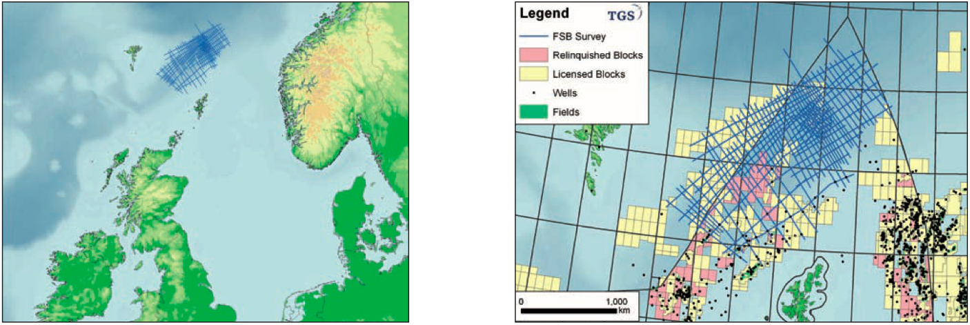
TGS has successfully completed the reprocessing of the first 6,500 km of a large 10,000 km long offset regional dataset in the Faroe Shetland Basin (FSB). The remaining 3,500 km is due to be finalised by February 2010. The objective of the reprocessing was to improve overall imaging with particular emphasis on the sub–basalt section.
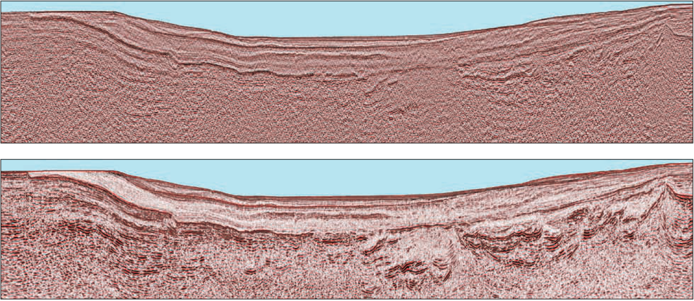
The foldout profile heading this article shows an example of the sub–basalt imaging achieved by methodical analytical processing using TGS’ latest processing software.
To observe the dramatic improvements achieved in the 2010 reprocessed data, a comparison between the original processing and the newly processed profile is shown. The recent reprocessing has brought out significant improvements of key importance in the understanding of the sub–basalt geological setting, allowing meaningful correlation across the West of Shetlands area.
Geological discussion
This summary, built on past and current exploration ideas highlights some new geological questions for the West of Shetlands.
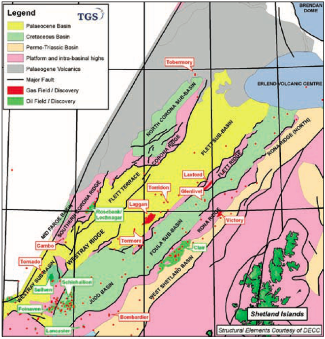
Looking at the West Shetland Basin area, the stratigraphic section known to be present in this basin consists of a full column of Tertiary section overlaying an Upper Cretaceous section resting unconformably on the Lewisian basement.
Moving northwest the profile traverses the Rona Ridge. The Clair oilfield further south is hosted on the Rona Ridge complex, with oil accumulated in a Devonian Sandstone reservoir overlain by a Carboniferous formation. This gives an indication of what might be present within the Rona Ridge in the Victory area. None of the wells drilled in the Clair area penetrated into basement. The overburden section deposited on top of the apex of the Rona Ridge consists of a nearly full Tertiary section with a late Palaeocene formation resting on the ridge apex.
The sediment section thickens dramatically immediately west of the Rona Ridge into the Foula Sub–basin. Deep seismic imaging is observed in the basin. Note the rollover feature observed in the Palaeocene section right next to the ridge – a possibly similar feature to the recent gas discovery Glenlivet. Good control on the anticipated stratigraphic column within the basin is provided, based on data available from wells drilled further south.
A near full Tertiary section rests unconformably on Late Cretaceous and Late Early Cretaceous. A hiatus unconformi- ty separates the Cretaceous from an underlying Late Jurassic section which is known to contain the Kimmeridge source rock. Several prospective sandstone reservoirs are present within the Cretaceous–Jurassic section. The Jurassic rests unconformably on Permo–Triassic, potential Carbonifereous (another possible source ) and Devonian section.
West of the Foula Sub-basin the FSB Profile crosses into the Flett Ridge area. The seismic data hints at the Flett Ridge being a composition of fault blocks forming the ridge caused by transpressural/transtensional movements within the fault block components. The stratigraphic composition within each of these fault blocks has hitherto been unknown.
Further to the west the profile traverses the Flett Sub–basin where compressional features within the Early Palaeocene section are evident. Within this area it seems possible to cor- relate a deep reflection sequence representing a Devonian/ Lewisian basement horizon across to the Rona Ridge area.
To the northwest the profile traverses the very interesting Corona Ridge feature containing a section imaged down to great depth. Could the Corona Ridge be formed of a set of fault block elements which as a whole constitute an inverted basin?
The Rona, Flett and Corona Ridge features all trend in the mainly NE/SW direction through this area each of them showing offsets caused by movements along the NW/SE transfer fault system active along the whole of the Atlantic Margin.
Northwest of the Corona Ridge the profile traverses a feature named the North Corona Sub–basin. It is founded on a set of fault block elements. It is possible to correlate reflec- tor horizons across the basin even at depth. The Eriboll well 213/23–1 drilled to the southwest of the profile encountered a carboniferous section underlying a Tertiary–Mesozoic section however the knowledge of the stratigraphic section within this sub-basin is still incomplete. Note the anticline feature at depth located within the area named the Faroe High.
The profile traverses further into the Faroese Continental Shelf (CS) across the Faroe–Shetland Escarpment and on to an area where the sub-basalt section rises dramatically to a position with the top volcanic horizon near the water bottom. Further observe the dramatic thickening of the individual basalt sequences into the Faroese CS and the much improved resolution achieved within the basalt sequences particularly in the shallow, where seismic sequence analysis now seems to be possible. Looking at depth in this section the immediate impression is that one is looking at a major set of fault blocks initially positioned at depth, but then from late Palaeocene/ Early Eocene to present was subjected to severe compression mainly in a WNW – ESE direction.
Reprocessing discussion
What were the main processing elements which led to this improvement?
Three key approaches were used:
- Preservation and enhancement of low frequency signal • Noise Attenuation in multiple domains
- Full Sequence Migration Velocity Analysis
Careful attention to the preservation and enhancement of low frequency signal, multiple and noise removal are seen to be crucial to improving signal-to-noise beneath the basalt. There is no need to compromise the frequency content of the overlying Tertiary section when reprocessing shallow towed datasets for sub-basalt targets.
The third approach, Full Sequence Migration Velocity Analysis, is seen to be the key to improving the structural interpretability of concealed Mesozoic and Palaeozoic structures. Recent advances in compute power mean that this procedure can now be run within the time frame of a quick turnaround large scale production project. It permits the early involvement of interpreters, to whom the choice of a range of alternative structural images may be presented. Each alternative has the processing and signal-to-noise characteristics of a final section and allows a ‘composite’ image to be built. The final time domain migration velocity field should provide an excellent reference model for initial passes of pre-stack depth migration and tomography-based velocity updates.
Conclusion
The West of Shetlands contains three of the largest producing fields on the UKCS today yet it still has vast tracts of open acreage. It is clear that this reprocessed dataset now gives the interpreter the ability to carry out evaluation, correlation and mapping within the prospective sub–basalt interval.