Join us as GEO ExPro Editor in Chief, Jane Whaley, takes us on a world tour of geological splendour and highlights seven geological wonders of the world that she has visited on her travels.
Opening Remarks from GEO ExPro Editor in Chief
I have been lucky enough to travel to many wonderful places in the world – although there are many more I have yet to visit – so here are some of my favourite geological sites. These are not in any particular order of preference – and of course, there are lots of others that could have featured here. In fact, it was very hard to whittle it down to just seven, I kept changing my mind what to include. Several wonderful places, such as the Azores, the Giants Causeway in Northern Ireland, Siguriya in Sri Lanka and Macchu Picchu didn’t make the cut in the end.….so many places to choose from.
Call Out to Our Readers
What would you put on your list? It could be a whole country, or just one tiny outcrop, but you must have visited it yourself. We’d love to hear about your different choices. What a wonderful world we live in!
Over the next few months we will collate all submissions to form a ‘Our Readers Seven Geological Wonders’ article. Please share your top locations with us via email or our social media channels for the chance to have your photos and recommendations featured and credited in the final article. There is even a chance that the final article will make it into one of the printed editions in 2019. For all submissions – see end of the article.
My Seven Geological Wonders of the World
Based on a combination of beautiful scenery and fascinating geology, my top seven geotourism locations across the globe, in no particular order, are:
Iceland
Tanzania: Ngorongoro Crater
Greece: Milos Island
Oman: Saiq Plateau
USA: The Grand Canyon
Egypt: The White Desert
USA: Yosemite
For further reading on each location, check out the list of recommended articles published by GEO ExPro at the end of this article.
Iceland
The majestic fjords of north-west Iceland, where seals play on the rocks and whales float serenely past. © Jane Whaley.
Because Iceland lies on the mid-Atlantic ridge you can stand with one foot on the European tectonic plate and one on the American continent – which has to be a bit of a thrill to any geology geek. It is one of the youngest landmasses in the world and is dominated by volcanoes, both active and extinct, which have created much of the island. From the cliffs and fjords of the coast to the volcanic moonscape and the ice fields of the interior, Iceland is a scenic wonderland dotted with dramatic waterfalls, lakes and rivers. There are geysers (the word itself is Icelandic) and hot springs; basalt columns and towering mountains; glaciers calving dramatically into vivid blue lakes and forming ice caves – and depending what time of year you visit, the Midnight Sun and the Northern Lights.
Even if you only manage to see the ‘Golden Triangle’ of Þingvellir National Park, where the continents are visibly splitting apart, the Geysir Geothermal area and Gullfoss waterfall – easily done in a weekend – you will have seen some geological wonders – but I recommend a longer trip to really get a taste of this unique island.
I could not choose a favourite spot, so the whole island of Iceland is in my list.
The author for scale against massive basalt columns on the south coast near Vik. © Jane Whaley.
The awe-inspiring waterfalls at Gullfoss flow through a canyon believed to have been created when a volcanic eruption occurred beneath an active glacier, creating a massive flood. © Jane Whaley.
The midnight sun catches the snow on the mountains. © Jane Whaley.
Tanzania: Ngorongoro Crater
© Jane Whaley
The African Rift Valley, visible from space, has to be one of the largest geological wonders in the world, representing the area where the African plate, which makes up most of Africa, and the Somalian plate to its east are pulling apart. This process involves huge volcanic eruptions, creating floods of lava and leaving behind the remnants of volcanoes – and results in plenty of spectacularly beautiful places to gaze at along its length, including the famous Ngorongoro Crater, the world’s largest caldera.
Most people visiting Ngorogoro are there in search of ‘The Big Five’ animals which have found shelter in this isolated valley, but even the least geologically-minded person cannot help but notice that that it is circular. Not a great leap from there to recognise the caldera of an extinct volcano, which formed between 2.1 and 2.8 million years ago when a tremendous eruption emptied the magma chamber, leaving the side of the volcano as a rim around a flat-bottomed area about 600m deep and covering an area of 260 km2. The unusual aspect of this volcano is that the rim remained intact, rather than knocked through by lava flows, leaving a miniature African wildlife world where thousands of animals co-exist in ecological harmony in a varied landscape of savannah, marsh, lake, salt pan, forest and escarpment, with enough food and water to sustain them year-round.
As discussed in more detail here (Northern Tanzania; A Truly Magical Place), when you have seen and photographed lots of animals, there are plenty of interesting geological features in the surrounding area, including Oldoinyo Lengai, Earth’s only active carbonatite volcano, the salt and sodium-rich Lakes Eyasi and Natron, and the crater highlands with both active and extinct volcanoes.
Looking down into the crater.© Jane Whaley.
A contained ecosystem. © Jane Whaley.
Shuttle Radar Topography Mission (SRTM), image of the Ngorongoro area looking south over the Crater Highlands and Ngorongoro to Lake Eyasi. Credit: NASA/JPL/NGA © Jane Whaley.
Greece: Milos
© Jane Whaley
All of the Greek Islands are worth visiting, for their beautiful beaches, charming headlands and startlingly blue sea and sky – not forgetting the food and drink, of course – as well as for some interesting geology. Horseshoe-shaped Santorini, for example, with its huge caldera forming an island-rimmed bay with a small central cone, looks to even the least geologically knowledgeable to be the remnants of a volcano. By comparison, the island of Naxos is dominated by a Mesozoic carbonate/detrital succession that has been deformed and metamorphosed in the orogenic collision between the African and Eurasian plates, converting the carbonates into the beautiful marbles used in building Delphi and other ancient Greek monuments.
One of my favourites is the rather younger and less well known island of Milos, also horseshoe-shaped and formed almost entirely from relatively recent volcanic material – although in this case the central bay is not a caldera but the result of faulting and erosion. There are two extinct volcanic cones to explore, which dominate the scenery, as well as the remnants of two crater rims. The stunning white cliffs and rock formations of Sarakiniko are formed of thick beds of ash deposited in a submarine environment in the Early Pleistocene. Fine examples of sedimentary features such as slumping and faulting can be seen in miniature in these layers – but bring strong sunglasses, because the white rocks in the bright Greek sunlight glinting off the sea can be very dazzling.
There are also vivid examples of mineral alteration due to the escape of hydrogen sulphide-rich gases from the underlying volcanic material, as can be seen in smoking fumeroles in the southern part of the island. In this area the cliffs are streaked with bright pinks, reds and oranges as a result of mineral alteration.
The volcanic processes have also produced a range of rare metals and minerals which are mined and quarried throughout Milos. These include clays such as bentonite and perlite (Milos is the world’s most important source of this material) as well as manganese, silver and lead.
Much of the western part of the island is not accessible by vehicle, so it is also a wonderful place to enjoy uncrowded hiking with fabulous views.
The white rocks of Sarakiniko, formed from volcanic ash. © Jane Whaley.
Rocks altered by escaping gases. © Jane Whaley.
Basalt intruded into layers of volcanic ash. © Jane Whaley.
Sequences of ash deposition, both sub-aerial and marine, are clearly seen in the cliff faces. © Jane Whaley.
Oman: Saiq Plateau
© Jane Whaley
The once impregnable Saiq (or Sirq) Plateau is part of the great limestone massif of Jebel Akhdar in the Al Hajar Mountains in northern Oman. The almost sheer cliffs drop about 2,000m into the dramatic Wadi al Ayn on the southern edge, with craggy mountains to the north, and in the west the highest point in Oman, Jebel Shams, rises up a further 1,000m above it. For centuries the only way to reach the plateau was an exhausting six-hour hike up an almost vertical mule path, which explains how forces rebelling against the Sultan of Oman managed to hole up there for several years in the 1950s. Although a paved road had been built late in the 20th century, until 2005 the plateau was a military zone and visitors were not encouraged.
Now, however, it is possible to drive the hairpin bends up the single road to this peaceful plateau, which is predominantly composed of late Permian dolomite and limestone. This has undergone extensive karstification, resulting in caves and sinkholes and also tufa deposits, caused by the rapid precipitation of calcium carbonate, which in places falls over the cliff edge like a petrified waterfall. There are many fossils in the rock, especially corals.
The Saiq Plateau has the highest rainfall in Oman and its height means that it has a considerably more temperate climate than that on the coastal plain around Muscat, about 90 km to the north-west. As a result, it is one of Oman’s most fertile regions, growing a range of fruit such as peaches and pomegranates, as well as walnuts, almonds and damask roses, which are used to make the famous Omani rosewater. These do not grow on the arid flat limestone plateau surface, but in narrow terraced fields which cling precariously to the contours of the steep wadi sides, watered through a sophisticated system of irrigation channels.
Agriculatural terraces carved into the cliff below the village of Al Ayn. © Jane Whaley.
Wadi Al Ayn viewed from the plateau. © Jane Whaley.
The deserted village of Wadi Bani Habib. © Jane Whaley.
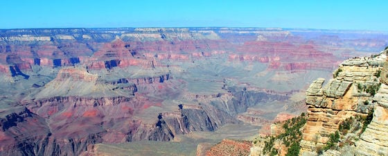
Grand Canyon
© Jane Whaley
Yes, it is the ‘poster boy’ for geology – but nothing can take away from the fact the Grand Canyon is the most astonishingly vast view of geology and geological processes at work in the world. Probably more photographed than any other rocks on earth, the actual size of the Canyon – over 400 km long, up to 29 km wide in places and nearly 2 km deep – still comes as a breath-taking surprise to the new visitor. It is literally possible to stand and look at this amazing place for hours on end, especially as the sun rises or sets, finding new crevices, rocks, and pinnacles as the colours change with the sun. It truly is a wonder of the world.
The canyon’s depth represents nearly 2 billion years of geological history, one of the most complete sections on earth. Revealed at the base is crystallised basement gneiss and schist from the Late Precambrian, noticeably darker than the overlying sediments and not horizontally bedded as they are. They have undergone uplift and extensive erosion. Above these are up to 1,500m of layered Palaeozoic sandstone, shale and limestone layers, predominantly deposited in warm shallow seas, near-shore environments and swamps as the sea repeatedly advanced and retreated along the edge of a proto-North America. It is believed these were once covered by great thicknesses of Mesozoic sediments, none of which remain. Other than a few Cenozoic lake deposits, the only young sediments are lava flows and cinder cones resulting from volcanic activity which began about six million years ago and continued to within the last several thousand years.
The area was uplifted about 65 million years ago at the end of the Mesozoic era, but the canyon itself is a late Cenozoic feature, the result of the snow-fed Colorado River cutting down through the layers, although there is some debate about this timing, some claiming it to be much older. The arid climate limited widening, resulting in the unique depth and steepness of the Canyon sides.
The Grand Canyon is also a great place for an education in geology, and the park authorities have done an excellent job of this, with a small, well explained and presented geological museum and a ‘Trail of Time’: a 4.56 km long trail, with every metre representing 1 million years of the earth’s geological history.
Looking at 2 billion years of the earth’s history. © Jane Whaley.
The canyon is up to 29 km wide. © Jane Whaley.
Astounding views in all directions: the sheer scale of the Canyon never ceases to astonish. © Jane Whaley.
Experiencing a bucket shop dream – hiking into the canyon. © Jane Whaley.
Egypt: The White Desert
© Anne Whaley Sousou.
When it was suggested that we went on a 5-day camping trip in the Egyptian Western Desert, a bit of me thought “Hmm. I wonder if that might be a bit boring?” How wrong I was! There is so much to see in the desert!
First stop was the classic oasis town of Bahariya, a true splash of welcome green after a 370 km drive from Cairo through flat, stoney desert. Moving south from there the next feature of note is the accurately named Black Desert; not particularly pretty, with black-topped conical hills looking remarkably like slag heaps, but interesting nonetheless. The hills are composed of Cenomanian red iron-rich sandstone and chalky clays, mostly capped with basalt sills, with black sheets of gravels and rock fragments strewn on the desert floor. Fossilised remains of Late Cretaceous dinosaurs have also been found in this area.
A little further south is ‘Crystal Mountain’ – not actually a mountain, but a cave which had hydrothermally filled with calcite crystals and then collapsed due to karstification, leaving only the cave entrance as a natural rocky arch. In the area you can also pick up stones and fossilised coral which have been turned into haematite by leaching iron.
About 80 km south of Bahariya is the truly spectacular White Desert. This 3,000 km2 area, classified by Egypt as a natural protected zone, is dominated by white chalkey limestone outcrops which have been carved by wind-born sand over millions of years into fantastic mushroom shapes. To stay a night in this majestic, eerie and silent landscape and watch the star-studded night sky give way to the sun as it slowly turn the silhouettes of these giant shapes pink and then dazzlingly white is truly a unique experience.
That’s quite some campsite. © Anne Whaley Sousou.
The White Desert. © Anne Whaley Sousou.
The Black Desert. © Anne Whaley Sousou.
The crystal arch. © Anne Whaley Sousou.
USA: Yosemite
The whole of the Rocky Mountain Range is full of geological wonders, but I’ve plumped for the Yosemite Valley, because it includes some of the most iconic geological features in the world, including the sheer cliff face of El Capitan, a Mecca for climbers from all over the world.
Geologically, the Sierra Nevada, where Yosemite is situated, is a huge block of the Earth’s crust that has broken free on the east along a bounding fault system and been uplifted and tilted westward, a process which is still ongoing. A series of huge granite intrusions have resulted in some of the most memorable features of the park, including Half Dome, Sentinel Rock and El Capitan itself. The emplacement of these intrusions began in the late Triassic and continued for about 130 Ma, so a wide variety of different granitic features and compositions are found in the area, with dykes cutting through the older intrusions, as can be seen on the face of El Capitan.
Some metamorphic rocks are also present, especially along the western edge of the park and in the summit area. These are remnants of ancient sedimentary and volcanic rocks that were deformed and metamorphosed in part by the invading granitic intrusions. The rocks which once covered the magmatic intrusions as they cooled into granite have for the most part been eroded away, however.
Uplift of this granitic core began about 25 Ma, eventually leading to the high mountains we see today, which have been dissected by many streams and rivers, as well as by glaciers and glacial melt in the colder periods of the last few million years. The Yosemite Valley itself was shaped by glaciers, following the original V-shaped canyon carved by rivers. Several of the major features in the Yosemite National Park are classic ‘roche moutonnées’, characterised by a smooth, rounded side where the glacier flowed over it and a steep face where the glacier flowed away from it, pulling rock away along joint planes.
At about 87 million years old, the granodiorite which makes up Half Dome is the youngest plutonic rock in the valley area. Credit: Diliff, via Wikimedia Commons. © Jane Whaley.
Yosemite Valley has the classic glacial U-shape. © Jane Whaley.
Fantastic granite rock shapes. © Jane Whaley.
Further Reading on World Famous Geological Locations
Iceland
Lakagigar. Catastrophe & Climate Change
Iceland. Harnessing the Earth
Exploring the Icelandic Frontiers
Getting Into Hot Water: The Blue Lagoon
Tanzania: Ngorongoro Crater
The East African Rift System – A View from Space
Oil and Gas Exploration in East Africa: A Brief History
Exploration in the East African Rift System
Greece: Milos
Sun, Sea, and Sarakiniko
A Fresh Look at the Oil and Gas Potential of Greece
Miloterranean Geo Experience
Oman: Saiq Plateau
The Best Geological Site in the Middle East
The Search for Oil in Oman
Grand Canyon
Hiking through the Palaeozoic
Egypt: The White Desert
Egypt’s Secret Treasure
The Great Sphinx of Egypt: Nature’s Shabby-Chic Trick?
Tell us about your own geological wonders…
Please contact our Digital Editor, Nathan Young-Ziolkowski on nathan.young@geoexpro.com
You can also share your top locations and a picture on our social channels:
Facebook
LinkedIn GEO ExPro Group
Twitter
#geologicalwonders #geoexpro
* Please only share photos your have permission to share and credit the owner accordingly. We will only features photos we can obtain the right to show. Please do not submit stock imagery from public domain image sites.
About the Author…
Jane Whaley
Editor in Chief | GEO ExPro Magazine
A geologist with 30 years experience in the oil industry, ranging from high resolution seismic surveys to technical studies with IHS, Jane has been involved with GEO ExPro Magazine since 2005. Previously Associate Editor, Europe and Africa, she has been Editor in Chief since 2010.