Bridging proven plays and frontier potential
The offshore of the Caribbean has experienced a dramatic and enduring tectonic history full of movement and continuous accommodation. Forming in the Late Cretaceous in the Eastern Pacific, the Caribbean plate began to migrate eastward relative to the North and South American plates behind an east-facing Great Arc of the Caribbean to its present position. As a result of this eastward shift, a series of strike-slip faults were generated to accommodate such a dramatic landscape change, most notably the San Sebastian and El Pilar faults. Constraining the timing of these events is pivotal to the understanding of the petroleum systems for trap formation and thermal history.
Time to find some perl(a)s
As expected, the location of predominant deposition similarly shifted throughout the tectonic history of the region. The Orinoco River deposited large quantities of sediment into the offshore, migrating through geologic time across the top of Northern South America to the present-day point of deposition towards the East of the paleo depositional locations.
This river system was key to the reservoir development, which is plentiful in numerous locations offshore, particularly the Orinoco delta, and the La Luna source rock, which is prolific across the region, generating significant quantities of hydrocarbons.
The time equivalent interval to La Luna in Trinidad, known as the Naparima Hill formation, has also generated significant quantities of hydrocarbons. The exploited fields, such as Mejillones, Patao, Dragon and Hibiscus, have provided significant volumes with prospectivity further affirmed by discoveries to the south of Trinidad, including Manatee/Loran and Makain/Cocuina.
This further indicates an extended working petroleum system and proves that large accumulations are found in multiple settings. bp has recently confirmed a positive FID to develop these fields, supporting the development potential.
Utilising developments associated with this FID will also increase exploration upside and viability by using the new reprocessed seismic data sets to extend exploration from the proven producing areas to the frontier.
Excellent reprocessing leads to increased trust
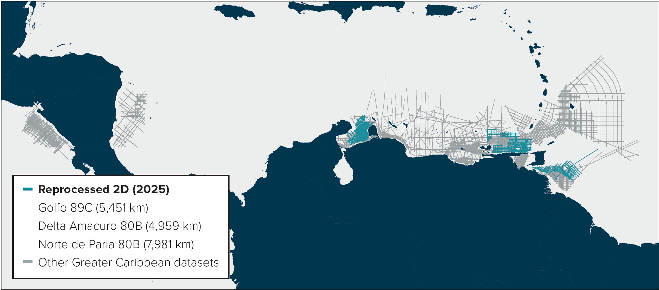
In order to further explore these frontier regions, several surveys have been reprocessed by Geoex MCG and DUG Technology in the aforementioned regions, which are strategically placed to tie these existing discoveries within a frontier environment.
The works undertaken predominantly focused on improving the overall subsurface imaging using more advanced reprocessing workflows. By completing steps such as DUG’s Broad deghosting, several multiple elimination algorithms, amplitude Q compensation and anisotropic pre-stack depth migration, the overall image is far superior to the legacy data.
This has elucidated the deeper section and provides confidence in the amplitude fidelity that previously did not exist with the legacy information. Furthermore, the data is also available in the Pre-Stack Depth domain, which provides an accurate understanding of the depth to target with further angle stack and gather information available to allow interpreters to complete AVO analysis.
Deserves a standing (av)ovation
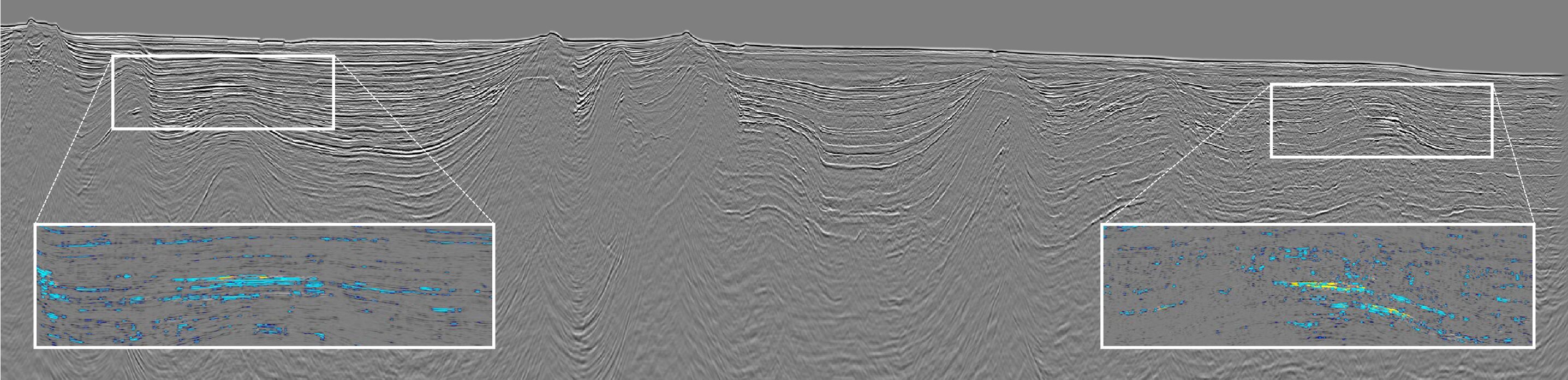
Following this improvement, identifying the fields and exploring for self-similar structures serves as a useful proxy to possible further discoveries in frontier areas. Moreover, any observable DHI’s that show similarity to the fields can, in theory, be used to de-risk structures in a frontier area, providing a more attractive prospect.
Although the debate regarding their validity is often had, these features provide an indication of encouraging prospectivity, and therefore it is argued that their presence, rather than their absence, provides an advantage. Data sets that traverse fields as well as frontier areas allow the geoscientist to confidently extrapolate seismic interpretations away from existing fields to identify self-similar structures, reducing the uncertainty around exploration.
As shown in the seismic section (fold-out), self-similar undrilled structures exist to the south of producing areas. These areas show a similar display, AVO signature, and a similar size and geometry to that of the discovered fields. Whilst further investigation is required to further de-risk this type of feature, the evidence is overwhelming to suggest that similar hydrocarbon volumes could be found in what would be a similar depositional environment.
BSRS South of Trinidad
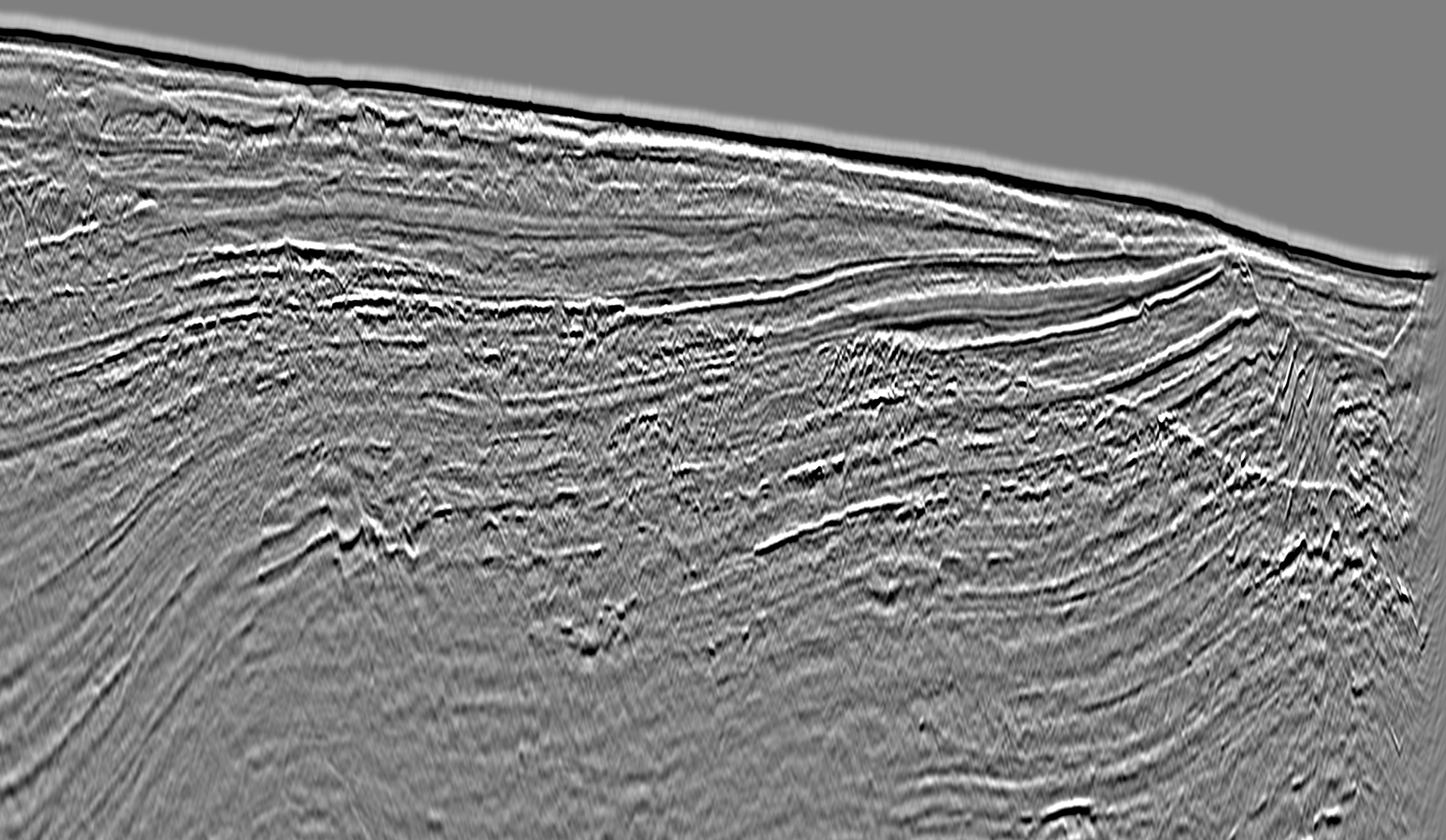
A further feature that has been widely observed in the seismic data to the south of Trinidad is a Bottom Simulated Reflector (BSR). These features, as shown in Figure 1, crosscut existing sedimentary strata and run parallel to the seabed but have a reversed polarity. This effect is caused by the negative acoustic impedance contrast between sediments containing gas hydrate and free gas underneath the gas hydrate stability zone. As this is present within the data, it provides encouragement regarding the likelihood of exploration success.
A ‘seismic’ shift in depositional trends
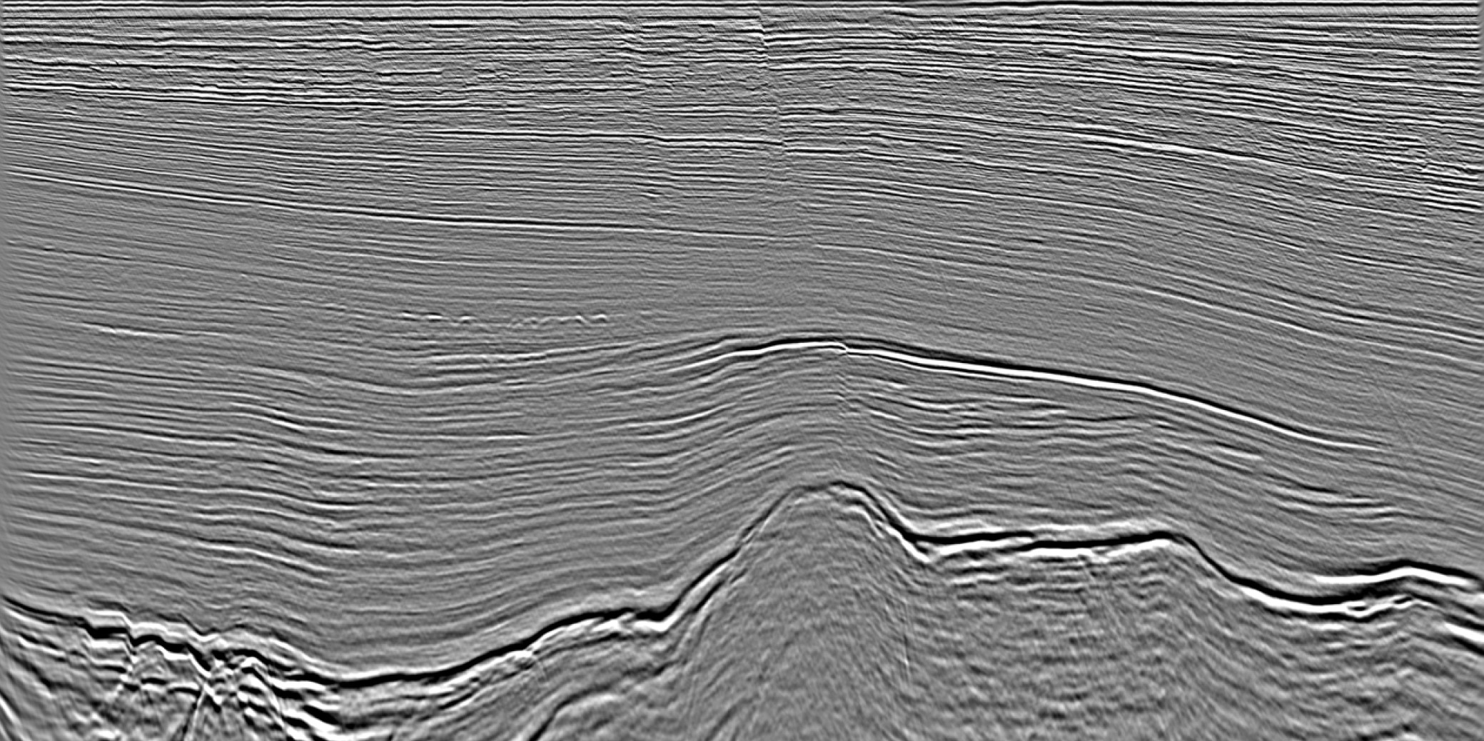
Whilst the La Luna equivalent source rock provides excellent volumes of hydrocarbons across the region and likely in the frontier areas, a secondary petroleum system exists that also produces significant quantities of gas. Discovered in 2009, the Perla discovery was made in Oligo-Miocene (Chattian to Aquitanian) carbonates categorised by porosities of ~ 20 %. Whilst this particular discovery is not shown in this article, a self-similar structure is displayed in Figure 2. The difference between the two is the lack of faulting throughout the structure of the second example, although the overall geometry and size remain the same. Geoex MCG will continue to map the depositional environments in these areas to better constrain and understand the possibility of a significant accumulation in this region.
A third survey, imminently finalising, is located in the Norte de Paria region. Here, the main discoveries are clearly highlighted on the data as well as significant areas of frontier acreage that will be similarly analysed.
The truth is in the drill bit
Like all methodologies in exploration, the aim is to de-risk and provide further confidence that expected volumes will be encountered. The exploration debate regarding the usefulness of these types of DHI features continues. But despite these discussions, and not knowing until the drill bit is in the ground, these DHI’s provide encouragement that hydrocarbon fields are likely to exist in frontier environments.
In the context of the Greater Caribbean, we’ve seen that numerous bright amplitudes, flat-spots and self- similar structures to existing fields can be seen within a frontier gas environment. Whilst also providing information regarding potential oil and gas exploration locations, these newly reprocessed seismic surveys also help to further constrain the timing of key tectonic events, which would provide key information for a thorough basin synthesis.
Reprocessing has been concluded on all three of the surveys discussed in this article and is available for review.


