Messages from the past, written in gravity
In the 2014 Sci-fi blockbuster ‘Interstellar’, Cooper (Matthew McConaughey) has to save humanity whilst decoding messages from gravitational anomalies. (Spoiler alert: this involves heading into space and the ensuing hi-jinks.)
Back on earth a prequel to this adventure is happening today as geoscientists are using seismic images of gravitational collapse structures to time-travel and understand the development of hydrocarbon systems in the world’s passive margins.
Unique Basins and Global Datasets
The basins along the eastern and western margins of Africa and South America have a lot in common. They all started forming together as a super continent ripped apart, yet since that time these margins have been passive, slowly subsiding while being infilled by sediments washing off the surrounding continents. Curiously, however, in each basin the detailed development of the geology has been unique. While one might expect sediment supply to a basin to be heterogeneous (dependent on river system stability and climate in the drainage fetch), this uniqueness is also seen on a structural level. At any given time one basin may have suffered uplift with erosion whilst its neighbour underwent subsidence and instability. In these idiosyncratic details lie the keys to understanding the working of the hydrocarbon systems that make some basins prolific and others barren.
These secrets are being revealed as we acquire more modern long-streamer and long-record length, high frequency 2D seismic data on the world’s deepwater passive margins. Designed to track down hydrocarbons, first of all regional datasets are acquired that allow the basin to be mapped, its main characters captured and the hunt for source, reservoir and traps to commence. These regional datasets are then infilled with closer spaced seismic so that leads and prospects, potential traps for oil and gas, can be mapped in detail and risked. If the prize is significant, the acreage over these leads can be taken by exploration companies and the prospects drilled.
In the process of reducing risk however, new insights about an individual basin can be obtained, and if the dataset is big enough, those insights can be extended between and beyond basins. Many companies have sought to develop such a global dataset, including Spectrum, which has collected three million kilometres of long-offset modern seismic data in the world’s basins, both frontier and mature, making the company well placed to use this data to seek the a broader understanding.
Megaslides and Mantle Bumps
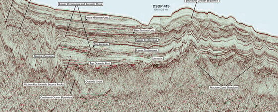
From this global dataset, one manifestation of basin development that appears to indicate that a single earth model might be attainable is the structural instability recorded in seismic data of the ‘Gravitational Megaslide’. These slowly formed, gravitationally driven collapse structures are relatively common in the clastic deltas of the Atlantic margins, and they are indeed ‘Mega’ because they can occur on an immense scale; tens of thousands of square kilometres of sediment sliding slowly into the Atlantic, forming a wide extensional belt up-dip and a compressional toe-trust and fold belt at the down dip-end, as shown in the figure below.
Megaslide example from Namibia.
These features are thought to form when thick sediment is deposited on a tilted organic rich layer which starts to generate hydrocarbons, increasing internal pore-pressure and weakening the layer so that it no longer supports the sediments on top of it. These then slide on a horizontal fault or decollement surface into the basin. The problem is that in some basins these slides have formed as expected – and yet in other similar basins they have not, irrespective of the presence of organic rich layers. Sometimes they form and then stop, unexpectedly. Their occurrence seemed just one more piece of mysterious basin uniqueness.
However, we can read the gravitational message captured in these geologies. This information on the timing of formation of megaslides is part of the study of basin stability that may be a route to unlocking a model that glues ‘basin uniqueness’ into one earth model. This could allow explorers to understand the connectedness between basins, and improve the predictive model for hydrocarbon system development. The one-earth model stems from the observation of large variations in the depth to the Earth’s mantle under oceanic crust (Hoggard et al, Nature Geoscience, 2016), caused by the pattern of mantle convection cells. This makes large, basin scale bumps on the top of the mantle that the overlying plates and their basins get dragged over , like ‘shoes on a rug’, as the plates move through geological time. The consequence of the irregular topography for a basin is subsidence and instability or uplift and stability, which is the record that we can read from the seismic (Hodgson and Rodriguez, First Break, March 2017).
Initial observations suggest the pattern of mantle bumps, and therefore the mantle convection cells, may stay fairly constant for long periods of time. Itself a surprise, this could give us the ability to take the map of mantle topology today and use it to predict basin behaviour in the past by back-tracking the movement paths of basins and plates. Unconformities and instabilities can be used to read the language of gravity in these seismic sections, allowing us to propose a new set of mechanisms for the formation of curious geological uniqueness in passive margin basins. The amount of sub-areal magmatism that occurred as the Atlantic Basin started to grow has been perplexing because it varies markedly along the margin. This can now be explained by the impact of the underlying surface of the mantle during and soon after the formation of the rift that ripped the super-continent apart, which also elucidates some of the irregularity or asymmetry in the basin between conjugate margins.
A Single Model?
Of course, the many other factors effecting the evolution of basin geology will still be valid. The development of thinking that focussed on the interaction of rising and falling global sea level with growing depositional sedimentary systems – sequence stratigraphy – was the greatest geological discover of the late 20th century, and the single most important new tool in the box for explorers as we move off the shelf and into deep water exploration domain. All that remains is the search for the glue that can hold the structural uniqueness of basin development into a single model, and perhaps this, with new seismic data to peer into the abyss of frontier geology, is now in sight.
To paraphrase Mr Cooper from Interstellar: “We’ve always defined ourselves by the ability to overcome the impossible. And we count these moments. These moments when we dare to aim higher, to break barriers, to reach for the unifying model, to make the unknown known. We count these moments as our proudest achievements. We are still pioneers, and we’ve barely begun, and our destiny lies beneath our feet.”
References
M.J. Hoggard et al. ‘Global dynamic topography observations reveal limited influence of large-scale mantle flow.’ Nature Geoscience 2016
Neil Hodgson and Karyna Rodriguez ‘Shelf stability and mantle convection on Africa’s passive margins (Part 1)’ First Break Vol 35, No 3, March 2017
Nolan, C., Nolan, J., Thomas, E., Obst, L. R., McConaughey, M., Hathaway, et al, ‘Interstellar.’ Warner Home Video (Firm),. 2015