Geological Setting
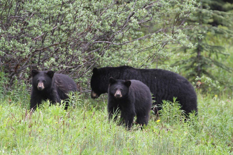 Mother and cubs near the Icefields Parkway – be sure to leave time for wildlife viewing! Source: Dave HargreavesThe Canadian Rocky Mountains rise majestically from the interior plains of Alberta. Let’s ponder the general geological setting of Canada. In a nutshell, where the central craton of the North American continent is exposed it is called the Canadian Shield, which occurs in northern Saskatchewan, Manitoba, Ontario, Quebec, Nunavut and the Northwest Territories. The gneiss underlying the Rockies as basement is of this same Archean age and is part of this craton. The shield area in the Archean was a mountainous uplifted area and shed sediments towards the future Interior Plains and future Rocky Mountain areas while at the same time lying in the southern hemisphere. At times underwater, most notably during the Cambrian when the famous Burgess Shale was deposited, and at times exposed, for example during the Silurian, the sediment layers built up with mostly shales and carbonates interlayered with some quartz sandstones and silt layers. Of economic importance today, during the Devonian a significant warm inland sea developed, creating reef deposits that later became viable oil- and gas-producing formations in Alberta. There is also evidence of glacial activity in the Proterozoic and Carboniferous as well as during the most recent cyclic Neogene and Quaternary glacial episodes.
The Canadian Rockies extend from the US border in the south, trending north-west for almost 1,500 km following the Alberta-British Columbia (BC) border, crossing into BC and terminating just shy of the Yukon Territory. It is a long, narrow range, 180 km wide at most, and was created by thrust faulting from west to east, when older Cambrian rocks were thrust up and over younger Mississippian and even Cretaceous rocks. The Rockies consist of the Foothills, the Front Ranges and the Main Ranges, and end abruptly at the Rocky Mountain Trench which lies just inside the BC border. The Trench, visible from space, came into being about 60 million years ago as a huge downward trending fault and has the youngest sediments in the Rocky Mountain area.
Thrust faults occur in fold and thrust belts which are associated with orogenies, or periods of mountain building due to collision of plates. In this area, the Rockies were raised due to collision with terranes to the west of the central craton which collided, causing thrust faults which propagated themselves laterally and upward through the section. By definition, thrust belt faults move upward through the section and always result in older rocks overlying younger ones. Movement is usually along weaker shales and the uplifted rocks are often the hard, resistant cliff-forming carbonates from the Cambrian thrust over soft clastics from the Mesozoic. Glaciation and water erosion deepened the less resistant shale-filled valleys. The fault lines trend south-east to north-west. Complex folding and faulting associated with the thrust faults include drag folds and break thrust faults, where the anticline-syncline pair rupture leaving steeply dipping formations in either direction and occasionally sometimes backwards.
The most recent glaciation in the area was the Wisconsinan, which brought the Cordilleran ice sheet from the mountain areas over the city of Calgary, where it lay probably 1 km thick, approximately 31,000–14,000 years ago.
Glaciers and Hikes
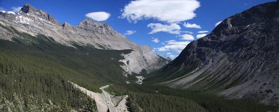
From this point we will travel back in time on our trip heading north-west along the Icefields Parkway towards Jasper. This beautiful highway follows the trace of the 330 km long Simpson Pass fault and the valley bottom, consisting mostly of shale, shaly limestone and gritstone of the Proterozoic Miette Group. The Icefields, or glaciers, high up on the watershed, feed valley glaciers and these are visible along the route. The Icefields themselves are supported by the hard resistant rock of the main ranges, the relatively flat thrust sheets of resistant Gog quartzite and the Middle Cambrian carbonates and dolomites such as the Cathedral, Stephen and Eldon Formations.
It is highly recommended to grab a copy of Ben Gadd’s Canadian Rockies Geology Road Tours for much greater detail than is offered in this article.
Follow the scenic Icefield Parkway northwards, from Lake Louise to Jasper
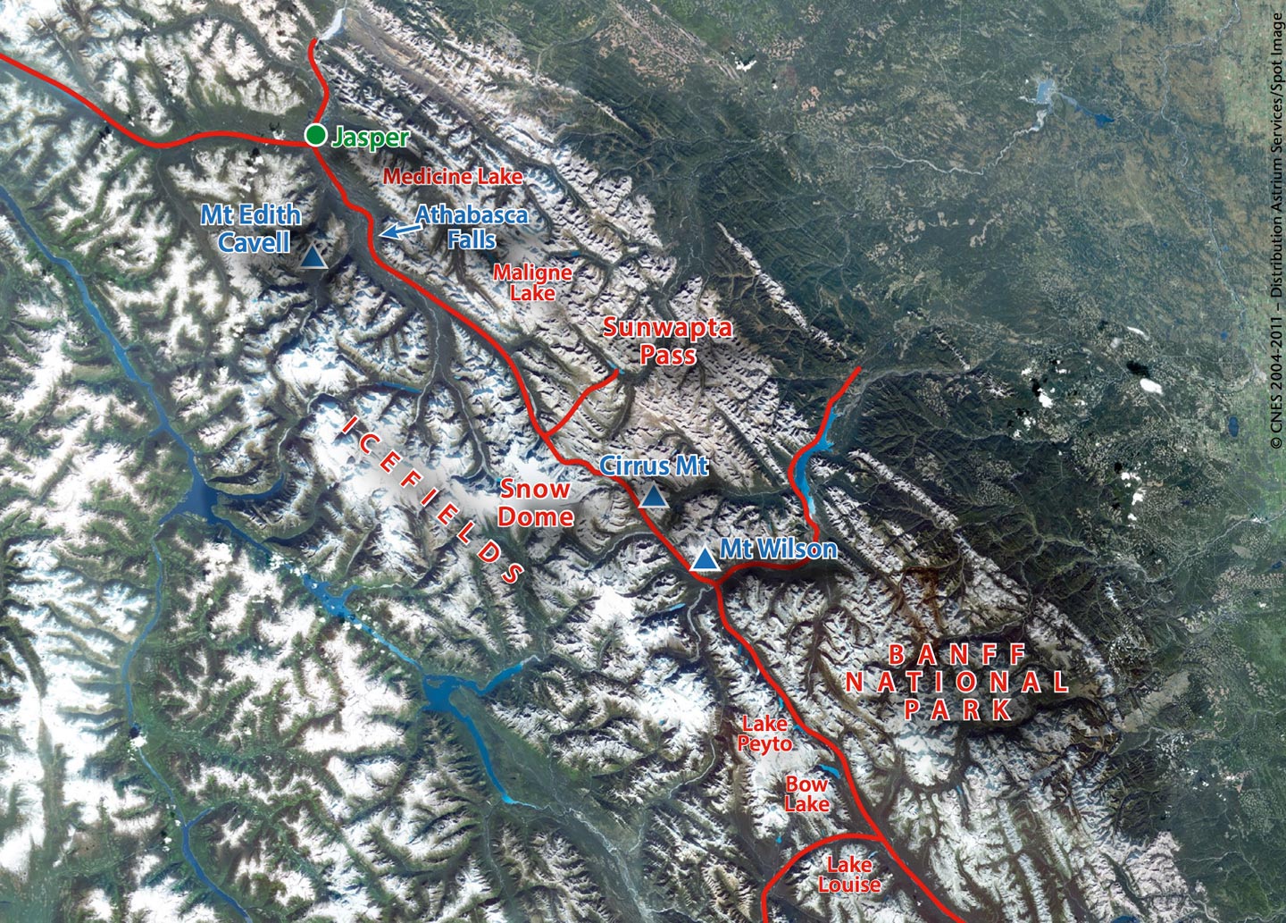
 3.4.5.6.7.8.9.
Source: © CNES 2004-2011 – Distribution Astrium Services/Spot Image
About the Author
 Anne Hargreaves has a B.Sc. in Geology from the University of Calgary. She has worked for over 20 years for several companies working with geological data and collections. Currently she is Vice-President of Canadian Stratigraphic Services (2000) Ltd, which is better known by the trade names of Canstrat and Amstrat, and which supplies well log descriptions from Canada and the US to the oil and gas industry.
References
- Eyles, N. and Miall, A., Canada Rocks, The Geologic Journey, Fitzhenry and Whiteside, 2007.
- Gadd, B., Canadian Rockies, Geology Road Tours, Corax Press, 2008.
- Hanus, C., Canada by Train, the Complete VIA Rail Travel Guide, Way of the Road Publishing, 2009.
- Patton, B, and Robinson, B, Canadian Rockies Trail Guide, 8th edition, Summerthought Publishing, Banff, 2011


