Evidence-based exploration on the slope of Nova Scotia
In his definitive book on the form, Robert McKee writes that a “Story” tells how characters navigate the restoration of balance to the world, when that balance has been disturbed. Similarly, imperfect and incomplete subsurface data can leave explorers perceiving source, seal and reservoir are also out of balance until new imaging, models and analysis arrive and our roles in these stories play out when we grasp, absorb and use the new data to construct a new order.
In the slope of the passive Nova Scotian margin lies some of the most interesting geology in the world, that we are only now beginning to image. Beneath a thick Cretaceous and Tertiary clastic sequence lies a Triassic and Jurassic syn-rift on extended continental crust that grades out-board to variable magma-rich and magma-poor transitional oceanic crust. Out of that syn-rift a huge volume of mobile salt has flowed reactively creating salt walls and diapirs, and in the early Tertiary this salt even spilled out on to the slope seabed creating a glacier of salt. Later, this salt itself got swamped and covered by large volumes of clastic deposits pouring off the Nova Scotian shelf.
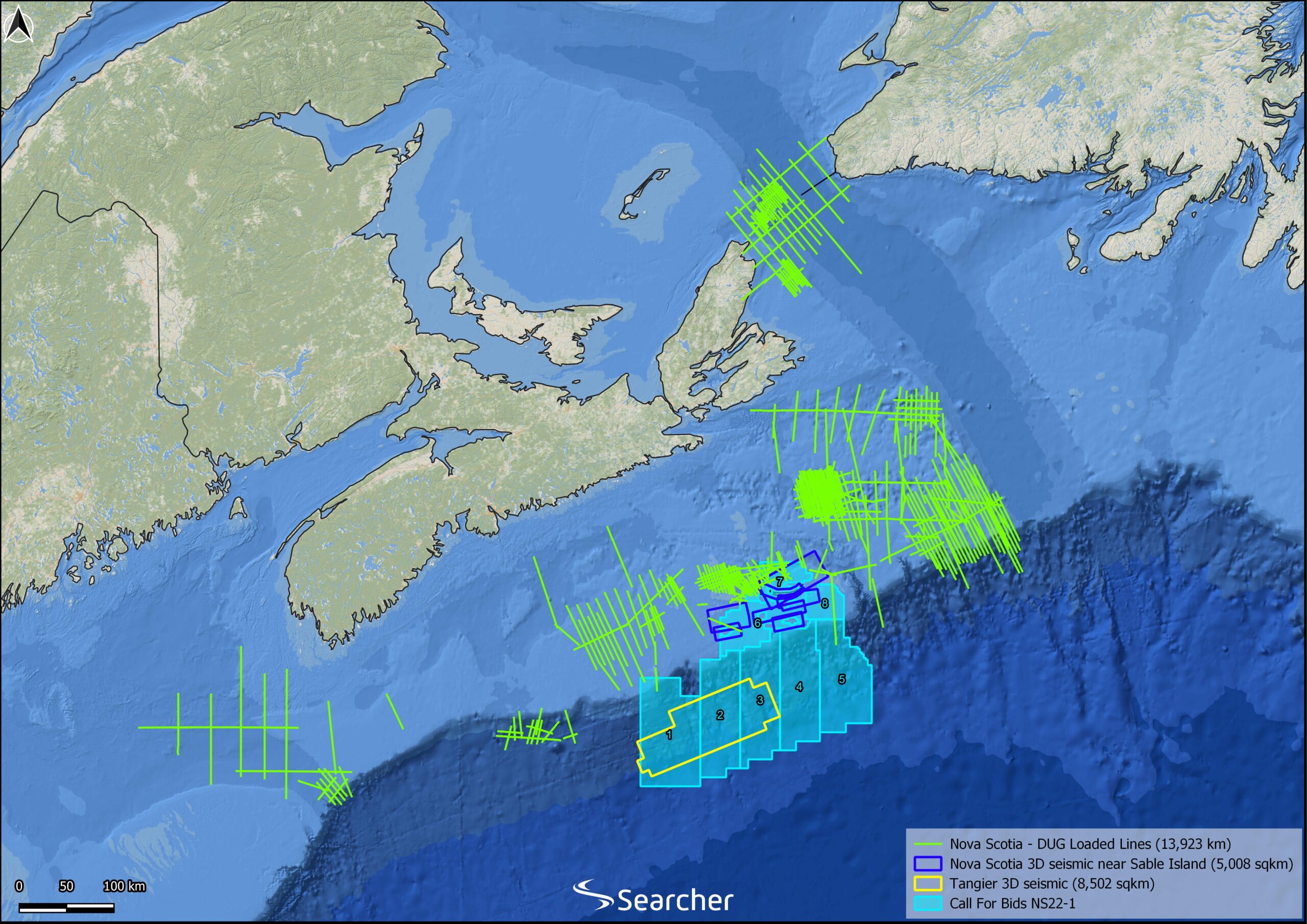
Gas and oil have been discovered and produced on the shelf, yet on the slope, in the salt province, exploration has barely begun. It is here, where a series of open blocks are being offered in the current licence round, that an epic battle between evidence and misconceptions is being fought.
Absence of evidence
It is a commonly held belief that two of the principal players in hydrocarbon exploration off the shelf of Nova Scotia – source and reservoir, are profoundly challenged. It is true that the few exploration wells drilled do leave some elements unproven, but these are knowledge gaps, not negative evidence. Absence of evidence is not evidence of absence, and as Christopher Hitchens has written “what can be asserted without evidence can also be refuted without evidence.” In our industry, the perception of a flaw or an “issue”, let alone two, to a hydrocarbon system in glorious duality is both a huge obstacle and a huge opportunity.
The visionary Aspy well
New scenery on this particular stage: The discovery, in the visionary Aspy-1X sub-canopy well, of a section below the salt where silts and sand cuttings were oil-stained and fluoresced. Were this not evidence of source presence and effectiveness, then let this be conflated with the occurrence of multiple natural slicks and oil in sea bottom cores and the penetration of Middle Jurassic source rock in the along-strike Monterey Jack-1 and Cheshire-1 wells.
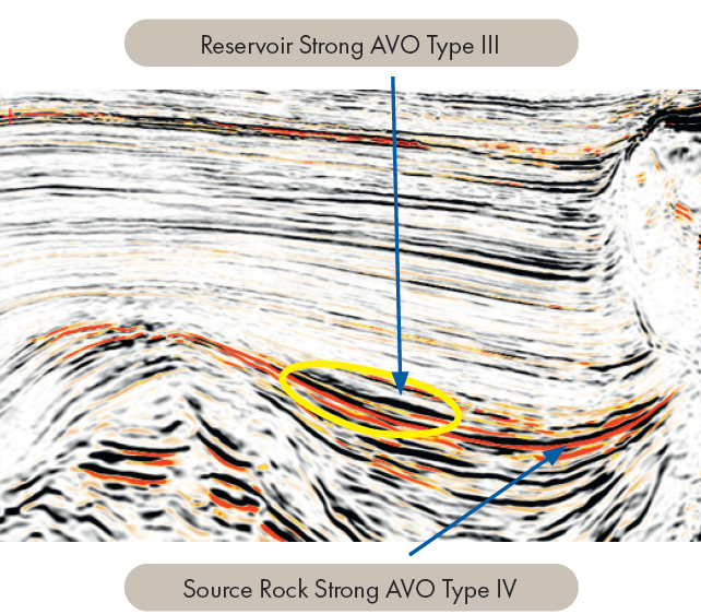
Additionally – one of the world’s most rigorously acquired and processed wide Azimuth (WAZ) 3D datasets lies on this slope – the Tangier 3D. This dataset acquired in 2014 offers a cornucopia of fluid flow and direct hydrocarbon indicators, and Late and Middle Jurassic sections with strong type IV AVO anomalies that scream source rock. The lack of commercial success of Aspy-1X well can be ascribed to a lack of seal in the post-canopy pod/pre-canopy trap configuration, and the scarcity of reservoir rather than a lack of source.
No sands?
The second conceit of the story concerns the lack of reservoirs in the few wells drilled into the Cretaceous on the slope, which showed limited development of Cretaceous sands. This led to the perception that there is no sand in the deep basin – despite its abundance on the sand rich shelf. In order to fully believe that, we would have to imagine that this huge sedimentary section, perhaps 0.5 trillion m3 of sediment, would be comprised only of muds and silts, and salt – no coarse-grained clastics at all. If that were the bet, the Tangier 3D is the weapon of choice to resolve this issue.
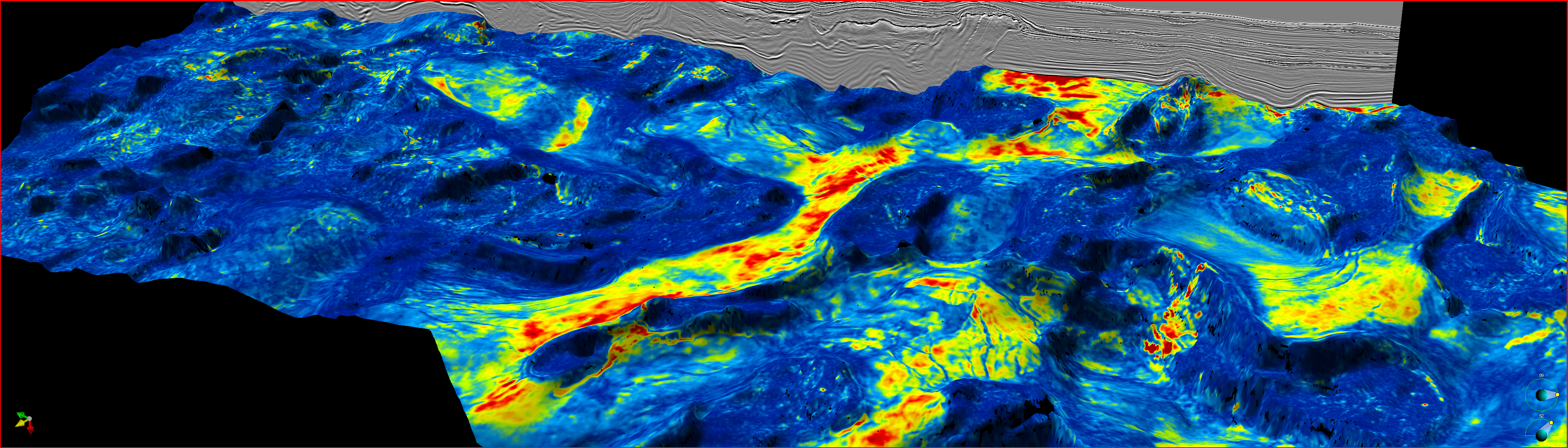
Meandering turbidites
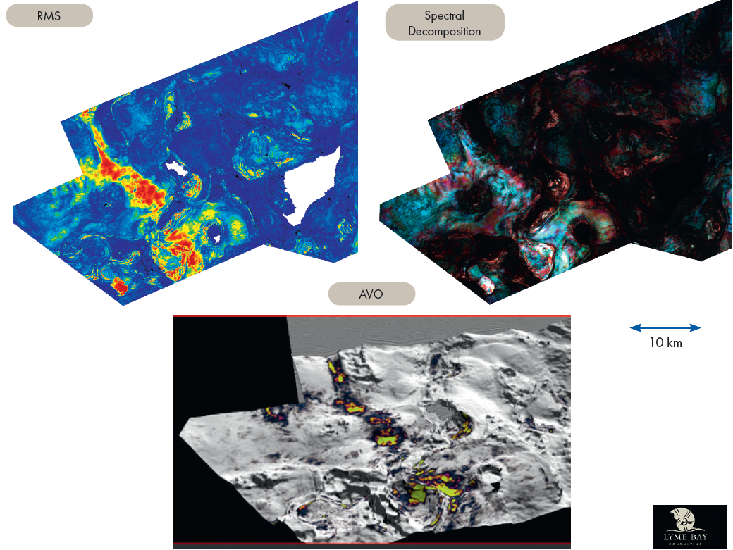
In a collaboration with Lyme Bay Geophysical, we have extracted attributes from the 3D that indicate huge turbidite channel belts flowing down the slope. Without the Tangier 3D though, such fairways would be desperately hard to identify – which, we believe has led to reservoir results in wells drilled to-date. Spectral decomposition along these channels demonstrates the internal character of meandering turbidite flow deposits, bright thalweg channels and lateral accretion packages deposited in channel systems that are limited by levees.
In places, these sand-rich channels have been caught by post-depositional salt movement and now lie in salt wall/salt diapir structural traps, with reservoir stacking similar to the significant recent discoveries in the Campeche Salt Basin offshore Mexico, such as the ENI Yatzil-1 2023 discovery. Elsewhere, channels are seen to run into salt evacuation derived mini-basins where the sands are deposited in fan-like bodies.
Re-writing the narrative
The acquisition and thorough processing of the Tangier WAZ 3D has been the key to re-writing the narrative for the Nova Scotian slope basin. The imbalance in prospectivity analysis that relied on imperfect imaging and limited well data can be re-ordered by imaging of source and reservoir systems on this majestic dataset. The juxtaposition of reservoirs in mini-basin fans and structural channel structural traps in the Upper Jurassic and Cretaceous located on or directly above seismically identified Middle Jurassic source rock suggest uniquely low risk plays, where source and reservoir sat in perfect equipoise.
Searcher have mapped and evaluated a number of such targets, which are associated with positive AVO anomalies (Type 3) and structure conformable amplitude brightening (Figure 2). Taking conservative estimates of net thickness, porosity, Oil saturation, Bo and recovery factors suggest individually that the prospects that we have identified routinely have resource potential for 2 to 4 billion barrels of oil or oil equivalent.
Our detective story on the Nova Scotian slope standing on the shoulders of exploration giants equipped with only 2D data to locate their wells, was set in a stage full of information gaps rather than hydrocarbon negatives. With the help of observations and analysis of one the world’s most technologically advanced and beautiful 3D surveys, we can fill the gaps and reveal enough evidence for the trapping of material oil reserves in deepwater Nova Scotia to create a deeply analytical forensic thriller. Evidence from the Tangier 3D urges us to rise up and apply for acreage in the current Nova Scotian Licence round, “or at least look at the Tangier 3D – you have nothing to lose but your misconceptions.”


