Located in the Norwegian Sea 120 kilometres north of Kristiansund and at a water depth of 320 metres, the Fenja field is on track to be producing first oil by the fourth quarter of 2021. It will be a subsea development tied-back to the Njord-A platform. Operated by Neptune at 30%, licence partners are Vår Energi (45%), Suncor Energy (17.5%) and DNO Norge (7.5%)
Neptune is currently drilling well 6406/12-G-1-H, which will act as a pilot for the location of Fenja’s production and injection wells and will support the appraisal of the Bue discovery. Let’s take a closer look at the geology around the Fenja field to put the development in a geological perspective.
The Fenja field consists of two accumulations that have been drilled by three wells so far. Pil is the most important discovery, in Upper Jurassic Melke Formation sandstones, and was tested by two wells (6406/12-3S and 6406/12-3B). The Bue oil accumulation, in the slightly younger Rogn sandstone, was proven by one well (6406/12-3A).

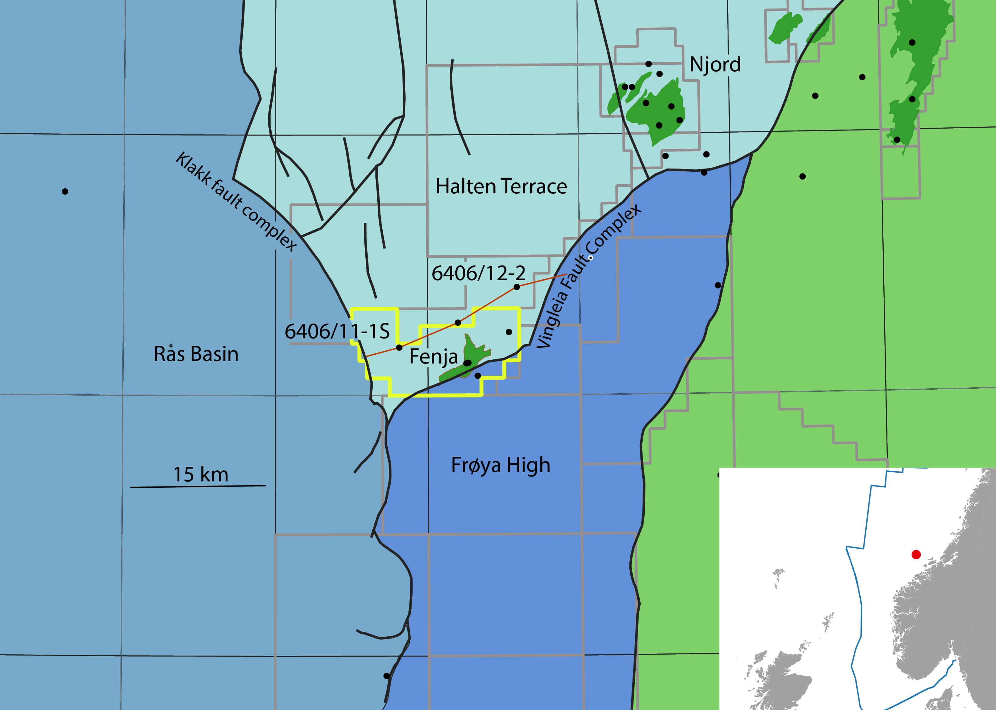
The Fenja field is situated at the southern limit of the Halten Terrace, which is a series of Triassic and Jurassic tilted fault blocks. To the east lies the Frøya High, which is a N-S trending, fault bounded, granite cored basement horst block. The fault separating the Halten Terrace and the Frøya High is the Vingleia fault zone. The western limit of the Halten Terrace is marked by the N-S-striking Klakk Fault Complex.
In Late Jurassic times, the Halten Terrace experienced episodes of active extensional fault movement along the Vingleia fault zone, which resulted in coarse grained sediment supply from the stable Frøya High into the basin. These proximal alluvial fan sandstones have a thickness of hundreds of metres (see wells diagram).
The hydrocarbons trapped in the Pil discovery sit in the topmost part of these proximal sandstones and conglomerates. It can therefore be concluded that the volume of hydrocarbons in the Pil closure depends very much on the depth of the spill point and probably less on the N/G of the pay zone. In contrast, the Bue discovery in the thin Rogn sandstone depends much more on the thickness of the reservoir. It is therefore likely that one of the key factors the current well is appraising is the thickness of the Rogn sandstone in another part of the mapped Bue closure.
Not only the vertical distribution of sand is important in Fenja, the lateral extent of the sands is a key factor too. In that light, Gavin Elliott and co-workers published an interesting article in Basin Research in 2015 in which they describe the depositional and tectonic history of the Halten Terrace in the Fenja area in great detail.

The cross-section above is a modified version of their figure 8. The location of this section is shown on the map above (red line) and runs just north of the Fenja field, which was being drilled at the time the researchers performed their analysis. This section illustrates nicely how restricted the lateral extent of the alluvial sands shed off the Frøya High is. It may well be that within a couple of kilometres north of Fenja the conglomerates of the Melke Formation have transitioned into much finer-grained rocks.
In that light, the description of the Melke Formation in well 12-3A, the most “distal” of the three drilled on Fenja, may already provide a hint towards the northwards shaling out of the formation. It is described as a heterolithic package on the NPD website, which suggests that there are more intercalated fines than in the Melke Formation in the other more southerly positioned wells.
So, despite the apparent abundance of sandstones, the Fenja development is still very much focused on how these sands are distributed in the immediate vicinity of the wells. It’s exciting to see how the development takes shape in the light of the wells currently being drilled.
HENK KOMBRINK
Full reference cited article:
Elliott, G.M., Jackson, C.A-L., Gawthorpe, R.L., Wilson, P., Sharp, I.R. & Michelsen, L., 2015. Late syn-rift tectono-stratigraphic evolution of Vingleia Fault Complex, Halten Terrace, offshore Mid-Norway; a test of rift-basin tectono-stratigraphic models. Basin Research, DOI: 10.1111/bre.12158.