
Exploration Potential in the Southern MSGBC Basin
A new study reveals the plays and opportunities that abound in this exciting region
This article supplies the geological rationale for the review, at present being undertaken by First Exchange Corporation (FEC) in Houston and TGS in the UK, of the exploration potential of The Gambia, southern Senegal (Casamance), the AGC, Guinea-Bissau and Guinea (primarily north of the Guinea Fracture Zone). This work will complement the 2016 review by FEC of Senegal from Casamance northwards to the Mauritanian border, in which a new, oil-prone source of Lower Jurassic age was identified. The factors determining whether oil and gas would be found in deepwater wells were also established.
Following the giant heavy oil (11–13° API) discoveries in the Dome Flore and Dome Gea region of Casamance in the late 1960s/early 1970s, with estimated in-place volumes of 2 Bbo, followed by the 1975 discovery of world-class, oil-prone, mid-Cretaceous source rocks in DSDP boreholes 367 and 368, it was evident that the southern Mauritania-Senegal-Guinea-Bissau- Conakry (MSGBC) Basin should offer multiple opportunities for significant hydrocarbon discoveries. This potential began to be realized following the discovery of the oil and gas fields north-east of Dakar (Tullow and Fortesa) and, more recently, the Sinapa find (Premier Oil) in Guinea-Bissau. However, it was not until 2014 when the Cairn Group drilled their FAN-1 and SNE-1 discovery wells that the magnitude of this potential was confirmed. These successes were followed shortly afterwards by giant finds by Kosmos Energy, though these were of gas rather than the expected oil. The ongoing Guyanese discoveries by ExxonMobil lie on trend across the Atlantic. In 2012 Hyperdynamics discovered a sizeable residual oil accumulation on an Equatorial Atlantic trend in their Sabu-1 well in the far south-east of Guinea.
Geology, plays and opportunities
The pre-rift section includes Devonian and Silurian source rocks, plus reservoir and seal. Triassic rifting initiated the final break-up of Laurentia from Gondwana with salt accumulating below the break-up unconformity in the Casamance failed rift arm. Drift commenced at about 190 Ma (Middle-Lower Jurassic). Growth of a shelf margin carbonate bank, 4–5 km thick, dominated the subsequent Jurassic and early Cretaceous histories. In complete contrast, the younger Cretaceous is characterized by deltaic progradation into the (by then) deepwater settings present west of the carbonate bank. This period is associated with the opening of the Equatorial Atlantic.
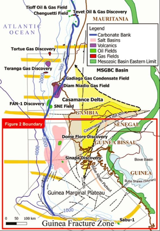
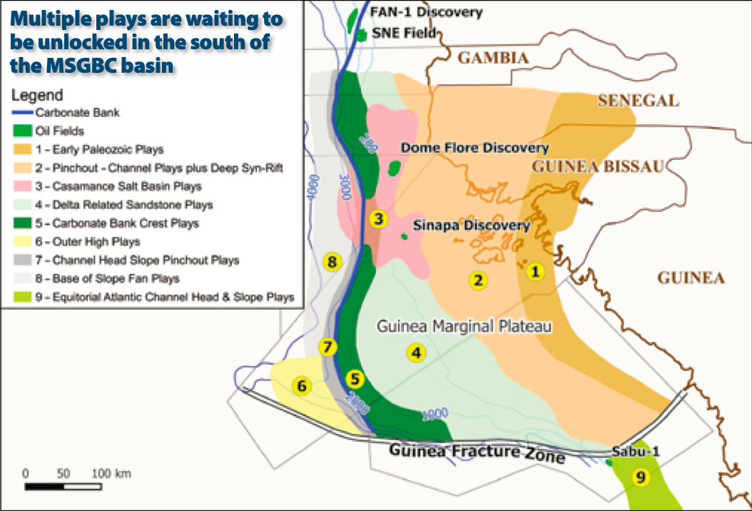
Slower rates of deposition define the Tertiary, and from the Eocene onwards onshore uplift began to influence sedimentation. Diapir growth was renewed in the Dome Flore and Dome Gea region, leading to the development of the cap ‘foraminiferite’ reservoirs. The resulting exploration fabric is summarized in Figure 1. Nine plays are recognized, as illustrated in Figure 2. The SNE discovery occupies play 5 and, where there is salt, play 3. FAN-1 lies in plays 7 and 8, while grainstone bank possibilities are present within play 5. The giant 60 km-long by 20 km-wide closure provided by the Outer High (play 6) offers multiple possibilities.
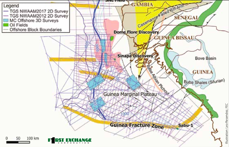
An interpreted line from the TGS NWAAM 2012 2D seismic survey has been used to illustrate a variety of opportunities, some of which are established, and some of which are either emerging or new. This line is presented as the foldout above.
Source rocks
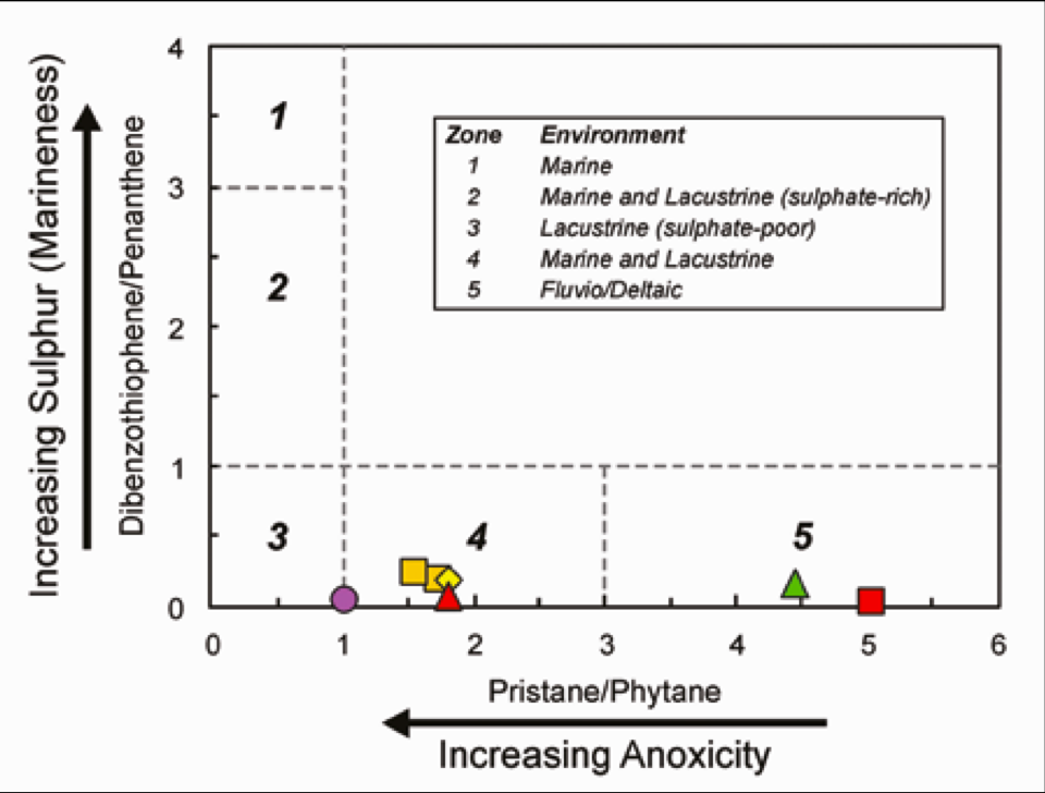
In relation to the established mid-Cretaceous sources of Senegal, oil is located in interlobe settings of the Casamance Delta, and gas sources are associated with depositionally thicker lobe settings. In addition, biomarker evidence for a Lower Jurassic source system was encountered in the onshore wells north-east of Dakar (Figure 3) and indirect evidence was found for the continuation of this source system northwards into Mauritania and southwards into Guinea. A further objective for the new project is to determine whether a Lower Jurassic source exists under the Guinea Marginal Plateau and, if it does, to establish its maturation history in relation to the new and emerging play possibilities. Its existence there would open multiple new opportunities.
Over the past 20 years FEC and its authors, in conjunction with Petroguin, have undertaken substantial geologic studies, including seabed coring and petroleum systems modeling. FEC have recently completed a study in Senegal to help reveal the play concepts further north and are presently working with modern TGS seismic data to publish a new 2017 petroleum systems overview, carrying the knowledge southwards to Guinea-Bissau and Republic of Guinea.
TGS, together with GeoPartners and PGS, are currently acquiring their 12,529 km NWAAM2017 grid (see map above). A fast-track seismic PSTM will be available from June 2017 and will be integrated into the new petroleum systems overview.


