People see the world in different ways. Some people have red/green colour-blindness; some people have acute myopia; nearly all people have some form of astigmatism; some people have synaesthesia; some people cannot see at all; some people choose not to see at all.
I am a geologist by training. A childhood obsession with dinosaurs did not, in fact, lead to a lifetime fascination with ancient life, due to the necessity of dissecting rats during biology classes, which had no appeal whatsoever. At 14 years old, geography and ancient landscapes beckoned instead. Raised in the Weald in southeast England, with the undulating chalk curves of the North and South Downs encompassing the horizons, and the valleys in the middle alternating their sticky clay and crumbling sandstones, geomorphology and thus palaeo-landscapes and geology became my fascination.
To this day, on daily walks in the Wiltshire countryside where I live – another chalk manifestation, smeared with clay by Ice Age scouring – I amuse myself by ‘undressing’ the landscape, and reconstructing the aeons. I see the world in three dimensions. To me, it is natural. I do not believe I can look at the world in any other way; whether surface or subsurface, it is a three-dimensional environment.
I have not, however, spent my career working as a geologist. In the way that life twists and turns, I subsequently moved into reservoir engineering, where I recognised that those who inhabit this discipline, coming from a background in physics or engineering, do not see the world in the same way as myself. 3D is not their viewpoint.
Use the 3D Model
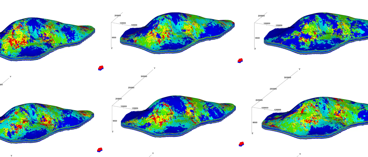
Since the mid 1990s, subsurface software has become increasingly abundantly provided with 3D modelling capabilities. The subsurface workflow is an intricate pattern of surfaces, planes, logs and cross-sections, all dissected and recompiled, with the almost single-minded objective of building a 3D model of the hydrocarbon reservoir – the static model – which is then passed to the reservoir engineer for dynamic modelling, and fluid flow analysis. At which point, although I appreciate why the geological understanding is inclined to evaporate, so, unfortunately, does any desire to look at the dynamic model in 3D, despite the fact that the entire previous workflow has been focused on creating just that.
Yes, endless 2D plots of production profiles, bottomhole pressure, cumulative production etc. are produced, but to actually ‘look’ at the reservoir to understand the behaviour, is most often the last course of action, if it is taken at all. Rather, the cause of a problem in the simulation is sure to be found in those 2D lines, or in Excel spreadsheets…
When still a junior reservoir engineer, I was lucky enough to accompany a senior simulation expert to the Intera offices in Henley, where the first simulation 3D visualisation tool was being developed. We sat there with the developers, and cautiously, watched the eclipse simulation deck loading in this new tool. Slowly, the model appeared in 3D. In the middle of the model was a big hole. There was a silence, and then someone asked: “Is that meant to be there?” To which the reply was, “Actually, no …”.
Since those early days, I have forgotten how many times I have discussed an issue with a colleague, and asked, “Have you looked at the model in 3D?”, to which the inevitable answer is, “No”. So we take a look, and find, for example, that the reason the well is producing only water is that it is perforated in the water leg; that the reason for early water breakthrough is that there is a high permeability streak in the model, due to an incorrect multiplier; that the reason for the convergence problems in the box model was that it was divided into four quarters (for which the reservoir engineer had no real explanation), and one of the quarters had four times the porosity of the other three quarters, which the engineer could not explain. All these things require meticulous checking in the simulation input deck, but are quickly identified in the 3D visualisation.
A Tool for Simulation Engineers
I generalise of course, but with a strong undercurrent of truth. In the reservoir engineering world, 2D comes first, with 3D most often used as a way of demonstrating what is happening to management, rather than as a tool for the simulation engineers themselves. We cannot change the way people think, or how the individual brain maps its surrounding world, but we can ‘choose to see’ when the option is there in front of us, on our desks.